Related Research Articles

Miramichi ( ) is the largest city in northern New Brunswick, Canada. It is situated at the mouth of the Miramichi River where it enters Miramichi Bay. The Miramichi Valley is the second longest valley in New Brunswick, after the Saint John River Valley.
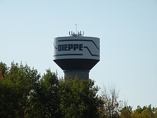
Dieppe is a city in the Canadian maritime province of New Brunswick. Statistics Canada counted the population at 28,114 in 2021, making it the fourth-largest city in the province. On 1 January 2023, Dieppe annexed parts of two neighbouring local service districts; revised census figures have not been released.

Campbellton is a city in Restigouche County, New Brunswick, Canada.

Queens County is located in central New Brunswick, Canada. The county shire town is the village of Gagetown. The county was named as an expression of loyalty to the Crown and to commemorate a group of earlier settlers originally from Queens County, New York.

St. Thomas University is a Catholic, English-language liberal arts university located in Fredericton, New Brunswick, Canada. It is a primarily undergraduate university offering bachelor's degrees in the arts, education, and social work to approximately 1,900 students. The average class size is 30 and no class is larger than 60.

Saint Andrews is a town in Charlotte County, New Brunswick, Canada. The historic town is a national historic site of Canada, bearing many characteristics of a typical 18th century British colonial settlement, including the original grid layout with its market square, and the classical architecture.

Clair is a former Canadian village in Madawaska County, New Brunswick.

Bath is a former village on the Saint John River in Carleton County, New Brunswick, Canada. It held village status prior to 2023 and is now part of the town of Carleton North.
Belledune is a port village in the Canadian province of New Brunswick. It has a population of 1,325, and straddles the boundary between Restigouche County and Gloucester County, New Brunswick.
Metepenagiag, also known as Red Bank is a Mi'kmaq First Nation band government in New Brunswick, Canada on the other side of the Miramichi river from Sunny Corner.
Keswick Ridge is a Canadian rural community in York County, New Brunswick on Route 616.
Rusagonis-Waasis was Canadian local service district in Lincoln Parish, Sunbury County, New Brunswick, which bore the name of two communities within the local service district, Rusagonis and Waasis. Early references use an alternative spelling, Rusagornis, for the community today known as Rusagonis. Some residents advocated changing the governing structure from a local service district into a rural community. It is now mainly part of the incorporated rural community of Sunbury-York South, with the remainder belonging to the city of Fredericton and the Capital region rural district.
Hartin Settlement is a small rural community in western York County, New Brunswick, Canada. Formerly a farming community, it is now home to approximately twenty families. It is located near Lakeland Ridges, New Brunswick.

Higher education in New Brunswick refers to education provided by higher education institutions in the Canadian province of New Brunswick. Higher education has a rich history in New Brunswick. The first English-language university in Canada was the University of New Brunswick. Mount Allison University was the first in the British Empire to award a baccalaureate to a woman, Grace Annie Lockhart, B.Sc. in 1875. Education is the responsibility of the provinces in Canada and there is no federal ministry governing it.

Lincoln is a civil parish in Sunbury County, New Brunswick, Canada.
New Zion is a Canadian unincorporated community in Northfield Parish, Sunbury County, New Brunswick.

Petersville is a civil parish in Queens County, New Brunswick, Canada.

The Grand Bay is a body of water at the confluence of the Wolastoq and Kennebecasis rivers in southern New Brunswick, Canada. The bay is approximately 19.7 km2 and spans across the boundary between Saint John and Kings counties.
References
- ↑ White, James (1916). Dictionary of Altitudes (2nd ed.). Ottawa: Commission of Conservation. p. 84.
Gaspereaux
- 1 2 2016 Census
- ↑ "New Brunswick Regulation 84-168 under the Municipalities Act (O.C. 84-582)". Government of New Brunswick. Retrieved 19 July 2020.
- 1 2 "Wirral". archives.gnb.ca. Place Names of New Brunswick: Where is Home? New Brunswick Communities Past and Present. Retrieved 16 May 2020.
- ↑ "Enniskillen". archives.gnb.ca. Place Names of New Brunswick: Where is Home? New Brunswick Communities Past and Present. Retrieved 16 May 2020.
- ↑ "Blakely". archives.gnb.ca. Place Names of New Brunswick: Where is Home? New Brunswick Communities Past and Present. Retrieved 16 May 2020.
- ↑ Building Stronger Local Governments and Regions John-Guy Finn, November 2008
- ↑ Statistics Canada. 2007. Petersville, New Brunswick (Code1304001) (table). 2006 Community Profiles. 2006 Census. Statistics Canada Catalogue no. 92-591-XWE. Ottawa. Released March 13, 2007.
45°31′14.2″N66°30′10.7″W / 45.520611°N 66.502972°W
| | This New Brunswick location article is a stub. You can help Wikipedia by expanding it. |