
Eucalyptus marginata, commonly known as jarrah, djarraly in Noongar language and historically as Swan River mahogany, is a plant in the myrtle family, Myrtaceae and is endemic to the south-west of Western Australia. It is a tree with rough, fibrous bark, leaves with a distinct midvein, white flowers and relatively large, more or less spherical fruit. Its hard, dense timber is insect resistant although the tree is susceptible to dieback. The timber has been utilised for cabinet-making, flooring and railway sleepers.

Northam is a town in the Australian state of Western Australia, situated at the confluence of the Avon and Mortlock Rivers, about 97 kilometres (60 mi) east-northeast of Perth in the Avon Valley. At the 2016 census, Northam had a population of 6,548. Northam is the largest town in the Avon region. It is also the largest inland town in the state not founded on mining.

Toodyay, known as Newcastle between 1860 and 1910, is a town on the Avon River in the Wheatbelt region of Western Australia, 85 kilometres (53 mi) north-east of Perth. The first European settlement occurred in the area in 1836. After flooding in the 1850s, the townsite was moved to its current location in the 1860s. It is connected by railway and road to Perth. During the 1860s, it was home to bushranger Moondyne Joe.

Forrestfield is a suburb of the City of Kalamunda in Western Australia. It lies 15 kilometres to the south-east of Perth at the base of the Darling Scarp and the southern border of Perth Airport.
Spencers Brook is a waterway, locality and a district located within the Avon Valley in Western Australia.

Great Eastern Highway is a 590-kilometre-long (370 mi) road that links the Western Australian capital of Perth with the city of Kalgoorlie. A key route for road vehicles accessing the eastern Wheatbelt and the Goldfields, it is the western portion of the main road link between Perth and the eastern states of Australia. The highway forms the majority of National Highway 94, although the alignment through the Perth suburbs of Guildford and Midland, and the eastern section between Coolgardie and Kalgoorlie are not included. Various segments form parts of other road routes, including National Route 1, Alternative National Route 94, and State Route 51.
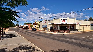
Morawa is a town in the Mid West region of Western Australia. It is located within the Shire of Morawa, approximately 370 kilometres (230 mi) north of the state capital Perth, on the railway line between Wongan Hills and Mullewa.

The Eastern Railway is the main railway route between Fremantle and Northam in Western Australia. It opened in stages between 1881 and 1893. The line continues east to Kalgoorlie as the Eastern Goldfields Railway.
Koolyanobbing is located 54 km (34 mi) north-northeast of the town of Southern Cross, Western Australia. Iron ore has been mined here since 1948 by a series of companies, with a break between 1983 and 1993. The ore is currently railed to the port at Esperance for export. The current owner and operator of the lease is Mineral Resources Limited.

Chidlow is a small community in the Shire of Mundaring approximately 45 kilometres east of Perth, Western Australia.

Bakers Hill is a town 73 kilometres (45 mi) east of Perth, Western Australia on the Great Eastern Highway. The town is located within the Shire of Northam, between Wundowie and Clackline. At the 2021 census, Bakers Hill had a population of 1276.

The Westland was the name given in 1938 to the overnight train operated by the Western Australian Government Railways (WAGR) with sitting and sleeping cars between Perth and Kalgoorlie, where it connected with the Trans-Australian service to Adelaide.

Railways in Western Australia were developed in the 19th century both by the Government of Western Australia and a number of private companies. Today passenger rail services are controlled by the Public Transport Authority through Transperth, which operates public transport in Perth, and Transwa, which operates country passenger services. Journey Beyond operates the Indian Pacific.

Bellevue railway station was a junction station on the Eastern Railway in the Perth suburb of Bellevue.
Charcoal iron is the substance created by the smelting of iron ore with charcoal.
The Kep Track is a bicycle, walking and horse track in the Darling Range and further east in Western Australia.

Highways and main roads in the Wheatbelt region of Western Australia form the basis of a road network, which is primarily used by the mining, agriculture, and tourism industries. Main Roads Western Australia maintains and controls these major roads, with offices based in Northam and Narrogin.

Avon Yard is a railway yard west of Northam, Western Australia. It lies on the southern side of the Avon River on the Eastern Railway between Toodyay and Northam.

Northam railway station is located in Northam on the Eastern Railway route in Western Australia. It is the second and more recent railway station in Northam.

The Wundowie charcoal iron and wood distillation plant manufactured pig iron between 1948 and 1981 and wood distillation products between 1950 and 1977, at Wundowie, Western Australia.

