
Portland Head Light is a historic lighthouse in Cape Elizabeth, Maine. The light station sits on a head of land at the entrance of the primary shipping channel into Portland Harbor, which is within Casco Bay in the Gulf of Maine. Completed in 1791, it is the oldest lighthouse in Maine. The light station is automated, and the tower, beacon, and foghorn are maintained by the United States Coast Guard, while the former lighthouse keepers' house is a maritime museum within Fort Williams Park.
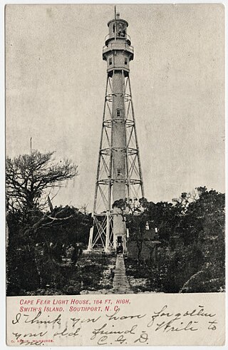
Cape Fear Lighthouse was a coastal beacon built in 1903, replacing the Bald Head Lighthouse as the main navigation aid for Cape Fear and the Frying Pan Shoals off the coast of the U.S. state of North Carolina. It stood near the cape on Bald Head Island. It was a steel octagonal pyramidal skeleton frame lighthouse, as opposed to the conical brick lighthouses usually associated with the state. It was painted red and white horizontal stripes: three white and two red and housed a first-order Fresnel lens produced by the Henry-LePaute Company in France.

Yaquina Head is a headland extending into the Pacific Ocean north of Newport, in the U.S. state of Oregon. It is the site of the Yaquina Head Light, and is managed as Yaquina Head Outstanding Natural Area by the Bureau of Land Management. It is part of the National Landscape Conservation System, commonly known as the National Conservation Lands.
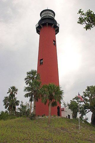
The Jupiter Inlet Light is located in Jupiter, Florida, on the north side of the Jupiter Inlet. The site for the lighthouse was chosen in 1853. It is located between Cape Canaveral Light and Hillsboro Inlet Light. The lighthouse was designed by then Lieutenant George G. Meade of the Bureau of Topographical Engineers. Meade's design was subsequently modified by Lieutenant William Raynolds. The Jupiter Inlet silted shut in 1854, forcing all building supplies to be shipped in light boats down the Indian River. Work was interrupted from 1856 to 1858 by the Third Seminole War. The lighthouse was completed under the supervision of Captain Edward A. Yorke in 1860 at a cost of more than $60,000.

The Dry Tortugas Light is a lighthouse located on Loggerhead Key, three miles west of Fort Jefferson, Florida. It was taken out of operation in 2015. It has also been called the Loggerhead Lighthouse. It has been said to be "a greater distance from the mainland than any other light in the world."

The Plum Island Range Lights are a pair of range lights located on Plum Island in Door County, Wisconsin. They were part of the Plum Island United States Life-Saving Station. Plum Island was transferred to the United States Fish and Wildlife Service in 2007 and became part of the Green Bay National Wildlife Refuge. The life-saving station was listed on the National Register of Historic Places in 2010. Plum Island is seasonally open to the public for day-time use.
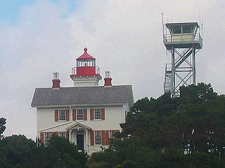
The Yaquina Bay Light is a lighthouse that was built in 1871, soon after the founding of the city of Newport, Oregon, in the United States. It is located on the north side of Yaquina Bay. In 1871–1874, it was the busiest and most populated of the many coastal ports between Washington and California.
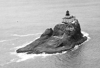
Tillamook Rock Light is a deactivated lighthouse on the northern Oregon Coast of the United States. It is located approximately 1.2 miles (1.9 km) offshore from Tillamook Head, and 20 miles (32 km) south of the mouth of the Columbia River near Astoria, situated on less than an acre of basalt rock in the Pacific Ocean. The construction of the lighthouse was commissioned in 1878 by the United States Congress and took more than 500 days to complete. Shortly before the completion of the lighthouse in January 1881, the barque Lupatia was wrecked near the rock during foggy weather and sank, with the loss of all 16 crew members.

Patos Island Lighthouse is an active aid to navigation overlooking the Strait of Georgia at Alden Point on the western tip of Patos Island in the San Juan Islands, San Juan County, Washington, in the United States. The station is the northernmost in the San Juan Islands and marks the division point between the eastern and western passages into the Strait of Juan de Fuca.
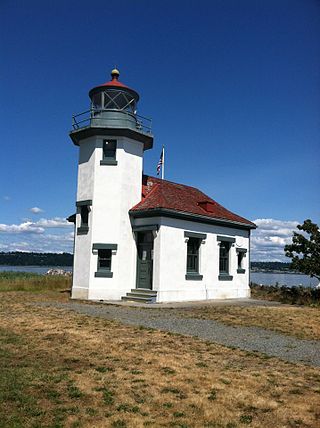
The Point Robinson Light is an operational aid to navigation and historic lighthouse on Puget Sound, located at Point Robinson, the easternmost point of Maury Island, King County, in the U.S. state of Washington. The site was listed on the National Register of Historic Places in 2004.

Point Cabrillo Light is a lighthouse in northern California, United States, between Point Arena and Cape Mendocino, just south of the community of Caspar. It has been a federal aid to navigation since 1909. It is part of the California state park system as Point Cabrillo Light Station State Historic Park.

Punta Gorda Lighthouse is a lighthouse in the United States, 12 miles (19 km) south of Cape Mendocino, California, within Humboldt County. Access is via a short hike from the end of a 4WD road. It is managed by the Bureau of Land Management.
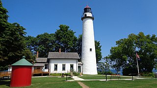
Pointe aux Barques Lighthouse is an active lighthouse located in Huron County in the U.S. state of Michigan. It is located along the shores of Lake Huron on the northeastern tip of the Thumb. Originally constructed in 1848, it is one of the oldest active lighthouses in the state. The name is translated as "point of little boats" from the French language, which refers to the shallow coastline that poses a threat to larger boats.

The Fort Point Light, or Fort Point Light Station, is located in Fort Point State Park, in Stockton Springs, Maine. A lighthouse at this point has served as an active aid to navigation since 1835; the present lighthouse dates to 1857, and is listed on the National Register of Historic Places.

Gay Head Light is a historic lighthouse located on Martha's Vineyard westernmost point off of Lighthouse Road in Aquinnah, Massachusetts.

An Outstanding Natural Area is a protected area designation in the United States. The designations are managed by the Bureau of Land Management within the National Landscape Conservation System. Three ONAs have been designated by Congress, Jupiter Inlet Lighthouse, Piedras Blancas Historic Light Station, and Yaquina Head, all of which protect lighthouses and the adjacent land. The others were named by the BLM and have a variety of resources.

Cleft of the Rock Light is a privately owned lighthouse located on the Pacific coast of the U.S. state of Oregon, 1.8 miles (2.9 km) south of Yachats on Cape Perpetua.

Piedras Blancas Light Station is located at Point Piedras Blancas, about 5.5 miles (8.9 km) west by northwest of San Simeon, California. It was added to the California Coastal National Monument in 2017.

The Noss Head Lighthouse is an active 19th-century lighthouse near Wick in Caithness in the Highland council area of Scotland. It is located at the end of Noss Head, a peninsula on the north-west coast of Caithness that overlooks Sinclairs Bay, three miles north-east of Wick. It is notable as being the first lighthouse that was built with a diagonally-paned lantern room.

The Pass A L'Outre Light is a defunct lighthouse in the Birdfoot Delta in Louisiana, United States, located near the mouth of the Mississippi River. Erected to mark the then-active entrance to the river, it was abandoned as that channel silted up. It has been in the path of several noteworthy hurricanes, and was heavily damaged. It is on the Lighthouse Digest Doomsday List, and is critically in danger. The lighthouse is at the center of a nature preserve.
 Aerial view
 Yaquina Head Lighthouse in 2004. [9]
 Yaquina Head from the north
 First-order Fresnel lens
 Interior view showing the building's iconic marble floor.
 USLHS equipment inside the lighthouse.
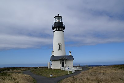 The lighthouse in 2007


