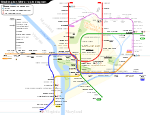
Planning for Metro began with the Mass Transportation Survey in 1955, which attempted to forecast freeway and mass transit systems sufficient to meet the region's needs projected for 1980.[7] In 1959, the study's final report included two rapid transit lines that anticipated downtown Washington subways.[8] Because the plan called for extensive freeway construction within the District of Columbia, alarmed residents lobbied for federal legislation creating a regional transportation agency with a moratorium on freeway construction through July 1, 1962.[9] The new agency, the National Capital Transportation Administration, issued a 1962 Transportation in the National Capital Region report, which did not include the route that became the Yellow Line.[10] A central route under 7th Street in downtown was only added in 1967 primarily to serve the "inner city".[11] In March 1968, the Washington Metropolitan Area Transit Authority (WMATA) board approved its 98-mile (158km) Adopted Regional System (ARS), which included the Yellow Line from Franconia and Backlick Road (in Springfield) to Greenbelt.[12]
While a cut-and-fill tunnel for Yellow Line was built under 7th Street and U Street, street traffic and pedestrian access were difficult.[13] The result was the loss of the traditional retail businesses along the route. The downtown segment of the line was originally projected to open in September 1977.[14] Obtaining approval of the District of Columbia and Prince Georges' County of the exact alignment of the Yellow Line north of U Street delayed construction. Originally, the ARS called for the line to be placed in the median strip of the planned North Central Freeway,.[14] Still, after that road was canceled, the route of the replacement subway tunnel became controversial, resulting in years of expensive delays.[15]
Service on the Yellow Line began on April 30, 1983, adding Archives to the system and linking the two already-built stations of Pentagon and Gallery Place with a bridge across the Potomac River. It was extended beyond National Airport by four stations to Huntington on December 17, 1983, the first station outside the Capital Beltway.[1] When the Green Line link to U Street opened on May 11, 1991, it acted as an extension of the Yellow Line until the southern Green Line branch was completed.[1][13] When Green Line service began, the Yellow Line was truncated at Mount Vernon Square, where a pocket track exists to relay trains.[1]
The Yellow Line was initially planned to follow a slightly different route in Virginia. The plan would have sent Yellow Line trains to Franconia–Springfield, with Blue Line trains serving Huntington. This was changed due to a shortage of rail cars at the time of the completion of the line to Huntington. Because fewer rail cars were required to operate Yellow Line service than would be required to run Blue Line service out to Huntington, the line designations were switched due to the Yellow Line's shorter route. From 1999 to 2008, the Yellow Line operated to Franconia–Springfield on July 4, as part of Metro's special service pattern on that day.[16] In 1998, Congress changed the name of the Washington National Airport to Ronald Reagan Washington National Airport, with the law specifying that no money be spent to implement the name change. As a result, WMATA did not change the name of the National Airport station (which never included the full name of the airport). In response to repeated inquiries from Republican congressmen that the station be renamed, WMATA stated that stations are renamed only at the request of the local jurisdiction. Because Democrats controlled both Arlington County and the District of Columbia, the name change was blocked. Finally, in 2001, Congress made changing the station's name a condition of further federal funding.[17][18][19][20]
In May 2018, Metro announced an extensive renovation of platforms at twenty stations across the system. To accommodate these platform reconstructions, the Blue and Yellow Lines south of Ronald Reagan Washington National Airport would be closed from May 25 to September 8, 2019, in the longest line closure in Metro's history.[21][22] As a result, all Yellow and Blue line services terminated at Ronald Reagan Washington National Airport during the closure.[23]
Between February 13 and May 13, 2021, additional Yellow Line trains began operating between Mount Vernon Square and Franconia–Springfield at all times, replacing the Blue Line due to it being suspended because of platform reconstruction at Arlington Cemetery and Addison Road.[27]
Between May 29 and September 6, 2021, all Yellow Line trains terminated at Mount Vernon Square due to the platform improvement project, which closed stations north of Fort Totten. Shuttle buses were provided to the closed stations while Green Line service replaced service between Mount Vernon Square and Fort Totten.[28]
On June 15, 2022, WMATA announced that all Yellow Line trains will be suspended from September 10, 2022, to May 7, 2023, to tie in the completion of Potomac Yard station and to rehab the 14th Street Bridge the Yellow Line operates over. Service will be replaced by additional Green Line trains, as well as Blue Line trains that will operate between Huntington and New Carrollton stations.[29] On April 4, 2023, WMATA announced they will re-open the Yellow Line on May 7, 2023.[30] The Yellow Line reopened on May 7, 2023, with its northeastern terminus cut back from Greenbelt to Mount Vernon Square.[31]
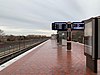
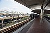
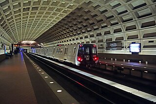
Yellow Line train arriving at the Greenbelt station in Greenbelt, Maryland, the former northern terminus of the line along the Green Line in August 2022
In 2006, Metro board member Jim Graham and Washington, D.C. Mayor Anthony A. Williams proposed re-extending Yellow Line service to Fort Totten or even to Greenbelt. Their proposal did not involve constructing any new track because either extension would run along the same route as the existing Green Line, thus relieving crowding on that line and would require fewer switches to maintain making operations easier. Suburban members of the board initially resisted the proposal. Through a compromise that also increased service on the Red Line, on April 20, 2006, the WMATA board approved a Yellow Line extension to the Fort Totten station during off-peak hours. An 18-month pilot program began on December 31, 2006, at a cost of $5.75 million to the District of Columbia.[35][36] On June 26, 2008, due to the success of the 18-month trial, the Yellow Line was permanently extended to operate up to the Fort Totten Metro Station at all other times other than during weekday rush hour/peak commuter periods.[2]
As part of the Rush Plus initiative trial, additional Yellow Line trains began running between Greenbelt and Franconia-Springfield starting June 18, 2012; these trains were discontinued on June 25, 2017, due to budget cuts.[37] From May 25, 2019, to September 10, 2022, the Yellow Line returned to Greenbelt, this time serving the station at all hours.[38] On May 7, 2023, Yellow Line trains were shortened to Mount Vernon Square at all times being replaced by additional Green Line trains.[30]
The southern terminus of the Yellow Line is adjacent to Kings Highway (Virginia State Route 241) in Fairfax County, Virginia.[39] The line heads northeast on a bridge over Hunting Creek and the Capital Beltway to a station just south of Eisenhower Avenue, which serves several government office buildings, including the United States Patent and Trademark Office. The Yellow Line then merges with the Blue Line and follows the right-of-way of the RF&P Railroad through the City of Alexandria.[39] The line enters a short tunnel under U.S. Route 1. After crossing a bridge over Four Mile Run, the line enters Arlington County on an elevated structure above the National Airport parking lots.[40]
At the north end of the airport, the Yellow Line enters a tunnel under 18th Street South and South Hayes Street in Crystal City.[39] The tunnel continues along the southwest face of the Pentagon which is a 2-level station to facilitate a fork with the Blue Line. After the Pentagon station, the Yellow Line emerges from its tunnel east of the Pentagon and crosses the Charles R. Fenwick Bridge over the George Washington Memorial Parkway, the Potomac River, and Ohio Drive.[39] At the end of the bridge, the Yellow Line re-enters a tunnel near the Jefferson Memorial and crosses under the Washington Channel.[39] The tunnel merges with the Green Line tunnel under 7th Street Southwest just south of the L'Enfant Plaza.[39] The joint Yellow—Green Line tunnel continues north through downtown Washington under 7th Street, turns west under Florida Avenue and U Street, and then north under 14th Street Northwest.[39] The tunnel then turns toward the northeast under Park Road and New Hampshire Avenue.[39] The tunnel then bends eastward under Rock Creek Cemetery and Fort Totten Park to emerge just before entering the lower level of the Fort Totten station. Until May 2019, this was the northern terminal for Yellow Line service, with the track continuing northeast as just the Green Line to the Greenbelt terminus.[39] Between May 2019 and September 2022, the Yellow Line continued along these tracks to Greenbelt.
Internally, the Yellow Line in Virginia was called the "Huntington Route" (C) and the route through the District of Columbia and beyond to Greenbelt as the "Greenbelt Route" (E).[41] As of March 2018, all Yellow Line trains are required only to run 8-car trains.[42][43]
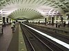
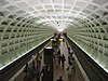
Stations
The following stations are along the line, from south to north.
Built as a multi-level station due to geographic constraints, with trains heading south towards Huntington (Yellow Line) and Franconia-Springfield (Blue Line) on the lower level, and trains heading north towards Mount Vernon Square (Yellow Line) and Downtown Largo (Blue Line) on the upper level.
Northern terminus, Transfer station for the Green Line to Greenbelt
Future
A second improvement project involves building a pedestrian tunnel to interconnect the Gallery Place station with Metro Center. A July 2005 study proposed connecting the eastern mezzanine of Metro Center with the western mezzanine of Gallery Place that are only one block apart. The proposed connection would reduce the number of passengers that use the Red Line to transfer between the Yellow Line and the Blue and Orange lines at Metro Center. As of 2011, the project remained unfunded.[44]
↑ Peak hours are 5 a.m. to 9:30 a.m. and 3 p.m. to 7 p.m.[2]
Related Research Articles
The Washington Metro, often abbreviated as the Metro and formally the Metrorail, is a rapid transit system serving the Washington metropolitan area of the United States. It is administered by the Washington Metropolitan Area Transit Authority (WMATA), which also operates the Metrobus service under the Metro name. Opened in 1976, the network now includes six lines, 98 stations, and 129 miles (208 km) of route.
The Blue Line is a rapid transit line of the Washington Metro system, consisting of 28 stations in Fairfax County, Alexandria and Arlington, Virginia; Washington, D.C.; and Prince George's County, Maryland, United States. The Blue Line runs from Franconia–Springfield to Downtown Largo. The line shares track with the Orange Line for 13 stations, the Silver Line for 18, and the Yellow Line for 7. Only 3 stations are exclusive to the Blue Line.
The Orange Line is a rapid transit line of the Washington Metro system, consisting of 26 stations in Fairfax County and Arlington in Northern Virginia; Washington, D.C.; and Prince George's County, Maryland, United States. The Orange Line runs from Vienna in Virginia to New Carrollton in Maryland. Half of the line's stations are shared with the Blue Line and over two thirds are shared with the Silver Line. Orange Line service began on November 20, 1978.
The Red Line is a rapid transit line of the Washington Metro system, consisting of 27 stations in Montgomery County, Maryland, and Washington, D.C., in the United States. It is a primary line through downtown Washington and the oldest and busiest line in the system. It forms a long, narrow "U," capped by its terminal stations at Shady Grove and Glenmont.
The Green Line is a rapid transit line of the Washington Metro system, consisting of 21 stations in Washington, D.C., and Prince George's County, Maryland, United States. The Green Line runs from Branch Avenue, to Greenbelt, connecting the southeast suburbs to the northeast suburbs through downtown Washington, DC.
Fort Totten station is a Washington Metro station in northeastern Washington, D.C. It is one of the four major transfer points on the Metrorail system. It acts as a transfer point between the Green and Red Lines. It is the last station on the Green Line in the District of Columbia before heading into Maryland and the second to last for the Red Line. It is one of two stations with three levels, and is doubly unique in being the only multi-level transfer station built above ground and being the only such station to have island platforms on both levels, as opposed to just the lower level. The station's name comes from a Civil War-era fortification which itself was named after General Joseph Gilbert Totten, the Chief Engineer of the antebellum US Army.
King Street–Old Town station is a Washington Metro station in Alexandria, Virginia, United States. The station opened on December 17, 1983, and is operated by the Washington Metropolitan Area Transit Authority (WMATA). Providing service for both the Blue and Yellow Lines, this is the southernmost transfer station for the Blue and Yellow lines, as the two lines diverge just south of the station. During inclement weather, Crystal City is commonly used as an unofficial transfer point, being the southernmost underground station common to both lines. King Street was originally served only by the Yellow Line, until the Blue Line was extended from National Airport to Van Dorn Street in 1991.
Eisenhower Avenue station is a rapid transit station on the Yellow Line of the Washington Metro in Alexandria, Virginia. It opened on December 17, 1983.
Huntington station is an island-platformed Washington Metro station in the Huntington area of Fairfax County, Virginia, United States. The station was opened on December 17, 1983, and is operated by the Washington Metropolitan Area Transit Authority (WMATA). Serving as the southern terminus for the Yellow Line, the station is built into a hillside; the south mezzanine, along with escalator access, is accessible via an incline elevator.
Braddock Road station is an island-platformed Washington Metro station in Alexandria, Virginia, United States. The station was opened on December 17, 1983, and is operated by the Washington Metropolitan Area Transit Authority (WMATA). Providing service for both the Blue and Yellow Lines, the station is located at Braddock Road and West Street.
Mount Vernon Square station is a Washington Metro station in Washington, D.C., on the Green and Yellow Lines. It is the northeastern terminus of the Yellow Line.
Shaw–Howard University station is a Washington Metro station in Washington, D.C., on the Green Line. The station primarily serves Washington's Shaw neighborhood, the home of Howard University.
U Street station is a rapid transit station on the Green Line of the Washington Metro in the U Street neighborhood of Washington, D.C.
Columbia Heights station is a Washington Metro station in Washington, D.C., on the Green Line. Due to successful redevelopment since the station's opening, Columbia Heights is one of the busiest Metro stops outside the downtown core, with over four million exits in 2010.
Georgia Avenue–Petworth station is a Washington Metro station in Washington, D.C., on the Green Line. It is located at the border of the neighborhoods of Petworth, Sixteenth Street Heights, and Park View in Northwest.
West Hyattsville station is a Washington Metro station in Hyattsville, Maryland on the Green Line. It is the first station in Prince George's County, Maryland northeast on the Green Line, and is located at 2700 Hamilton Street, near the west side of Ager Road and the north side of Queens Chapel Road.
Hyattsville Crossing station is a Washington Metro station in Hyattsville, Maryland, on the Green Line. It opened on December 11, 1993, as Prince George's Plaza, referencing the nearby Prince George's Plaza, now known as The Mall at Prince Georges. The station has a unique layout in that it is an open-cut side platformed station with a parking garage directly over the tracks.
College Park–University of Maryland station is a Washington Metro station in Prince George's County, Maryland, on the Green Line. It also serves MARC's Camden Line, though only select trains stop at the station.
Greenbelt station is a Washington Metro and MARC station in Prince George's County, Maryland. The station is the northeastern terminus of the Green Line of the Washington Metro. MARC commuter rail trains on the Camden Line also stop at Greenbelt on a set of tracks parallel to the Metro tracks.
Van Dorn Street station is a Washington Metro station straddling the boundary between Fairfax County and the independent city of Alexandria in Virginia, United States. The station’s island platform lies in unincorporated Rose Hill in Fairfax County, while the station’s entrance and parking facilities are in Alexandria. The station was opened on June 15, 1991, and is operated by the Washington Metropolitan Area Transit Authority (WMATA). Providing service for only the Blue Line, the station is located at South Van Dorn Street and Eisenhower Avenue, next to the Capital Beltway. From 1991 to 1997 it was the southwestern terminus of the Blue Line.
This page is based on this Wikipedia article Text is available under the CC BY-SA 4.0 license; additional terms may apply. Images, videos and audio are available under their respective licenses.