
A truss bridge is a bridge whose load-bearing superstructure is composed of a truss, a structure of connected elements, usually forming triangular units. The connected elements may be stressed from tension, compression, or sometimes both in response to dynamic loads. The basic types of truss bridges shown in this article have simple designs which could be easily analyzed by 19th and early 20th-century engineers. A truss bridge is economical to construct because it uses materials efficiently.
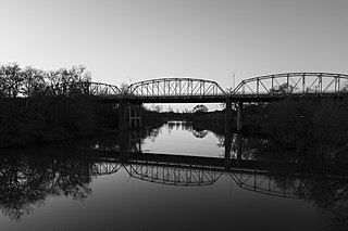
The Colorado River Bridge at Bastrop is a 1,285-foot (392 m)-long bridge with three steel truss spans and concrete piers that crosses the Colorado River as part of Loop 150 through Bastrop, Texas. The three bridge spans over the river consist of identical Parker through trusses, each 192 feet (59 m) in length, supported on concrete piers. The bridge is one of the earliest surviving uses of the Parker truss in Texas.

Chevelon Creek Bridge is a historic road bridge located about 12 miles (19 km) southeast of Winslow, in Navajo County, eastern Arizona, United States. It is a steel Warren Pony truss bridge over Chevelon Creek, built on the first permanent road connecting Holbrook, the seat of Navajo County, and Winslow. When built, the road was regionally important in northern Arizona as well as being a segment of an early national highway at the time automobile traffic was growing and national roads were first being formed. The bridge was listed on the National Register of Historic Places in 1983 for being a rare design in Arizona, part of an early transnational roadway, one of the first bridges built by Arizona after statehood in 1912, and being in nearly original condition.

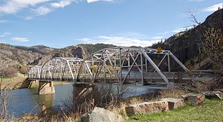
The Kettle Falls Bridges is the collective name for a pair of steel cantilever bridges carrying State Route 20/U.S. Route 395 and the Kettle Falls International Railway across the Columbia River at Kettle Falls, Washington. The south bridge carries motor vehicle traffic while the similar northern span is used for rail.

The Yale Bridge or Lewis River Bridge spans the Lewis River near Yale, Washington. It was built in 1932 by Cowlitz and Clark counties. The suspension bridge has a clear span of 300 feet (91 m), with a total length of 532 feet (162 m), replacing a previous steel truss bridge at the site. Construction of the Ariel Dam had created Lake Merwin with a water depth of 90 feet (27 m) at the site, requiring a new bridge that did not need to have support piers in the water. The road deck, stiffened by a steel Warren truss, is 50 feet (15 m) above the high water line of the reservoir.

The Lake Shore Drive Bridge, also known as the M-26 Bridge or the Eagle River Bridge, is a pedestrian bridge in Eagle River, Michigan, crossing the Eagle River. It carried highway M-26 over the river from 1915 until 1990, when the adjacent Eagle River Timber Bridge replaced it for automobile traffic. The Lake Shore Drive Bridge is listed as a Michigan State Historic Site and is a contributing property of the Eagle River Historic District.

The Powder River Bridge is a bridge spanning the Powder River just above its confluence with the Yellowstone River in Prairie County, Montana. It was added to the National Register of Historic Places on January 4, 2010. It is a steel truss style bridge built in 1946. The bridge is 633 feet in length consisting of a 203-foot main truss span and two 163-foot truss spans.
The Jefferson Street Viaduct is an historic structure located in Ottumwa, Iowa, United States. The riveted Warren deck truss bridge was completed in 1936. It was listed on the National Register of Historic Places in 1998 as a part of the Highway Bridges of Iowa MPS.
The Parker Road–Charlotte River Bridge, also known as the 10 Mile Road–Charlotte River Bridge, is a bridge building located on Parker Road over the Charlotte River in Bruce Township, Michigan. It was listed on the National Register of Historic Places in 2000.

The AJX Bridge is a historic Pratt truss bridge in southwestern Johnson County, Wyoming. The bridge was built in 1931 across the South Fork of the Powder River near Kaycee, Wyoming. AJX Bridge was built to provide a river crossing for U.S. Route 87. It was placed on the National Register of Historic Places in 1985 as part of a Multiple Property Submission devoted to historic bridges in Wyoming.

The Butts Bridge carries Butts Bridge Road over the Quinebaug River in the town of Canterbury, Connecticut. It is a well-preserved example of a Parker truss, built in 1937, late in the state's regular use of steel truss bridge designs. The bridge is also known as Bridge No. 1649 and carries an average of 2,300 vehicles per day as of 2011. It was listed on the National Register of Historic Places in 2010.
Hardy Bridge is a Warren through truss, three-span, two-lane bridge in the western United States. It crosses the Missouri River and is located at milepost 6 on Old U.S. Route 91, about fourteen miles (23 km) southwest of Cascade, Montana, which is southwest of Great Falls.
The Hurricane-La Verkin Bridge spans the Virgin River, connecting the towns of Hurricane and LaVerkin in southern Utah, United States.

The Williams River Route 5 Bridge is a historic Warren deck truss bridge, carrying U.S. Route 5 (US 5) across the Williams River in Rockingham, Vermont. Built in 1929 and rebuilt in 1971-72, it is one of four bridges of this type and vintage in the state. It was listed on the National Register of Historic Places in 1991.

The Gould's Mill Bridge is a historic Baltimore through truss bridge, carrying Paddock Street across the Black River in Springfield, Vermont. The bridge was built by the Boston Bridge Works Company in 1929 after major flooding in 1927, and is one of the state's few examples of a Baltimore truss. It was listed on the National Register of Historic Places in 2006.

The Lover's Lane Bridge is a historic bridge spanning the Dog River in Berlin, Vermont. Built in 1915, it is a rare early 20th-century example of a Warren pony truss bridge. It was listed on the National Register of Historic Places in 2006 as Bridge No. 27.
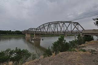
Completed in 1926 at a cost of $305,000, the Bell Street Bridge crosses the Yellowstone River in Glendive, Montana. Designed by the Montana Highway Commission and built by contractor Boomer, McGuire & Blakesley, the 1,352 feet (412 m) long, 20 feet (6.1 m) wide bridge consists of six Warren through truss spans, each roughly 219 feet (67 m) long, and a concrete approach span about 38 feet (12 m) long. It was listed on the National Register of Historic Places in 1988. At one time the main highway bridge over the river, Montana DOT rehabilitated and converted it for pedestrian use in 1992 when the bridge on the I-94 Business Loop was built 300’ to the north.

The Scenic Bridge crossing Clark Fork River about 4 miles (6.4 km) east of Tarkio in Mineral County, Montana, was built in 1928. It is located at Milepost 0 on Old U.S. Route 10 West. The bridge has also been denoted 24MN304 and MDT No. L31012000+08. It was listed on the National Register of Historic Places in 2010.

The Hutchins Bridge, spanning the Madison River in Madison County, Montana near Cameron, Montana, was listed on the National Register of Historic Places in 1999.
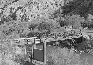
The Black River Bridge near Carrizo, Arizona was funded in 1911 and built in 1912. It was listed on the National Register of Historic Places in 1988. It spans the Black River, bringing an army road, now Indian Route 9, over the river from Fort Apache to the railroad at the former town of Rice, Arizona.


