Victoria is the capital city of the Canadian province of British Columbia, on the southern tip of Vancouver Island off Canada's Pacific coast. The city has a population of 91,867, and the Greater Victoria area has a population of 397,237. The city of Victoria is the 7th most densely populated city in Canada with 4,405.8 inhabitants per square kilometre (11,411/sq mi).

Vancouver Island is an island in the northeastern Pacific Ocean and part of the Canadian province of British Columbia. The island is 456 km (283 mi) in length, 100 km (62 mi) in width at its widest point, and 32,100 km2 (12,400 sq mi) in total area, while 31,285 km2 (12,079 sq mi) are of land. The island is the largest by area and the most populous along the west coasts of the Americas.

Point Roberts is a pene-exclave of Washington on the southernmost tip of the Tsawwassen peninsula, south of Vancouver, Canada. The area, which had a population of 1,191 at the 2020 census, is reached by land from the rest of the United States by traveling 25 mi (40 km) through Canada. It is a census-designated place in Whatcom County, Washington, with a post office, and a ZIP Code of 98281. Direct sea and air connections with the rest of the U.S. are available across Boundary Bay.

Saysutshun Provincial Park, formally known as Newcastle Island Marine Provincial Park, is a provincial park located on a small island off the coast of Nanaimo, British Columbia, Canada.

The Kʼómoks or Kʼomoks, usually known in English as the Comox, are an indigenous group of Coast Salishan-speaking people in Comox, British Columbia and in Toba Inlet and the Malaspina Peninsula areas of the British Columbia mainland across Georgia Strait. They historically spoke the Komox language (Comox-Sliammon), and were divided in two main dialect and tribal groupings, which are known by academics as Island Comox and Mainland Comox.

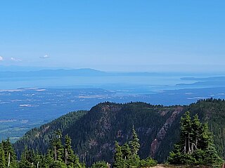
The Strait of Georgia or the Georgia Strait is an arm of the Salish Sea between Vancouver Island and the extreme southwestern mainland coast of British Columbia, Canada and the extreme northwestern mainland coast of Washington, United States. It is approximately 240 kilometres (150 mi) long and varies in width from 20 to 58 kilometres. Along with the Strait of Juan de Fuca and Puget Sound, it is a constituent part of the Salish Sea.

The history of British Columbia covers the period from the arrival of Paleo-Indians thousands of years ago to the present day. Prior to European colonization, the lands encompassing present-day British Columbia were inhabited for millennia by a number of First Nations.

The Island Rail Corridor, previously the Esquimalt & Nanaimo Railway, is a railway operation on Vancouver Island and is the only remaining railway on Vancouver Island after the closure of the Englewood Railway in November 2017. The Island Corridor Foundation owns the former Esquimalt & Nanaimo Railway corridor. The railway line is 225 kilometres (140 mi) in length from Victoria to Courtenay, known as the Victoria Subdivision, with a branch line from Parksville to Port Alberni known as the Port Alberni Subdivision at 64 kilometres (40 mi) in length, for a total 289 kilometres (180 mi) of mainline track. In 2006, the Island Corridor Foundation acquired the railway's ownership from the Canadian Pacific Railway.

Courtenay is a city on the east coast of Vancouver Island, in the Canadian province of British Columbia. It is the largest community and only city in the area commonly known as the Comox Valley, and the seat of the Comox Valley Regional District, which replaced the Comox-Strathcona Regional District. Courtenay is 4 km (2.5 mi) west of the town of Comox, 7 km (4.3 mi) northeast of the village of Cumberland, 5 km (3.1 mi) northwest of the unincorporated settlement of Royston, and 108 km (67 mi) northwest of Nanaimo. Along with Nanaimo and Victoria, it is home to The Canadian Scottish Regiment, a Primary Reserve infantry regiment of the Canadian Armed Forces.

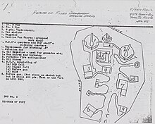
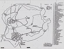
Fort Stevens was an American military installation that guarded the mouth of the Columbia River in the state of Oregon. Built near the end of the American Civil War, it was named for a slain Civil War general and former Washington Territory governor, Isaac I. Stevens. The fort was an active military reservation from 1863–1947. It is now listed on the National Register of Historic Places.

The Regional District of Comox-Strathcona was a regional district of British Columbia, Canada from 1967 to 2008. On February 15, 2008, the regional district was abolished and replaced by two successor regional districts, Comox Valley and Strathcona.
The Comox Valley is a region on the east coast of Vancouver Island, British Columbia, Canada, that includes the city of Courtenay, the town of Comox, the village of Cumberland, and the unincorporated settlements of Royston, Union Bay, Fanny Bay, Black Creek, and Merville. The communities of Denman Island and Hornby Island are also considered part of the Comox Valley. The Comox Valley contains the 47th largest metropolitan area in Canada with a population of about 76,000 as of 2022
Cumberland is an incorporated village municipality east of Perseverance Creek, near the east coast of central Vancouver Island, British Columbia. The Comox Valley community is west of BC Highway 19 and is by road about 105 kilometres (65 mi) northwest of Nanaimo and 10 kilometres (6 mi) southwest of Courtenay.
Seaspan ULC provides marine-related services to the Pacific Northwest. Within the Group are three shipyards, an intermodal ferry and car float business, and also a tug and barge transportation company that serves both domestic and international markets. Seaspan, is part of the Washington Companies that are owned by Dennis Washington. Kyle Washington, is the Executive Chairman of Seaspan, who has become a Canadian citizen.

The Discovery Islands are a group of islands located at the northern end of the Salish Sea and the eastern end of Johnstone Strait, between Vancouver Island and the mainland coast of British Columbia, Canada.

The British Columbia Coast, popularly referred to as the BC Coast or simply the Coast, is a geographic region of the Canadian province of British Columbia. As the entire western continental coastline of Canada along the Pacific Ocean is in B.C., it is synonymous with being the West Coast of Canada.

Johnstone Strait is a 110 km (68 mi) channel along the north east coast of Vancouver Island in British Columbia, Canada. Opposite the Vancouver Island coast, running north to south, are Hanson Island, West Cracroft Island, the mainland British Columbia Coast, Hardwicke Island, West Thurlow Island and East Thurlow Island. At that point, the strait meets Discovery Passage which connects to Georgia Strait.

Victoria Harbour is a harbour, seaport, and seaplane airport in the Canadian city of Victoria, British Columbia. It serves as a cruise ship and ferry destination for tourists and visitors to the city and Vancouver Island. It is both a port of entry and an airport of entry for general aviation. Historically it was a shipbuilding and commercial fishing centre. While the Inner Harbour is fully within the City of Victoria, separating the city's downtown on its east side from the Victoria West neighbourhood, the Upper Harbour serves as the boundary between the City of Victoria and the district municipality of Esquimalt. The inner reaches are also bordered by the district of Saanich and the town of View Royal. Victoria is a federal "public harbour" as defined by Transport Canada. Several port facilities in the harbour are overseen and developed by the Greater Victoria Harbour Authority, however the harbour master's position is with Transport Canada.

Hardwicke Island is an island in British Columbia, Canada, measuring approximately 78 square kilometres (30 sq mi).
Debra Sparrow, or θəliχʷəlʷət (Thelliawhatlwit), is a Musqueam weaver, artist and knowledge keeper. She is self-taught in Salish design, weaving, and jewellery making.