Yuma Crossing

Last updated
Yuma Crossing and Associated Sites
Yuma Crossing and RR bridge in 1886.jpg
USA California location map.svg
Red pog.svg
Usa edcp location map.svg
Red pog.svg
Nearest city Winterhaven, California and Yuma, Arizona
Coordinates 32°43′43″N114°36′56″W / 32.72861°N 114.61556°W / 32.72861; -114.61556 Coordinates: 32°43′43″N114°36′56″W / 32.72861°N 114.61556°W / 32.72861; -114.61556
Area149 acres (60 ha)
Built1852
NRHP reference No. 66000197 [1]
Significant dates
Added to NRHPNovember 13, 1966 [1]
Designated NHLDNovember 13, 1966 [2]

Yuma Crossing is a site in Arizona and California that is significant for its association with transportation and communication across the Colorado River. It connected New Spain and Las Californias in the Spanish Colonial period in [2] and also during the Western expansion of the United States. Features of the Arizona side include the Yuma Quartermaster Depot and Yuma Territorial Prison. Features on the California Side include Fort Yuma, which protected the area from 1850 to 1885. [3] [4]

Contents

History

Yuma Crossing Marker Yuma-Yuma Crossing.jpg
Yuma Crossing Marker

The history of the Yuma Crossing began at the formation of two massive granite outcroppings on the Colorado River. The narrowing of the river provided the only crossing point for a thousand miles, thus making it a focal point for the Patayan tribes, and later the Quechan.

In 1540, well before the British Europeans touched Plymouth Rock in 1620, Yuma's European history began here with the arrival of Spanish explorer Hernando de Alarcón. It was not until after the 17th and 18th century explorations of the padres Kino and Garcés that the crossing came to be used by the Spanish expeditions of Juan Bautista de Anza and others along this route from 1774. This route, sometimes called the Sonora Road, ran from the Spanish Tubac Presidio, in Sonora to Alta California. An attempt to establish missions and colonize the area of the crossing was made by the Spanish soon after but it failed, when the formerly friendly Quechan were angered to the point of a violent revolt that ended the missions, the colony and the use of the land route until the 19th century. Mexican expeditions mollified the Quechan and persuaded them to allow the use of the crossings, reopening the Sonora Road to Alta California from the later 1820s.

Much later the Yuma Crossing became the focal point for travel to the Wild West, from the 1840s California Gold Rush era to the arrival of the railroad in the 1877, and finally the Ocean-to-Ocean Bridge, which linked the East coast and the West coast in one land route.

Immediately after the Mexican–American War in 1848, the U.S. Army built Fort Yuma here to protect travelers from Indians raiding the area. It was the center point of conflict in the Yuma War of 1850–53. From 1864–1890, the fort and nearby facilities was the main army base to support the US Army's efforts to control the Indians throughout the greater southwest.

At about the same time, the Butterfield Stage established a stagecoach station here for their main line coming from the east to California.

It was declared a National Historic Landmark in 1966, under the name Yuma Crossing and Associated Sites. [2] [5]

National Heritage Area

The Yuma Crossing National Heritage Area is a U.S. National Heritage Area. It was the only lower Colorado River crossing point in the 18th and 19th centuries for non-Native American travelers and immigrants. The Heritage Area is part of the Yuma Crossing and Associated Sites on the National Register of Historic Places and a National Historic Landmark, in Arizona and California.

As with other U.S. National Heritage Areas, the Yuma Crossing National Heritage Area is a local entity in partnership with various stakeholders. At Yuma Crossing, the stakeholders are particularly diverse, including Indian tribes, agricultural interests, environmental and wildlife non-profit organizations, as well as many federal, states, and local agencies.

History park

The Yuma Crossing National Heritage Area includes the Yuma Quartermaster Depot State Historic Park (formerly known as Yuma Crossing State Historic Park), the Yuma Territorial Prison, Fort Yuma, and other sites, all showcasing the area's history. They are amidst the beautiful and vital Yuma East and West Wetlands, and against the silhouetted backdrops of the Castle Dome, Chocolate (Arizona) and Chocolate (California) Mountains.

The heritage area's interpretive themes include Yuma's importance as a cultural crossroads, emphasizing the region's intersection of three major cultures: Anglo-American, Native American, and Hispanic-Latino. The heritage area recognizes that this rich blend of traditions can best be sustained by their continued expression through architecture, art, music, food, and folkways within the heritage area.

Juan Bautista de Anza National Historic Trail

The Yuma Crossing is a designated site of the Juan Bautista de Anza National Historic Trail, a National Park Service area in the United States National Trails System.

Habitat restoration

The Yuma Heritage Area has championed a wetland and riparian habitat restoration project for the East Wetlands, including returning the Colorado's water flow, in a multiyear, multimillion-dollar effort. In 2004, heritage area partners secured a Clean Water Act permit from the U.S. Army Corps of Engineers to begin restoration work. More than 200 acres (0.81 km2) of nonnative invasive species vegetation have been removed and more than 130 acres (0.53 km2) have been replanted with cottonwoods, willow, mesquite, native bunchgrasses, and palo verde trees. A one-mile (1.6 km) length of back channel has also been excavated, and some 20,000 new trees were planted in 2006.

To date, ten different funding sources have provided almost $6 million toward the eventual goal of $18–20 million to complete the project. [6] [7] [8]

Area plant life

See also

Related Research Articles

<span class="mw-page-title-main">Juan Bautista de Anza</span> 18th-century Basque explorer and governor within the Spanish Empire

Juan Bautista de Anza Bezerra Nieto was an expeditionary leader, military officer, and politician primarily in California and New Mexico under the Spanish Empire. He is credited as one of the founding fathers of Spanish California and served as an official within New Spain as Governor of the Province of New Mexico.

<span class="mw-page-title-main">Cocopah</span> Native Americans living in Baja California and Sonora, Mexico, and Arizona in the USA

The Cocopah are Native Americans who live in Baja California, Mexico, and Arizona, United States.

<span class="mw-page-title-main">Quechan</span> Ethnic group and federally-recognized tribe in Arizona, United States

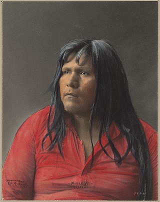
The Quechan are a Native American tribe who live on the Fort Yuma Indian Reservation on the lower Colorado River in Arizona and California just north of the Mexican border. Despite their name, they are not related to the Quechua people of the Andes. Members are enrolled into the Quechan Tribe of the Fort Yuma Indian Reservation. The federally recognized Quechan tribe's main office is located in Winterhaven, California. Its operations and the majority of its reservation land are located in California, United States.

<span class="mw-page-title-main">Yuma, Arizona</span> City in Arizona, United States

Yuma is a city in and the county seat of Yuma County, Arizona, United States. The city's population was 93,064 at the 2010 census, up from the 2000 census population of 77,515.

<span class="mw-page-title-main">Sonoran Desert</span> Desert in northwestern Mexico and the southwestern United States

The Sonoran Desert is a desert in North America and ecoregion that covers the northwestern Mexican states of Sonora, Baja California, and Baja California Sur, as well as part of the southwestern United States. It is the hottest desert in both Mexico and the United States. It has an area of 260,000 square kilometers (100,000 sq mi).

<span class="mw-page-title-main">Francisco Garcés</span> Explorer, missionary (1738–1781)

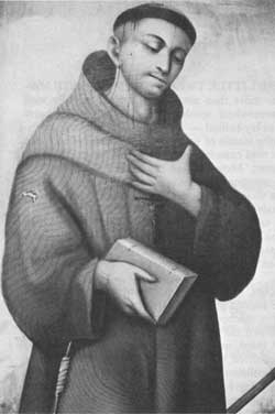
Francisco Hermenegildo Tomás GarcésO.F.M. was a Spanish Franciscan friar who served as a missionary and explorer in the colonial Viceroyalty of New Spain. He explored much of the southwestern region of North America, including present day Sonora and Baja California in Mexico, and the U.S. states of Arizona and California. He was killed along with his companion friars during an uprising by the Native American population, and they have been declared martyrs for the faith by the Catholic Church. The cause for his canonization was opened by the Church.

<span class="mw-page-title-main">Juan Bautista de Anza National Historic Trail</span> United States National Park Service unit

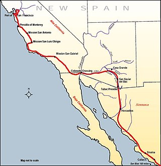
The Juan Bautista de Anza National Historic Trail is a 1,210-mile (1,950 km) trail extending from Nogales on the U.S.-Mexico border in Arizona, through the California desert and coastal areas in Southern California and the Central Coast region to San Francisco. The trail commemorates the 1775–1776 land route that Spanish commander Juan Bautista de Anza took from the Sonora y Sinaloa Province of New Spain in Colonial Mexico through to Las Californias Province. The goal of the trip was to establish a mission and presidio on the San Francisco Bay. The trail was an attempt to ease the course of Spanish colonization of California by establishing a major land route north for many to follow. It was used for about five years before being closed by the Quechan (Yuma) Indians in 1781 and kept closed for the next 40 years. It is a National Historic Trail administered by the National Park Service and was also designated a National Millennium Trail.

<span class="mw-page-title-main">Spanish missions in Arizona</span> 17th to 19th-century Catholic religious outposts

Beginning in the 16th century Spain established missions throughout New Spain in order to facilitate colonization of these lands.

<span class="mw-page-title-main">Fort Yuma</span> US Army fort (1851–1853) in California near Yuma, Arizona

Fort Yuma was a fort in California located in Imperial County, across the Colorado River from Yuma, Arizona. It was on the Butterfield Overland Mail route from 1858 until 1861 and was abandoned May 16, 1883, and transferred to the Department of the Interior. The Fort Yuma Indian School and the Saint Thomas Yuma Indian Mission now occupy the site. It is one of the "associated sites" listed as Yuma Crossing and Associated Sites on the National Register of Historic Places in the Yuma Crossing National Heritage Area. In addition, it is registered as California Historical Landmark #806.

<span class="mw-page-title-main">Mission San Pedro y San Pablo de Bicuñer</span> Former 18th-century Spanish mission in California

Mission San Pedro y San Pablo de Bicuñer was founded on January 7, 1781, by Spanish Padre Francisco Garcés, to protect the Anza Trail where it forded the Colorado River, between the Mexican provinces of Alta California and New Navarre.

<span class="mw-page-title-main">Mission San Cayetano de Calabazas</span> Historic mission ruins in Arizona

Mission San Cayetano de Calabazas, also known as Calabasas, is a Spanish Mission in the Sonoran Desert, located near present-day Tumacacori, Arizona, United States. The Mission was named for the Italian Saint Cajetan.

Juan Bautista de Anza I was a Spanish Basque who explored a great part of the Sonora state and the southwest region of the United States.

<span class="mw-page-title-main">Yuma Quartermaster Depot State Historic Park</span> Part of the Yuma Crossing National Heritage Area

Yuma Quartermaster Depot State Historic Park, formerly Yuma Crossing State Historic Park, and now one of the Yuma Crossing and Associated Sites on the National Register of Historic Places in the Yuma Crossing National Heritage Area. It is an Arizona state park in the city of Yuma, Arizona, US.

<span class="mw-page-title-main">El Camino del Diablo</span> United States historic place

El Camino del Diablo, also known as El Camino del Muerto, Sonora Trail, Sonoyta-Yuma Trail, Yuma-Caborca Trail, and Old Yuma Trail, is a historic 250-mile (400 km) road that passes through some of the most remote and inhospitable terrain of the Sonoran Desert in Pima County and Yuma County, Arizona. The name refers to the harsh, unforgiving conditions on the trail.

The West Wetlands Park is a public park at the northwest edge of Yuma, Arizona. It is located along the Colorado River within the Yuma Crossing National Heritage Area. The park opened December, 2002 on 110 acres of city-owned land. It was partially constructed by community volunteers and has been regularly voted Yuma's best park. The West Wetlands Park is currently managed by the Yuma Crossing National Heritage Area Corporation, a non-profit organization, and maintained by the City of Yuma Parks and Recreation Department.

<span class="mw-page-title-main">Business routes of Interstate 8</span>

There are five business routes of Interstate 8 (I-8).

Jaeger's Ferry was a major river ferry at the Yuma Crossing of the Colorado River in the 1850s until 1862, 1 mile below Fort Yuma.

<span class="mw-page-title-main">Pochea</span> California Historic Landmark

The Pochea Indian village site was the home of the Pochea Indians in what is now Hemet, California in Riverside County, California. The Pochea Indian village site was designated a California Historic Landmark (No.104) on March 29, 1933. The site of the Pochea Indian village is currently at the Ramona Bowl at 27400 Ramona Bowl, Hemet, California. The Pochea Indians lived in a small groups. These groups made up the indigenous peoples of California group called Pahsitnah.

<span class="mw-page-title-main">Fort Romualdo Pacheco</span> Spanish fort in present-day Imperial County, California

Fort Romualdo Pacheco also called Fuerte de Laguna Chapala was a Mexican fort built in 1825 and was abandoned a year later in 1826. The fort was 100 feet square with thick stone and adobe walls. The fort was built by Lieutenant Alfrez Jose Antonio Romualdo Pacheco Sr. in response to the attacked on travelers on the route made by Juan Bautista de Anza's expedition in 1774 from Sonora to Alta California. The fort was built after Fernando Rivera y Moncada, many of his soldiers, Francisco Garcés and his local missionaries, were killed at Mission San Pedro y San Pablo de Bicuñer in that is called the Yuma Revolt or Yuma Massacre on July 18, 1781. The attack was by the Apache Quechan Indians. The Yuma Massacre closed the overland transportation between northern Mexico and Alta California for 50 years. This halted the immigration of Mexicans to Alta California. Lieutenant Pacheco with soldiers and cavalry from the Presidio de San Diego built the fort in later 1825 and early 1826. The fort was built just north of the New River and south of the Bull Head Slough in what is now Imperial, California. The Fort was only used for a few months in 1826. Pacheco returned to San Diego and put Ignacio Delgado in charge of the Fort. On April 26, 1826 the San Sebastian Kumeyaay Indians attacked the fort. Pacheco had heard about rumors of the attack and arrived during the attack with reinforcements from San Diego. Pacheco and his 25 lancers fought off the attack. In the battle, three soldiers were killed and three injured. In the battle, 28 Indians were killed. But, now the fort was surrounded by many Kumeyaay and Quechan warriors. Vastly outnumbered the Fort was abandoned and all returned to San Diego. Archeologists did digs at the site in 1958 before Imperial Valley College Museum removed the remains.

References

  1. 1 2 "National Register Information System". National Register of Historic Places . National Park Service. July 9, 2010.
  2. 1 2 3 "Yuma Crossing and Associated Sites". National Historic Landmark summary listing. National Park Service. Retrieved 2007-09-27.
  3. Snell, Charles; Robert Utley; William Brown (1966). "Yuma Crossing" (pdf). National Register of Historic Places – Inventory Nomination Form. National Park Service . Retrieved 19 May 2012.
  4. "Yuma Crossing" (pdf). Photographs. National Park Service . Retrieved 19 May 2012.
  5. Patricia Heintzelman, Charles Snell, and Robert Utley (Undated post1963) National Register of Historic Places Inventory-Nomination: Yuma Crossing and Associated Sites, National Park Service and https://npgallery.nps.gov/NRHP/GetAsset/NHLS/66000197_photos Accompanying 45 photos: 43 from 1975, 1 from 1868, and 1 early rendering photographed in 1966.]
  6. "National Heritage Areas Alliance Update, Alliance of National Heritage Areas, March 2007" (online). Alliance of National Heritage Areas. Retrieved 2007-03-29.
  7. "Yuma Crossing National Heritage Area" (online). National Park Service.
  8. "Yuma Common Ground" (online). Yuma Crossing National Heritage Area.