Zilwaukee, Michigan | |
---|---|
Coordinates: 43°28′35″N83°55′14″W / 43.47639°N 83.92056°W [1] | |
Country | United States |
State | Michigan |
County | Saginaw |
Founded | 1848 |
Government | |
• Type | Council–manager |
• Mayor | Eugene Jolin |
Area | |
• Total | 2.37 sq mi (6.13 km2) |
• Land | 2.21 sq mi (5.73 km2) |
• Water | 0.16 sq mi (0.40 km2) |
Elevation | 584 ft (178 m) |
Population (2020) | |
• Total | 1,534 |
• Density | 693.80/sq mi (267.89/km2) |
Time zone | UTC-5 (Eastern (EST)) |
• Summer (DST) | UTC-4 (EDT) |
ZIP code(s) | |
Area code | 989 |
FIPS code | 26-89320 [3] |
GNIS feature ID | 1616929 [1] |
Website | Official website |
Zilwaukee is a city in Saginaw County in the U.S. state of Michigan. The 2020 census places the population at 1,534. The city is adjacent to and was created from Zilwaukee Township. It is the home of the Zilwaukee Bridge.
Zilwaukee was founded in 1848 when Daniel and Solomon Johnson, two brothers from New York City, built a saw mill there.[ citation needed ]
The provenance of the town's name is unknown, but local legends hold that it was a deliberate attempt to attract immigrants who thought they were heading for the larger Milwaukee, Wisconsin. [4]
According to the United States Census Bureau, the city has a total area of 2.37 square miles (6.14 km2), of which 2.21 square miles (5.72 km2) is land and 0.16 square miles (0.41 km2) is water. [5]
Census | Pop. | Note | %± |
---|---|---|---|
1880 | 915 | — | |
1970 | 2,072 | — | |
1980 | 2,201 | 6.2% | |
1990 | 1,850 | −15.9% | |
2000 | 1,799 | −2.8% | |
2010 | 1,658 | −7.8% | |
2020 | 1,534 | −7.5% | |
U.S. Decennial Census [6] |
As of the census [7] of 2010, there were 1,658 people, 671 households, and 442 families living in the city. The population density was 750.2 inhabitants per square mile (289.7/km2). There were 723 housing units at an average density of 327.1 per square mile (126.3/km2). The racial makeup of the city was 92.3% White, 3.7% African American, 0.5% Native American, 0.3% Asian, 1.6% from other races, and 1.6% from two or more races. Hispanic or Latino of any race were 7.7% of the population.
There were 671 households, of which 30.4% had children under the age of 18 living with them, 50.1% were married couples living together, 10.7% had a female householder with no husband present, 5.1% had a male householder with no wife present, and 34.1% were non-families. 27.3% of all households were made up of individuals, and 12.2% had someone living alone who was 65 years of age or older. The average household size was 2.47 and the average family size was 2.97.
The median age in the city was 40 years. 22.1% of residents were under the age of 18; 9.8% were between the ages of 18 and 24; 25.8% were from 25 to 44; 25.6% were from 45 to 64; and 16.6% were 65 years of age or older. The gender makeup of the city was 49.8% male and 50.2% female.
As of the census of 2000, [3] there were 1,799 people, 711 households, and 509 families living in the city. The population density was 810.7 inhabitants per square mile (313.0/km2). There were 729 housing units at an average density of 328.5 per square mile (126.8/km2). The racial makeup of the city was 93.94% White, 1.78% African American, 0.44% Native American, 0.50% Asian, 2.61% from other races, and 0.72% from two or more races. Hispanic or Latino of any race were 6.23% of the population.
There were 711 households, out of which 28.1% had children under the age of 18 living with them, 57.8% were married couples living together, 10.4% had a female householder with no husband present, and 28.3% were non-families. 22.9% of all households were made up of individuals, and 9.1% had someone living alone who was 65 years of age or older. The average household size was 2.53 and the average family size was 2.98.
In the city, the population was spread out, with 23.5% under the age of 18, 6.7% from 18 to 24, 31.2% from 25 to 44, 24.5% from 45 to 64, and 14.2% who were 65 years of age or older. The median age was 37 years. For every 100 females, there were 95.3 males. For every 100 females age 18 and over, there were 93.7 males.
The median income for a household in the city was $42,014, and the median income for a family was $47,981. Males had a median income of $37,292 versus $25,586 for females. The per capita income for the city was $19,491. About 5.7% of families and 6.4% of the population were below the poverty line, including 10.4% of those under age 18 and 5.8% of those age 65 or over.
Tobin is a census-designated place (CDP) in Plumas County, California, United States. The population was 12 at the 2010 census, up from 11 at the 2000 census.
Haiku-Pauwela is a census-designated place (CDP) in Maui County, Hawaii, United States, consisting of the village of Haiku, Hawaii and the hamlet of Pauwela. Haiku itself is an unincorporated community. The population was 8,595 at the 2020 census.
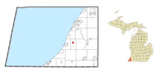
Baroda is a village in Berrien County in the U.S. state of Michigan. The population was 873 at the 2010 census. The village is within Baroda Township.
Shoreham is a village in Berrien County in the U.S. state of Michigan. The population was 844 at the 2020 census. The village is located within St. Joseph Charter Township on the shore of Lake Michigan, just south of the City of St. Joseph.
Grim Township is a civil township of Gladwin County in the U.S. state of Michigan. The population was 136 at the 2010 census.
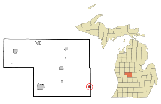
Reading is a city in Hillsdale County in the U.S. state of Michigan. The population was 1,095 at the 2020 census.
Lyons is a village in Ionia County in the U.S. state of Michigan. The population was 789 at the 2010 census. Most of the village is within Lyons Township. A small portion extends west into Ionia Township.
Isabella Township is a civil township of Isabella County in the U.S. state of Michigan. The population was 2,096 at the 2020 census.
Hudson Township is a civil township of Lenawee County in the U.S. state of Michigan. As of the 2000 census, the township population was 1,576. The city of Hudson borders the township on the west, but the two are administered autonomously.
Carson City is a city in Montcalm County of the U.S. state of Michigan. The population was 1,120 at the 2020 census.
Lakeview is a village in Cato Township in Montcalm County of the U.S. state of Michigan. The population was 1,024 at the 2020 census.
Pierson is a village in Montcalm County of the U.S. state of Michigan. The population was 229 at the 2020 census, up from 172 in 2010. The village is within Pierson Township.
Evart is a city in Osceola County in the U.S. state of Michigan. The population was 1,742 at the 2020 census. The city lies on the northern edge of Evart Township and is partially within neighboring Osceola Township, although the city is administered autonomously.
Carrollton Township is a civil township of Saginaw County in the U.S. state of Michigan. The population was 6,103 at the 2010 census. Established in 1866, Carrollton contains a full-time police department, fire department, parks and recreation services, as well as its own public school system, Carrollton Public Schools. Along with being located on the Saginaw River, Carrollton offers close access to shopping malls, medical facilities, Saginaw Valley State University, and I-75.
Zilwaukee Township is a civil township of Saginaw County in the U.S. state of Michigan. The population was 62 at the 2020 census, which ranks the township the fourth-least populated municipality in the state of Michigan after Pointe Aux Barques Township, Grand Island Township, and West Branch Township.
Morrice is a village located in Shiawassee County in the U.S. state of Michigan. The population was 927 at the 2010 census. The village is located within Perry Township. The center of population of Michigan is located near Morrice.
Centreville is a village in the U.S. state of Michigan and the county seat of St. Joseph County. The population was 1,425 at the 2010 census.
Woodhaven is a city in Wayne County, Michigan, United States. As of the 2010 census, the city had a population of 12,875. It is part of a collection of communities known as Downriver.
Follansbee is a city in Brooke County, West Virginia, United States, located along the Ohio River. The population was 2,853 at the 2020 census, a decrease from 2,986 at the 2010 census. It is part of the Weirton–Steubenville metropolitan area. The city was named after the Follansbee brothers, the proprietors of a local steel mill.
Ovid is a city in the U.S. state of Michigan. Nearly all of the city is located within Clinton County with only a very small portion extending east into Shiawassee County. The population was 1,603 at the 2010 census.