Åsen, Oslo

Last updated

Coordinates: 59°56′26.04″N10°46′30.66″E / 59.9405667°N 10.7751833°E / 59.9405667; 10.7751833

Geographic coordinate system Coordinate system

A geographic coordinate system is a coordinate system that enables every location on Earth to be specified by a set of numbers, letters or symbols. The coordinates are often chosen such that one of the numbers represents a vertical position and two or three of the numbers represent a horizontal position; alternatively, a geographic position may be expressed in a combined three-dimensional Cartesian vector. A common choice of coordinates is latitude, longitude and elevation. To specify a location on a plane requires a map projection.

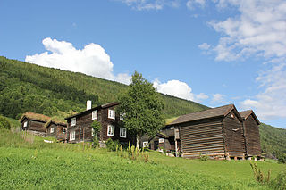
Buildings at Nordre Asen (Northern Asen). Nordre Asen.JPG
Buildings at Nordre Åsen (Northern Åsen).

Åsen is a neighborhood divided between the boroughs of Sagene and Nordre Aker in Oslo, Norway.

Sagene District in Norway

Sagene is a district of the city of Oslo, Norway. The area became part of the city of Oslo in 1859. The name Sagene itself is the plural of the Norwegian word for "saw", reflecting all the old industrial mechanical saws powered by the river Akerselva in this area in the 19th and early 20th centuries.

Nordre Aker District in Norway

Nordre Aker is a district of the city of Oslo, Norway.

Oslo Place in Østlandet, Norway

Oslo is the capital and most populous city of Norway. It constitutes both a county and a municipality. Founded in the year 1040 as Ánslo, and established as a kaupstad or trading place in 1048 by Harald Hardrada, the city was elevated to a bishopric in 1070 and a capital under Haakon V of Norway around 1300. Personal unions with Denmark from 1397 to 1523 and again from 1536 to 1814 reduced its influence, and with Sweden from 1814 to 1905 it functioned as a co-official capital. After being destroyed by a fire in 1624, during the reign of King Christian IV, a new city was built closer to Akershus Fortress and named Christiania in the king's honour. It was established as a municipality (formannskapsdistrikt) on 1 January 1838. The city's name was spelled Kristiania between 1877 and 1897 by state and municipal authorities. In 1925 the city was renamed Oslo.

The neighbourhood is named after the old farm Åsen [1] (Norse Ósin, from originally *Ásvin). The first element is áss m 'mountain ridge'[ dubious ] (here referring to Grefsenåsen), the last element is vin f 'meadow'.

Grefsenåsen mountain in Norway

Grefsenåsen is a hill in Lillomarka in Oslo, Norway. The height is 377 meter.

Meadow field vegetated primarily by grass and other non-woody plants (grassland)

A meadow is a field habitat vegetated by grass and other non-woody plants (grassland).

The name is often misunderstood as åsen, the finite form of ås (the modern Norwegian form of áss), and is then wrongly pronounced with accent 1 - but the correct pronunciation is with accent 2.

Åsen farm was owned by the Catholic Church until the Reformation, when it came on private hands. It was split in three in 1810. When the Gjøvik Line was constructed to run through Åsen's farmlands, and it was parceled out to residencies. The municipality erected residential complexes there in the 1920s and 1930s, supplemented by blocks in the late 1940s. [1]
Gjøvik Line railway line

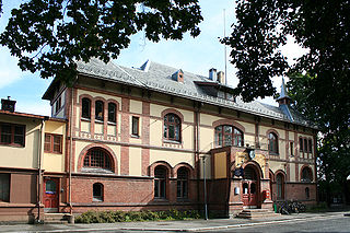
The Gjøvik Line is a Norwegian railway line between Oslo and Gjøvik. It was originally named the North Line (Nordbanen) and ran between Grefsen and Røykenvik. The line was completed to Gjøvik in 1902. The Gjøvik Line was one of the first lines of the Norwegian railway system which was to be contracted on public service obligation, but it was the state owned Norges Statsbaner which won it through its subsidiary NSB Anbud.

At Nordre Åsen there is a sports field, which is a home field of Skeid Fotball and Skeid Bandy.

Skeid Fotball association football club

Skeid Fotball is a Norwegian football club from Oslo that currently plays in 1. divisjon, the second tier of the Norwegian football league system. Its current home field is Nordre Åsen, after the club stopped playing at Bislett after the 2012 season. In past decades it has gained a reputation as a talent factory for the larger clubs in Norwegian football, and it has produced several players for the national team such as Daniel Braaten, Daniel Fredheim Holm, Omar Elabdellaoui and Mohammed Abdellaoue. Other notable players include Paul Miller. Skeid played in 1. divisjon in 2009 after a short stint in the 2. divisjon. They finished champions of the Second Group of 2. divisjon in 2008. However, Skeid relegated again to 2. divisjon at end of 2009 season in 16th and last position despite a good start. In 2018, Skeid won 2. divisjon group 1 and was promoted to the 1. divisjon.
Related Research Articles

Fornebu Village in Østlandet, Norway

Fornebu is a peninsular area in the suburban municipality of Bærum in Norway, bordering western parts of Oslo.

Torshov

Torshov is a neighborhood north of Grünerløkka and Lilleborg in the borough Sagene in Oslo, Norway. Oslo Tramway provides connections with lines running between Majorstuen and Kjelsås. Vogts gate serves as the main street of the neighborhood. Along Vogts gate are several coffee shops, restaurants and cafes. The Torshov public school was built in 1878. Torshov was separated from Sagene as a separate congregation in 1930. The local sports club is Skeid Fotball.

Sinsen neighborhood in Oslo

Sinsen is a mixed residential and commercial area in Grünerløkka borough of Oslo, Norway. The westernmost part of Sinsen is part of the borough Nordre Aker.

Blindern

Blindern is the main campus of the University of Oslo, located in Nordre Aker in Oslo, Norway.

Akerselva river in Oslo, Norway

Akerselva or Akerselven is a river which flows through Oslo. It starts at Maridalsvannet in Oslomarka, and follows the urban areas Nordre Aker, Sagene, Grünerløkka, Oslo centre and Grønland, whereby it finally ends at Paulsenkaien and Oset in Bjørvika. The river is considered to be a part of the Nordmarkvassdraget, and has the watercourse number 006.Z. The entire river is about 8.2 kilometres (5.1 mi) long, and has a difference in elevation between source and mouth of approximately 149 metres (489 ft).

Jostedal Village and Former Municipality in Sogn og Fjordane, Norway

Jostedal is a village and a former municipality in Sogn og Fjordane county in Norway. It is located in the northern part of the present-day municipality of Luster, about 22 kilometres (14 mi) north of Gaupne. The village of Jostedal currently has around 410 inhabitants (2008).

Nydalen neighbourhood in Oslo, Norway

Nydalen is a neighbourhood in the Nordre Aker borough in northern Oslo, Norway.

Aurskog human settlement

Aurskog is a former municipality in Akershus county, Norway. The administrative centre was Aursmoen.

Aker is a geographic area within today's Oslo and a former independent municipality in Akershus, Norway. The name originally belonged to a farm which was located near the current Old Aker Church. The church in turn became the source of the name of the parish, the Akershus Fortress, the municipality and the entire county of Akershus, as well as numerous institutions within this area. The name remains in use in two districts of Oslo, Vestre Aker and Nordre Aker.

Results from Norwegian football in 1965.

Storo, Norway

Storo is a neighborhood in the boroughs of Sagene and Nordre Aker in Oslo, Norway. It is located east of Nydalen, south-west of Grefsen and north of Sandaker. In addition to block housing, it hosts the Storo Storsenter shopping center. There are also many car dealerships in the area. The Ring 3 trunk road runs through Storo, and the area is served by Storo station on the Oslo T-bane and Oslo Tramway.

Results from Norwegian football in 1967.

Sogn District in Sogn og Fjordane, Norway

Sogn is a traditional district in Western Norway (Vestlandet). It is located in the county of Sogn og Fjordane, surrounding the Sognefjord, the largest/longest fjord in Norway. The district of Sogn consists of the municipalities of Aurland, Balestrand, Hyllestad, Høyanger, Gulen, Leikanger, Luster, Lærdal, Sogndal, Solund, Vik, and Årdal. The district covers 10,675 square kilometres (4,122 sq mi) and contains about 35% of the county's population. The largest urban area in Sogn is the village of Sogndalsfjøra, with 3,455 residents. The second largest urban area is the village Øvre Årdal, with 3,397 people.

Disen

Disen is a neighborhood divided between the boroughs of Bjerke and Nordre Aker in Oslo, Norway.

Håkås

Håkås, formerly spelled Haagaas and Haakaas, is a hill and an area near the lake Øyeren in Båstad in Trøgstad, Østfold, Norway, 25 kilometres southeast of Oslo. It is also the name of three neighbouring farms in the immediate vicinity of the hill. In 2016 the Håkås nature reserve was established by the King-in-Council; consisting of the Håkås forests near Øyeren, it was fully protected due to its importance to biodiversity.

Nordre Ekre Norwegian farm with log houses

Nordre Ekre is a farm in the lower part of the valley Heidal in Sel municipality, Norway. Some of the buildings on the farm date back from the 18th century. In 2004 the then owners were awarded the Norwegian Heritage sign of quality, Olavsrosa, for outreach activities and sustainable use of Norwegian heritage. Nordre Ekre has been an agritourism farm since 1995, in the early years based mainly on self-catering.

References

  1. 1 2 "Åsen". Store norske leksikon (in Norwegian). Retrieved 29 January 2010.