
Taray District is one of eight districts of the Calca Province in the Cusco Region in Peru. Its seat is Taray. The town lies near Pisac, southwest of it, at a stream called Pawayuq (Pahuayoc), an affluent of Willkanuta River.
Kimsaqucha is a group of lakes in Peru located in the Cusco Region, Calca Province, Pisac District. The lakes lie in the north of the district, northeast of Pisac, in the community of Paru Paru.
Ñusta Hispana, Ñusta Ispanan, previously known as Chuquipalta is an archaeological site in Peru. It is located at Vilcabamba, La Convención Province, Cusco Region.
Chawaytiri is an archaeological site with rock paintings in Peru. It is situated in the Cusco Region, Calca Province, Pisac District, near the village Chawaytiri. The principal section with paintings predominantly showing llamas is named Llamachayuq Qaqa or Chawaytiri. It lies on the slope of the mountain Muruwiksa (Moro-Wicsa, Morowiqsa, Morro Huicsa). The other sections are named Wamanwachana, Kawituyuq (Cahuituyoc), P'allqapata (Pallcapata), Musuqllaqta (Mosoqllaqta), Misaqaqa and Qaqa.
Llamayuq is an archaeological site with tombs and rock paintings in Peru. It is situated in the Cusco Region, Calca Province, Calca District. The site lies at a height of about 4,000 metres (13,123 ft) on the slope of Llamayuq Q'asa, also known as Qucha Quyllur, in a valley called Wakan Wayq'u (Waqhanhuayq’o).

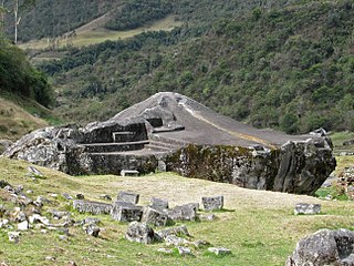
Inti Watana or Intiwatana (Quechua) is an archaeological site in Peru. It lies in the Cusco Region, Calca Province, Pisac District.

Parorjo is a mountain in the Urubamba mountain range in the Andes of Peru. It is situated in the Cusco Region, Calca Province, Lares District. Its summit is 4,891 m (16,047 ft) high. Parorjo is situated at the Lares trek north of Chicón and Sirihuani and west of Pucaorjo. One of the nearest populated places is Quishuarani. There is a small lake at its feet named Parococha.
Machu Kuntur Sinqa or Machu Kuntur Sankha is a mountain in the Cusco Region in Peru, about 4,200 metres (13,780 ft) high. It is situated in the Calca Province, on the border of the districts Pisac and San Salvador. Machu Kuntur Sinqa lies on the right bank of the Willkanuta River, near the archaeological park of Pisac.
Condorhuachana is a 5,073-metre-high (16,644 ft) mountain in the Urubamba mountain range in the Andes of Peru. It is located in the Cusco Region, Calca Province, Calca District, north of the Vilcanota River. Condorhuachana is situated northeast of Huamanchoque, southeast of Sirihuani and Sahuasiray, and southwest of Ccerayoc.

Huamanchoque is a 5,156-metre-high (16,916 ft) mountain in the Urubamba mountain range in the Andes of Peru. It is located in the Cusco Region, Calca Province, Calca District, north of the Vilcanota River. Huamanchoque lies at the Cancha Cancha valley where the Lares trek route passes by. It is situated south of Canchacanchajasa, southwest of Sahuasiray and Cóndorhuachana, and north of a lower peak named Cóndorhuachana. One of the nearest towns is Huayllabamba.

Canchacanchajasa is a 4,987-metre-high (16,362 ft) mountain in the Urubamba mountain range in the Andes of Peru. It is located in the Cusco Region, Calca Province, Calca District, north of the Urubamba River. Canchacanchajasa is situated southeast of Sirihuani, north of Cóndorhuachana and Huamanchoque and southwest of Sahuasiray. It lies in the upper part of the Cancha Cancha valley (kancha kancha) at the Lares trek.
Ichhunayuq is a mountain in the Andes of Peru, about 4,200 metres (13,780 ft) high. It is located in the Cusco Region, Calca Province, on the border of the districts of Coya and Pisac. Ichhunayuq lies at the archaeological site of Písac, northwest of the town.
Llamayojcasa, also known as Qochaqollur, is a mountain in the eastern extensions of the Urubamba mountain range in the Andes of Peru, about 4,600 m (15,092 ft) high. It is located in the Cusco Region, Calca Province, Calca District. It lies southeast of Ccerayoc. This is where the archaeological site of Llamayuq is situated.
Wallwa Qhata is a mountain in the Cusco Region in Peru, about 4,000 metres (13,123 ft) high. It is situated in the Calca Province, San Salvador District. Wallwa Qhata lies on the right bank of the Willkanuta River. The village of Wallwa (Huallhua) is situated at its feet.
Qhiwar is a mountain in the Cusco Region in Peru, about 4,400 metres (14,436 ft) high. It is situated in the Calca Province, San Salvador District. Qhiwar lies between Hatun Punta in the east and Wallwa Qhata in the southwest.
Coscojahuarina is a mountain in the eastern extensions of the Urubamba mountain range in the Andes of Peru, about 4,600 m (15,100 ft) high. It is located in the Cusco Region, Calca Province, Calca District. It lies southeast of Huamanchoque and Pitusiray.
Maquimaquiyoc is a mountain in the eastern extensions of the Urubamba mountain range in the Andes of Peru, about 4,200 m (13,800 ft) high. It is located in the Cusco Region, Calca Province, Calca District. It lies east of Coscojahuarina and southeast of Huamanchoque and Pitusiray.
Coscojahuarina is a 4,623-metre-high (15,167 ft) mountain in the eastern extensions of the Urubamba mountain range in the Andes of Peru It is located in the Cusco Region, Calca Province, Calca District. It lies south of Llamayojcasa and west of the village of Totora.
Challhuacocha is a lake in the Cusco Region in Peru. It is situated in the Calca Province, Pisac District.


