Čreta, Hoče–Slivnica

Last updated
Čreta
Slovenia location map.svg
Red pog.svg
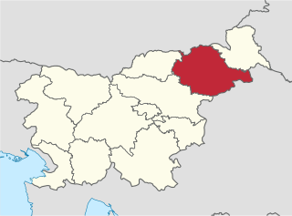
Čreta
Location in Slovenia
Coordinates: 46°28′26.65″N15°38′29.03″E / 46.4740694°N 15.6413972°E / 46.4740694; 15.6413972 Coordinates: 46°28′26.65″N15°38′29.03″E / 46.4740694°N 15.6413972°E / 46.4740694; 15.6413972
Country Flag of Slovenia.svg Slovenia
Traditional region Styria
Statistical region Drava
Municipality Hoče–Slivnica
Area
  Total3.52 km2 (1.36 sq mi)
Elevation
300 m (1,000 ft)
Population
(2002)
  Total294
[1]

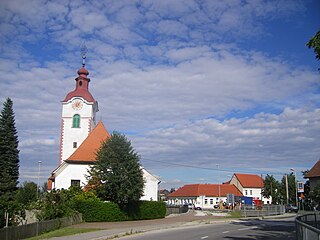
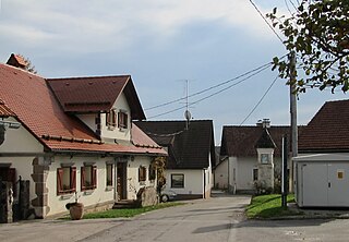
Čreta (pronounced  [ˈtʃɾeːta] ) is a settlement in the Municipality of Hoče–Slivnica in northeastern Slovenia. It lies in the eastern foothills of the Pohorje Hills south of Maribor. The area is part of the traditional region of Styria. The municipality is now included in the Drava Statistical Region. [2]

Slovenia republic in Central Europe

Slovenia, officially the Republic of Slovenia, is a sovereign state located in southern Central Europe at a crossroads of important European cultural and trade routes. It is bordered by Italy to the west, Austria to the north, Hungary to the northeast, Croatia to the southeast, and the Adriatic Sea to the southwest. It covers 20,273 square kilometers (7,827 sq mi) and has a population of 2.07 million. One of the successor states of the former Yugoslavia, Slovenia is a parliamentary republic and a member of the United Nations, of the European Union, and of NATO. The capital and largest city is Ljubljana.

Pohorje mountain range

Pohorje, also known as the Pohorje Massif or the Pohorje Mountains, is a mostly wooded, medium-high mountain range south of the Drava River in northeastern Slovenia. According to the traditional AVE classification it belongs to the Southern Limestone Alps. Geologically, it forms part of the Central Alps and features silicate metamorphic and igneous rock. Pohorje is sparsely populated with dispersed villages. There are also some ski resorts.

Maribor City in City Municipality of Maribor, Slovenia

Maribor is the second-largest city in Slovenia and the largest city of the traditional region of Lower Styria. It is also the seat of the City Municipality of Maribor.

An Iron Age and Roman-period hill fort with its associated burial ground with around 35 burial mounds have been identified near the settlement. [3]

The Iron Age is the final epoch of the three-age system, preceded by the Stone Age (Neolithic) and the Bronze Age. It is an archaeological era in the prehistory and protohistory of Europe and the Ancient Near East, and by analogy also used of other parts of the Old World. The three-age system was introduced in the first half of the 19th century for the archaeology of Europe in particular, and by the later 19th century expanded to the archaeology of the Ancient Near East. Its name harks back to the mythological "Ages of Man" of Hesiod. As an archaeological era it was first introduced for Scandinavia by Christian Jürgensen Thomsen in the 1830s. By the 1860s, it was embraced as a useful division of the "earliest history of mankind" in general and began to be applied in Assyriology. The development of the now-conventional periodization in the archaeology of the Ancient Near East was developed in the 1920s to 1930s. As its name suggests, Iron Age technology is characterized by the production of tools and weaponry by ferrous metallurgy (ironworking), more specifically from carbon steel.

Ancient Rome History of Rome from the 8th-century BC to the 5th-century

In historiography, ancient Rome is Roman civilization from the founding of the city of Rome in the 8th century BC to the collapse of the Western Roman Empire in the 5th century AD, encompassing the Roman Kingdom, Roman Republic and Roman Empire until the fall of the western empire. The civilization began as an Italic settlement in the Italian peninsula, dating from the 8th century BC, that grew into the city of Rome and which subsequently gave its name to the empire over which it ruled and to the widespread civilisation the empire developed. The Roman empire expanded to become one of the largest empires in the ancient world, though still ruled from the city, with an estimated 50 to 90 million inhabitants and covering 5.0 million square kilometres at its height in AD 117.

Cemetery Place of burial

A cemetery or graveyard is a place where the remains of dead people are buried or otherwise interred. The word cemetery implies that the land is specifically designated as a burial ground and originally applied to the Roman catacombs. The term graveyard is often used interchangeably with cemetery, but a graveyard primarily refers to a burial ground within a churchyard.

Related Research Articles

Municipality of Hoče-Slivnica Municipality in Slovenia

The Municipality of Hoče–Slivnica is a municipality south of Maribor in northeastern Slovenia. Its administrative centre is in Spodnje Hoče.

Slivnica or Slivnitsa may refer to

Drava Statistical Region Statistical region in 41

The Drava Statistical Region is a statistical region in Slovenia. The largest town in the region is Maribor. Its name comes from the Drava River and includes land on both banks along its course through Slovenia as well as the Pohorje mountains in the northeast of the region. The Drava is used for the production of hydroelectricity and the fertile land around it is used for agriculture. The share of job vacancies in all available jobs is among the highest in Slovenia and the region has a positive net migration rate but a very high natural decrease, which means an overall decrease in the population.

Spodnje Hoče Place in Styria, Slovenia

Spodnje Hoče is a settlement in and the administrative centre of the Municipality of Hoče–Slivnica in northeastern Slovenia. It lies below the eastern Pohorje Hills on the edge of the flatlands on the right bank of the Drava River south of Maribor. The area is part of the traditional region of Styria. The municipality is now included in the Drava Statistical Region.

Slivnica pri Mariboru Place in Styria, Slovenia

Slivnica pri Mariboru is a settlement in the Municipality of Hoče–Slivnica in northeastern Slovenia. It lies under the eastern Pohorje Hills on the edge of the flatlands on the right bank of the Drava River south of Maribor. The A1 Motorway runs through the settlement and a major interchange with the A4 motorway is located just north of the settlement. The area is part of the traditional region of Lower Styria. The municipality is now included in the Drava Statistical Region.

Bohova, Hoče–Slivnica Place in Styria, Slovenia

Bohova is a settlement in the Municipality of Hoče–Slivnica south of Maribor in northeastern Slovenia. The area is part of the traditional region of Styria. The municipality is now included in the Drava Statistical Region.

Hočko Pohorje in Styria, Slovenia

Hočko Pohorje is a settlement in the Municipality of Hoče-Slivnica in northeastern Slovenia. It lies in the eastern Pohorje Hills south of Maribor. The area is part of the traditional region of Styria. The municipality is now included in the Drava Statistical Region.

Hotinja Vas Place in Styria, Slovenia

Hotinja Vas is a village in the Municipality of Hoče–Slivnica in northeastern Slovenia. It lies on the edge of the flatlands on the right bank of the Drava River south of Maribor. Traditionally the area was part of the Styria region. The municipality is now included in the Drava Statistical Region.

Orehova vas Place in Styria, Slovenia

Orehova Vas is a settlement in the Municipality of Hoče–Slivnica in northeastern Slovenia. It lies on the edge of the flatlands on the right bank of the Drava River south of Maribor. The area is part of the traditional region of Styria. The municipality is now included in the Drava Statistical Region.

Pivola in Styria, Slovenia

Pivola is a settlement in the Municipality of Hoče–Slivnica in northeastern Slovenia. It lies on the eastern edge of the Pohorje Hills south of Maribor. The municipality is now included in the Drava Statistical Region.

Polana, Hoče–Slivnica in Styria, Slovenia

Polana is a settlement in the Municipality of Hoče–Slivnica in northeastern Slovenia. It lies in the eastern part of the Pohorje Hills. The area is part of the traditional region of Styria. The municipality is now included in the Drava Statistical Region.

Radizel Place in Styria, Slovenia

Radizel is a settlement in the Municipality of Hoče–Slivnica in northeastern Slovenia. It lies at the eastern foothills of the Pohorje range south of Maribor. Traditionally the area was part of Styria. The entire municipality is now included in the Drava Statistical Region.

Rogoza Place in Styria, Slovenia

Rogoza is a settlement in the Municipality of Hoče–Slivnica in northeastern Slovenia. It lies on the flatlands on the right bank of the Drava River between Spodnje Hoče and Miklavž na Dravskem Polju. The area is part of the traditional region of Styria. The municipality is now included in the Drava Statistical Region.

Slivniško Pohorje in Styria, Slovenia

Slivniško Pohorje is a settlement in the Pohorje Hills south of Maribor in northeastern Slovenia. It lies in the Municipality of Hoče–Slivnica, part of the traditional region of Styria. The municipality is now included in the Drava Statistical Region.

Zgornje Hoče in Styria, Slovenia

Zgornje Hoče is a settlement in the Municipality of Hoče–Slivnica in northeastern Slovenia. It lies at the eastern foothills of the Pohorje range south of Maribor. The area is part of the traditional region of Styria. The municipality is now included in the Drava Statistical Region.

Slivnica pri Celju in Styria, Slovenia

Slivnica pri Celju is a settlement in the Municipality of Šentjur in eastern Slovenia. The area is part of the historical Styria region. The municipality is now included in the Savinja Statistical Region.

Jelce in Styria, Slovenia

Jelce is a dispersed settlement in the hills south of Slivnica pri Celju in the Municipality of Šentjur in eastern Slovenia. Traditionally the area belonged to the Styria region. The municipality is now included in the Savinja Statistical Region.

Zgornja Slivnica Place in Lower Carniola, Slovenia

Zgornja Slivnica is a settlement in the Municipality of Grosuplje in central Slovenia. It lies in the hills north of Grosuplje and northeast of Šmarje-Sap and south of Mali Lipoglav in the historical region of Lower Carniola. The municipality is now included in the Central Slovenia Statistical Region.

Čreta may refer to several places in Slovenia:

Bohova may refer to:

References