
The maritime European exploration of Australia consisted of several waves of European seafarers who sailed the edges of the Australian continent. Dutch navigators were the first Europeans known to have explored and mapped the Australian coastline. The first documented encounter was that of Dutch navigator Willem Janszoon, in 1606. Dutch seafarers also visited the west and north coasts of the continent, as did French explorers.

Duyfken, also in the form Duifje or spelled Duifken or Duijfken, was a small ship built in the Dutch Republic. She was a fast, lightly armed ship probably intended for shallow water, small valuable cargoes, bringing messages, sending provisions, or privateering. The tonnage of Duyfken has been given as 25-30 lasten.

Cape Leeuwin is the most south-westerly mainland point of the Australian continent, in the state of Western Australia.
The Eendracht was an early 17th century Dutch wooden-hulled 700 tonne East Indiaman, launched in 1615 in the service of the Dutch East India Company (VOC). Its Dutch name means "concord", "unity" or "union", and was a common name given to Dutch ships of the period, from the motto of the Republic: Concordia res parvae crescunt . The ship was captained by Dirk Hartog when he made the second recorded landfall by a European on Australian soil, in 1616.

Denmark is a coastal town located on Wilson Inlet in the Great Southern region of Western Australia, 423 kilometres (263 mi) south-south-east of the state capital of Perth. At the 2016 census, Denmark had a population of 2,558; however, the population can be several times the base population during tourist seasons.

Pieter Nuyts or Nuijts was a Dutch explorer, diplomat and politician.
François Thijssen or Frans Thijsz was a Dutch-French explorer who explored the southern coast of Australia.

Eendrachtsland or Eendraghtsland is an obsolete geographical name for an area centred on the Gascoyne region of Western Australia. Between 1616 and 1644, during the European age of exploration, Eendraghtsland was also a name for the entire Australian mainland. From 1644, it and the surrounding areas were known as New Holland.
't Wapen van Hoorn was a 17th-century Dutch East India Company fluyt with a tonnage between 400 and 600, built in the Dutch Republic in 1619. During its second voyage it grounded on the west coast of Australia, making it about the tenth ship to make landfall on Australian soil, and following Tryall just a few weeks earlier only the second ship to be shipwrecked in Australian waters, albeit temporarily.
Vianen was a 17th-century Dutch East Indies Company sailing ship, used to transport cargo between Europe and the Indies. She was shipwrecked but refloated on her first voyage, and shipwrecked and sunk on her second. Built at Amsterdam in 1626, she had a gross tonnage of 400.

Leeuwin, was a Dutch galleon that discovered and mapped some of the southwest corner of Australia in March 1622. It was captained by Jan Fransz and was the seventh European ship to sight the continent.

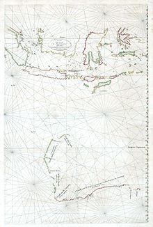
Caert van't Landt van d'Eendracht is a 1627 map by Hessel Gerritsz. One of the earliest maps of Australia, it shows what little was then known of the west coast, based on a number of voyages beginning with the 1616 voyage of Dirk Hartog, when he named Eendrachtsland after his ship.

St Peter Island is an island in the Nuyts Archipelago on the west coast of Eyre Peninsula in South Australia near Ceduna. It is the second largest island in South Australia and about 13 km (8.1 mi) long. It was one of the first parts of South Australia to be discovered and named by Europeans, along with St Francis Island, mapped by François Thijssen in 't Gulden Zeepaert in 1627.
St Francis Island is an island on the south coast of South Australia near Ceduna. It is part of the Nuyts Archipelago. It was one of the first parts of South Australia to be discovered and named by Europeans, along with St Peter Island, mapped by François Thijssen in 't Gulden Zeepaert in 1627.

The Nuyts Archipelago is an island group located in South Australia in the Great Australian Bight to the south of the town of Ceduna on the west coast of the Eyre Peninsula. It consisting of mostly granitic islands and reefs that provide breeding sites for Australian sea lions and support colonies of short-tailed shearwater. It also includes the island group known as the Isles of St Francis. All the islands with exception of a part of Evans Island, are located within the following protected areas: the Nuyts Archipelago Wilderness Protection Area and the Nuyts Archipelago Conservation Park.
The Pera and Arnhem were two ships from the Dutch East India Company that explored the north Australian coast in 1623. Arnhem Land is named after the Arnhem while the ship itself was named after the Dutch city Arnhem.
The Freycinet Map of 1811 is the first map of Australia to be published which shows the full outline of Australia. It was drawn by Louis de Freycinet and was an outcome of the Baudin expedition to Australia. It preceded the publication of Matthew Flinders' map of Australia, Terra Australis or Australia, by three years.
The Hundred of Wright is a cadastral hundred of County of Robinson in South Australia. It spans the west coast of the state at Venus Bay, 655 kilometres (407 mi) west of Adelaide.

The Hundred of Campbell is a cadastral hundred of the County of Robinson in South Australia.
