
Mission San Gabriel Arcángel is a Californian mission and historic landmark in San Gabriel, California. It was founded by the Spanish Empire on "The Feast of the Birth of Mary," September 8, 1771, as the fourth of what would become twenty-one Spanish missions in California. San Gabriel Arcángel was named after the Archangel Gabriel and often referred to as the "Godmother of the Pueblo of Los Angeles."

Mission La Purísima Concepción, or La Purísima Mission is a Spanish mission in Lompoc, California. It was established on December 8, 1787 by the Franciscan order. The original mission complex south of Lompoc was destroyed by an earthquake in 1812, and the mission was rebuilt at its present site a few miles to the northeast.

California is a U.S. state on the western coast of North America. Covering an area of 163,696 sq mi (423,970 km2), California is among the most geographically diverse states. The Sierra Nevada, the fertile farmlands of the Central Valley, and the arid Mojave Desert of the south are some of the geographic features of this U.S. state. It is home to some of the world's most exceptional trees: the tallest, most massive, and oldest. It is also home to both the highest and lowest points in the 48 contiguous states.

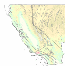
Southern California is a geographic and cultural region that generally comprises the southern portion of the U.S. state of California. It includes the Los Angeles metropolitan area as well as the Inland Empire. The region generally contains ten of California's 58 counties: Los Angeles, San Diego, Orange, Riverside, San Bernardino, Kern, Ventura, Santa Barbara, San Luis Obispo, and Imperial counties.

The San Andreas Fault is a continental right-lateral strike-slip transform fault that extends roughly 1,200 kilometers (750 mi) through the U.S. state of California. It forms part of the tectonic boundary between the Pacific Plate and the North American Plate. Traditionally, for scientific purposes, the fault has been classified into three main segments, each with different characteristics and a different degree of earthquake risk. The average slip rate along the entire fault ranges from 20 to 35 mm per year.
In seismology, an aftershock is a smaller earthquake that follows a larger earthquake, in the same area of the main shock, caused as the displaced crust adjusts to the effects of the main shock. Large earthquakes can have hundreds to thousands of instrumentally detectable aftershocks, which steadily decrease in magnitude and frequency according to a consistent pattern. In some earthquakes the main rupture happens in two or more steps, resulting in multiple main shocks. These are known as doublet earthquakes, and in general can be distinguished from aftershocks in having similar magnitudes and nearly identical seismic waveforms.

On October 17, 1989, at local time, the Loma Prieta earthquake occurred at the Central Coast of California. The shock was centered in The Forest of Nisene Marks State Park in Santa Cruz County, approximately 10 mi (16 km) northeast of Santa Cruz on a section of the San Andreas Fault System and was named for the nearby Loma Prieta Peak in the Santa Cruz Mountains. With an magnitude of 6.9 and a maximum Modified Mercalli intensity of IX (Violent), the shock was responsible for 63 deaths and 3,757 injuries. The Loma Prieta segment of the San Andreas Fault System had been relatively inactive since the 1906 San Francisco earthquake until two moderate foreshocks occurred in June 1988 and again in August 1989.

The San Fernando Valley, known locally as the Valley, is an urbanized valley in Los Angeles County, California. Situated northwards of the Los Angeles Basin, it comprises a large portion of Los Angeles, the incorporated cities of Burbank, Calabasas, Glendale, Hidden Hills and San Fernando, plus several unincorporated areas. The valley is the home of Warner Bros. Studios, Walt Disney Studios, and the Universal Studios Hollywood theme park.

Interstate 880 (I-880) is a north–south auxiliary Interstate Highway in the San Francisco Bay Area of Northern California. It runs from I-280 and State Route 17 (SR 17) in San Jose to I-80 and I-580 in Oakland, running parallel to the eastern shore of San Francisco Bay. For most of its route, I-880 is officially known as the Nimitz Freeway, after World War II fleet admiral Chester W. Nimitz, who retired to the Bay Area. The northernmost five miles (8.0 km) is also commonly referred to as the Cypress Freeway, after the former alignment of the freeway and its subsequent replacement.

The 1811–1812 New Madrid earthquakes were a series of intense intraplate earthquakes beginning with an initial earthquake of moment magnitude 7.2–8.2 on December 16, 1811, followed by a moment magnitude 7.4 aftershock on the same day. Two additional earthquakes of similar magnitude followed in January and February 1812. They remain the most powerful earthquakes to hit the contiguous United States east of the Rocky Mountains in recorded history. The earthquakes, as well as the seismic zone of their occurrence, were named for the Mississippi River town of New Madrid, then part of the Louisiana Territory and now within the U.S. state of Missouri.

The 1971 San Fernando earthquake occurred in the early morning of February 9 in the foothills of the San Gabriel Mountains in southern California. The unanticipated thrust earthquake had a magnitude of 6.5 on the scale and 6.6 on the scale, and a maximum Mercalli intensity of XI (Extreme). The event was one in a series that affected Los Angeles County during the late 20th century. Damage was locally severe in the northern San Fernando Valley and surface faulting was extensive to the south of the epicenter in the mountains, as well as urban settings along city streets and neighborhoods. Uplift and other effects affected private homes and businesses.

The New Madrid Seismic Zone (NMSZ), sometimes called the New Madrid Fault Line, is a major seismic zone and a prolific source of intraplate earthquakes in the Southern and Midwestern United States, stretching to the southwest from New Madrid, Missouri.
The 1857 Fort Tejon earthquake occurred at about 8:20 a.m. on January 9 in central and Southern California. One of the largest recorded earthquakes in the United States, with an estimated moment magnitude of 7.9, it ruptured the southern part of the San Andreas Fault for a length of about 225 miles, between Parkfield and Wrightwood.

Clifton Court Forebay is a reservoir in the San Joaquin River Delta region of eastern Contra Costa County, California, 17 mi (27 km) southwest of Stockton. The estuary region the forebay is located in is only 1m to 3m above mean sea level.
The San Cayetano Fault is an east-west trending thrust fault in Ventura County, Southern California. It stretches for 45 kilometers (28 mi), north of the city of Ventura, near the Topatopa Mountains, Piru, Fillmore, Santa Paula, Sulphur Springs, and Ojai.
Politana or Apolitana was the first Spanish settlement in the San Bernardino Valley of California. It was established as a mission chapel and supply station by the Mission San Gabriel in the a rancheria of the Guachama Indians that lived on the bluff that is now known as Bunker Hill, near Lytle Creek. Besides the Guachama, it was also at various times the home for colonists from New Mexico and Cahuilla people. Its most prominent landmark today is the St. Prophet Elias Greek Orthodox Church on Colton Avenue, just southwest of the Inland Center Mall, in San Bernardino, California.
The 1812 San Juan Capistrano earthquake, also known simply as the Capistrano earthquake or the Wrightwood earthquake, occurred on December 8 at in Alta California. At the time, this was a colonial territory of the Spanish Empire. Damage occurred at several of the missions in the region of Pueblo de Los Ángeles, including Mission San Gabriel Arcángel and Mission San Juan Capistrano, where 40 parishioners were killed during the collapse of a church at an early morning service. Tree ring and paleoseismic evidence show that there is a strong likelihood that the earthquake originated along the Mojave segment of the San Andreas Fault near Wrightwood, but other faults have been suggested as the cause.
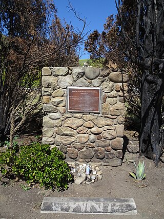
The Santa Gertrudis Asistencia, also known as the Santa Gertrudis Chapel, was an asistencia ("sub-mission") to the Mission San Buenaventura, part of the system of Spanish missions in Las Californias—Alta California. Built at an unknown date between 1792 and 1809, it was located approximately five miles from the main mission, inland and upstream along the Ventura River. The site was buried in 1968 by the construction of California State Route 33. Prior to the freeway's construction, archaeologists excavated and studied the site. A number of foundation stones were moved and used to create the Santa Gertrudis Asistencia Monument which was designated in 1970 as Ventura County Historic Landmark No. 11.

The 1812 Ventura earthquake occurred on the morning of December 21 at 11:00 Pacific Standard Time (PST). The 7.2 earthquake was assigned a with a maximum Modified Mercalli intensity of X (Extreme). The seismic shaking was followed by a tsunami that considerably damaged places in present-day Santa Barbara and Ventura County, California, which was at the time a territory of the Spanish Empire. One person was killed during the earthquake while another from an aftershock. The earthquake occurred while the region was recovering from another event on December 8.