
Solapur is a city located in the south-western region of the Indian state of Maharashtra, close to its border with Karnataka. Solapur is located on major highway, rail routes between Mumbai, Pune, Bangalore and Hyderabad, with a branch line to the cities of Kalaburagi and Vijayapura in the neighbouring state of Karnataka. Solapur International Airport is under construction. It is classified as A1 Tier and B-1 class city by House Rent Allowance (HRA) classification by the Government of India. It is the seventh biggest Metropolis Urban Agglomeration and 11th most populated city in Maharashtra as well as 43rd largest urban agglomeration and 49th most populous city in India.

Thane district is a district in the Konkan Division of Maharashtra, India. At the 2011 Census it was the most populated district in the country, with 11,060,148 inhabitants; however, in August 2014 the district was split into two with the creation of a new Palghar district, leaving the reduced Thane district with a 2011 Census population of 8,070,032. The headquarters of the district is the city of Thane. Other major cities in the district are Navi Mumbai, Kalyan-Dombivli, Mira-Bhayander, Bhiwandi, Ulhasnagar, Ambarnath, Badlapur, Murbad and Shahapur.
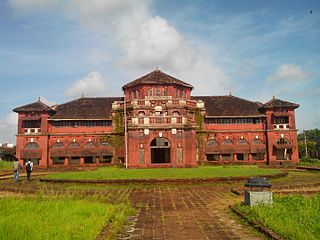
Ratnagiri is a port city on the Arabian Sea coast in Ratnagiri District in the southwestern part of Maharashtra, India. The district is a part of Konkan division of Maharashtra. The city is known for the Hapus or Alphonso mangoes. Ratnagiri is the birthplace of Indian independence activist Lokmanya Tilak. Thibaw, the last king of Burma, alongside his consort Supayalat and two infant daughters were exiled to a two-storied brick mansion in Ratnagiri. The building is now known as Thibaw Palace.
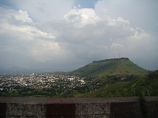
Satara is a city located in the Satara District of Maharashtra state of India, near the confluence of the river Krishna and its tributary, the Venna. The city was established in the 16th century and was the seat of the Chhatrapati of Maratha Empire, Shahu I. It is the headquarters of Satara Tehsil, as well as the Satara District. The city gets its name from the seven forts (Sat-Tara) which are around the city. The city is known as a Soldier's city as well as Pensioner's city.

Bijapur, officially known as Vijayapura, is the district headquarters of Bijapur district of the Karnataka state of India. It is also the headquarters for Bijapur Taluk. Bijapur city is well known for its historical monuments of architectural importance built during the rule of the Adil Shahi dynasty. It is also well known for the sports by the popular Karnataka premier league team as Bijapur Bulls. Bijapur is located 530 km (330 mi) northwest of the state capital Bangalore and about 550 km (340 mi) from Mumbai and 211 km (131 mi) north east of the city of Belgaum.

The Bombay Presidency or Bombay Province, also called Bombay and Sind (1843–1936), was an administrative subdivision (province) of British India, with its capital in the city that came up over the seven islands of Bombay. The first mainland territory was acquired in the Konkan region with the Treaty of Bassein (1802). Mahabaleswar was the summer capital.

Satara district is a district of Maharashtra state in western India with an area of 10,480 km2 (4,050 sq mi) and a population of 3,003,741 of which 14.17% were urban. Satara is the capital of the district and other major towns include Medha, Wai, Karad, Malkapur, Koregaon, Rahimatpur, Dahiwadi, Koynanagar, Phaltan, Lonand, Mahabaleshwar, Panchgani, Vaduj and Mhaswad. This district comes under Pune Administrative Division along with Pune, Sangli, Solapur and Kolhapur. The district of Pune bounds it to the north, Raigad bounds it to the north-west, Solapur the east, Sangli to the south, and Ratnagiri to the west.
Jalgaon is a district in the northern part of Maharashtra, India. The headquarters is the city of Jalgaon.

Bijapur district, officially known as Vijayapura district, is a district in the state of Karnataka in India. The city of Bijapur is the headquarters of the district, and is located 530 km northwest of Bangalore. Bijapur is well known for the great monuments of historical importance built during the Adil Shahi dynasty.

Sangli district is a district of Maharashtra state in India. Sangli city is the district headquarters. It is bordered by Satara district, Solapur district to the North, Karnataka state to South-East, by Kolhapur district to South-West and by narrow portion in East side to Ratnagiri district. It is present on the southern tip of Maharashtra.
Bombay Legislative Council was the legislature of the Bombay Province and later the upper house of the bicameral legislature of Bombay Province in British India and the Indian state of Bombay.

The Doji bara famine of 1791–1792 in the Indian subcontinent was brought on by a major El Niño event lasting from 1789–1795 and producing prolonged droughts. Recorded by William Roxburgh, a surgeon with the British East India Company, in a series of pioneering meteorological observations, the El Niño event caused the failure of the South Asian monsoon for four consecutive years starting in 1789.

The Roman Catholic Diocese of Pune is a diocese located in the city of Pune in the Ecclesiastical province of Mumbai in India.
The Lonari caste are found chiefly in India regions of Bhusawal, Jalgaon, Dhule, Surat, Ahmednagar, Aurangabad, Khandesh, Nasik, Pune, Baramati, Indapur, Sangli, Satara, Solapur, Jalna, the Satara agency, and the southern Maratha country. The caste had a population of 19,222 in 1901, which included 9,672 males and 9,550 females. They are a caste of cement–makers and lime burners who were once believed to be Marathas & later formed themselves into a separate class by adopting the occupation of lime and charcoal makers /traders. Lonari's originally never had any caste reservations & belonged to general (open) category but later were granted a OBC status in mid 90's in state of Maharastra. In Belgaum district they are divided into Mith (salt) and Chuna (lime) Lonaris, who eat together but do not intermarry. In Ahmednagar, Poona, and Solapur district, they are divided into Lonari proper and Kadu, Akaramashe.mainly kshtriya lonaries are maratha but due to political influence and having good leader they decided to go in OBC cast when circular came also one important thing in current situation caste people situated all over india like Karnataka, Madhya Predesh, Gujarat, etc Their origin is from Maharastra from ancient time.
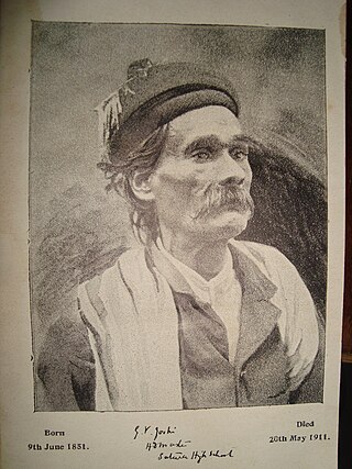
Ganesh Vyankatesh Joshi was an economist.
Gazetteer of the Bombay Presidency is a publication of the erstwhile British India first published in the year 1884 and printed at the Government Central Press, Bombay in 1884. Since the early 19th Century the English East India Company and later the British Empire annexed most of Western India and collectively named the provinces in Western India as Bombay Presidency.
This article gives a list of the territories of the dioceses of the Catholic Church in India.
The 6th Poona Divisional Area was an infantry division of the British Indian Army that formed part of the Indian Army during the First World War. It was formed in October 1914 to replace the original 6th (Poona) Division that had been mobilized in September 1914 for service in Mesopotamia. It was renamed as Poona Division in June 1917 and remained in India throughout the war. The division was redesignated as Poona District in 1920.
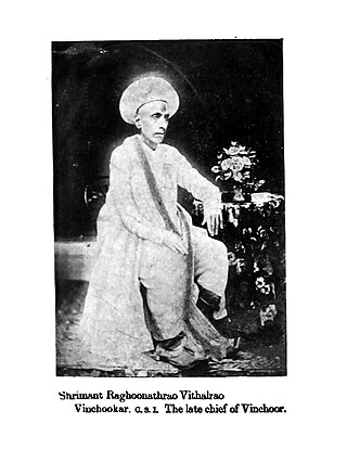
The Vinchurkar family is a prominent Maratha family of Nobles, Sardars, Patil, Jagirdars, Mankaris of Vinchur during Maratha Empire, East India Company and British Raj times.