
The Dwight D. Eisenhower National System of Interstate and Defense Highways, commonly known as the Interstate Highway System, is a network of controlled-access highways that forms part of the National Highway System in the United States. The system is named for President Dwight D. Eisenhower, who championed its formation. Construction was authorized by the Federal Aid Highway Act of 1956, and the original portion was completed 35 years later, although some urban routes were cancelled and never built. The network has since been extended. In 2016, it had a total length of 48,181 miles (77,540 km). As of 2016, about one-quarter of all vehicle miles driven in the country use the Interstate system. In 2006, the cost of construction was estimated at about $425 billion.
Interstate 17 (I-17) is an Interstate Highway located entirely within the U.S. state of Arizona. I-17's southern terminus lies within Phoenix, at Interstate 10, and its northern terminus is in Flagstaff, at Interstate 40. The majority of I-17 is known as the Arizona Veterans Highway. In the Phoenix metropolitan area, it is mostly known as the Black Canyon Freeway, however the southern 4.16 miles (6.69 km) is part of the Maricopa Freeway. The portion of the highway south of Cordes Lakes was built along the alignment of SR 69, while the northern part was built along old SR 79's alignment. I-17 is one of the most scenic Interstate Highways as it gains more than a mile in altitude between Phoenix at 1,117 feet (340 m) and Flagstaff at 7,000 feet (2,100 m). The highway features several scenic view exits along its route that overlook the many mountains and valleys found in northern Arizona.
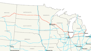
Interstate 94 (I-94) is an east–west Interstate Highway connecting the Great Lakes and northern Great Plains regions of the United States. Its western terminus is in Billings, Montana, at a junction with I-90; its eastern terminus is in Port Huron, Michigan, where it meets with I-69 and crosses the Blue Water Bridge into Sarnia, Ontario, Canada, where the route becomes Ontario Highway 402. It thus lies along the primary overland route from Seattle to Toronto, and is the only east–west Interstate highway to form a direct connection into Canada.
Interstate 71 (I-71) is a north-south Interstate Highway in the Great Lakes/Midwestern and Southeastern region of the United States. Its southern terminus is at an interchange with Interstate 64 and Interstate 65 in Louisville, Kentucky. Its northern terminus is at an interchange with Interstate 90 in Cleveland, Ohio. I-71 runs concurrently with Interstate 75 from a point about twenty miles (32 km) south of Cincinnati, Ohio into downtown Cincinnati. Almost three quarters of the route lies east of I-75, thereby putting it out of its proper place in the Interstate grid.
Interstate 495 (I-495) is an auxiliary route of I-95 in the U.S. state of Massachusetts, maintained by the Massachusetts Department of Transportation (MassDOT). Spanning 120.74 miles (194.31 km), it is the second-longest auxiliary route in the Interstate Highway System, ranking behind I-476 in Pennsylvania by a difference of roughly 11 miles (18 km).
State Route 523 is a short Washington state highway located on the city limits of Seattle, Shoreline and Lake Forest Park in King County. The road itself runs 2.45 miles (3.94 km) east from SR 99 past Interstate 5 (I-5) and ends at SR 522; the highway was first established in 1991, but the roadway from I-5 to 5th Avenue Northeast was once the northern section of Secondary State Highway 1J from 1937 until 1964 and later SR 513 from 1964 until 1991.

The local-express lane system is an arrangement of carriageways within a major highway where long distance traffic can use lanes with fewer interchanges compared to local traffic which use 'local' or 'collector' lanes that have access to all interchanges. This can also be called collector–distributor lanes within a single interchange. Where highway ramps between express and local/collector lanes cross over one another this is commonly known as braided ramps. One of the longest examples is Ontario Highway 401 between Etobicoke and Pickering in Canada.
Interstate 190 (I-190) is an intrastate Interstate Highway in the U.S. state of Illinois. I-190 runs west from I-90 to O'Hare International Airport. This is a distance of 3.07 miles (4.94 km). Interstate 190 is the westernmost leg of the Kennedy Expressway.
Interstate 194 (I-194) is a 3.4-mile-long (5.5 km), north–south freeway between downtown Battle Creek and I-94 in the southern portion of the city. The highway has been designated the Sojourner Truth Downtown Parkway by the state after the abolitionist Sojourner Truth, who was active in the Battle Creek area. Locals refer to the freeway by its semi-official nickname,"The Penetrator". I-194 is the only three-digit spur or loop route off I-94 in the state of Michigan and runs concurrently throughout its length with M-66, which continues both north and south from the termini of I-194. The freeway was initially opened in 1961 and completed in its current form in 1966. The highway was named in 1976 for Truth in honor of her local connections to the area.
The Bismarck Expressway is a state highway in Mandan and Bismarck, North Dakota, in the United States. It carries two unsigned highways: Interstate 194 (I-194) from its west end at exit 156 of I-94 to BL I-94 in Mandan, and North Dakota Highway 810 (ND 810) from BL I-94 in Mandan, around the south side of Bismarck back to BL I-94 in Bismarck. BL I-94 takes the designation from the end of ND 810 to the designation's eastern terminus at I-94 and US 83. The portion in Mandan, even where it is ND 810, is a freeway; once it crosses the Missouri River into Bismarck, it becomes a four-lane surface road.
Minnesota State Highway 194 is a highway in northeast Minnesota, which runs from its intersection with U.S. Highway 2 in Solway Township and continues east to its eastern terminus at its Mesaba Avenue interchange with Interstate Highway 35 in downtown Duluth. For part of its route, it runs together with U.S. Highway 53.

State Route 194 is a primary state highway in the U.S. state of Virginia. The state highway runs 5.75 miles (9.25 km) from SR 166 north to U.S. Route 60 within the independent city of Norfolk. SR 194 is a major north–south thoroughfare in the eastern part of Norfolk.
Interstate 81 is an 854.89-mile-long (1,375.81 km) north–south Interstate Highway, stretching from Dandridge, Tennessee to Fisher's Landing, New York at the United States/Canadian border. In the state of Pennsylvania, I-81 runs for 232.63 miles (374.38 km) from the Maryland state line near Greencastle to the New York state line near Hallstead and is called the American Legion Memorial Highway. It is the longest north–south Interstate in Pennsylvania.
The New York State Department of Transportation (NYSDOT) is responsible for the establishment and classification of a state highway network which includes Interstate Highways, U.S. Highways, and state routes. U.S. and Interstate Highways are classified as state routes in New York; however, a letter is suffixed to the number of the route. As a result, there is apparent duplication between U.S. Routes, Interstate Highways and state routes.
Interstate 40 (I-40), a major east–west route of the Interstate Highway System, runs east–west through Albuquerque in the U.S. state of New Mexico. It is the direct replacement for the historic U.S. Highway 66 (US 66).
Highways in the United States are split into at least four different types of systems: Interstate Highways, U.S. Highways, state highways, and county highways. Highways are generally organized by a route number or letter. These designations are generally displayed along the route by means of a highway shield. Each system has its own unique shield design that will allow quick identification to which system the route belongs. Below is a list of the different highway shields used throughout the United States.
Interstate business routes are roads connecting a central or commercial district of a city or town with an Interstate bypass. These roads typically follow along local streets often along a former U.S. route or state highway that had been replaced by an Interstate. Interstate business route reassurance markers are signed as either loops or spurs using a green shield shaped and numbered like the shield of the parent Interstate highway.
