
The Borough of Runnymede is a local government district with borough status in Surrey, England. Its council is based in Addlestone and the borough also includes the towns of Chertsey and Egham. The borough is named after Runnymede, a water meadow on the banks of the River Thames near Egham, which is connected with the sealing of Magna Carta by King John in 1215.

Welwyn Hatfield is a local government district with borough status in the county of Hertfordshire, England. Its council is based in Welwyn Garden City. The borough borders Hertsmere, St Albans, North Hertfordshire, East Hertfordshire, Broxbourne, and the London Borough of Enfield.

Derbyshire Dales is a local government district in Derbyshire, England. The district was created in 1974 as West Derbyshire; the name was changed to Derbyshire Dales in 1987. The council is based in the town of Matlock, and the district also includes the towns of Ashbourne, Bakewell, Darley Dale and Wirksworth, as well as numerous villages and extensive rural areas. Much of the district is within the Peak District National Park.

South Derbyshire is a local government district in Derbyshire, England. The district covers the towns of Melbourne and Swadlincote as well as numerous villages and hamlets such as Hilton, Hatton, Etwall, Aston-on-Trent, Repton, Weston-on-Trent and Willington. About a third of the National Forest lies within the district.
Erewash is a local government district with borough status in Derbyshire, England. The borough is named after the River Erewash. The council has offices in both the borough's towns of Ilkeston and Long Eaton. The borough also includes several villages and surrounding rural areas. Some of the built-up areas in the east of the borough form part of the Nottingham Urban Area.
Ashfield is a local government district in Nottinghamshire, England. The council is based in Kirkby-in-Ashfield, but the largest town is neighbouring Sutton-in-Ashfield. The district also contains the town of Hucknall and a few villages. The district is mostly urban, with some of its settlements forming parts of both the Nottingham and Mansfield Urban Areas.

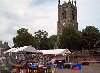
Newark and Sherwood is a local government district in Nottinghamshire, England. It is the largest district by area in the county. The council is based in Newark-on-Trent, the area's largest town. The district also includes the towns of Southwell and Ollerton along with a large rural area containing many villages. Much of the district lies within the ancient Sherwood Forest and there are also extensive forestry plantations in the area.

Rushmoor is a local government district with borough status in Hampshire, England. It covers the towns of Farnborough, where the council is based, and Aldershot.
Horsham is a local government district in West Sussex, England. It is named after the town of Horsham, which is its largest settlement and where the council is based. The district also includes the surrounding rural area and contains many villages, the largest of which are Southwater and Billingshurst. The district includes part of the South Downs National Park and part of the designated Area of Outstanding Natural Beauty of High Weald. At the 2021 census the district had a population of 147,487.
Winchester, or the City of Winchester, is a local government district with city status in Hampshire, England.

The Borough of Newcastle-under-Lyme is a local government district with borough status in Staffordshire, England.
Cannock Chase is a local government district in Staffordshire, England. It is named after and covers a large part of Cannock Chase, a designated Area of Outstanding Natural Beauty. The council is based in the town of Cannock. The district also contains the towns of Hednesford and Rugeley, as well as a number of villages and surrounding rural areas.

The Borough of Basildon is a local government district with borough status in Essex, England. The borough is named after its largest town, Basildon, where the council is based. The borough also includes the towns of Billericay and Wickford and surrounding rural areas.

Three Rivers is a local government district in south-west Hertfordshire, England. Its council is based in Rickmansworth. The district borders Hertsmere, Watford, St Albans, Dacorum, Buckinghamshire, and the London boroughs of Hillingdon and Harrow.
Cheshire County Council was the county council of Cheshire. Founded on 1 April 1889, it was officially dissolved on 31 March 2009, when it and its districts were superseded by two unitary authorities; Cheshire West and Chester and Cheshire East.

Wyre Forest is a local government district in Worcestershire, England. It is named after the ancient woodland of Wyre Forest. The largest town is Kidderminster, where the council is based. The district also includes the towns of Stourport-on-Severn and Bewdley, along with several villages and surrounding rural areas.

Sale was, from 1867 to 1974, a district in Cheshire, England. The district had in turn the status of local government district, urban district and municipal borough. Its area now forms part of the Metropolitan Borough of Trafford, Greater Manchester.

Watford Borough Council is the local authority for the Watford non-metropolitan district in the south-west of Hertfordshire, England. The council is based in the Town Hall on Hempstead Road. The council comprises 36 councillors plus a directly-elected mayor.

The first elections to Trafford Council were held on Thursday, 10 May 1973. This was a new council created to replace the following authorities: the Municipal Borough of Altrincham, the Municipal Borough of Sale, the Municipal Borough of Stretford, Bowdon Urban District, Hale Urban District, Urmston Urban District, and parts of Bucklow Rural District. This election would create the entire 63-member council, which would shadow its predecessor councils before taking over their functions on 1 April 1974, as specified in the Local Government Act 1972. Each 1st-placed candidate would serve a five-year term of office, expiring in 1978. Each 2nd-placed candidate would serve a three-year term of office, expiring in 1976. Each 3rd-placed candidate would serve a two-year term of office, expiring in 1975.
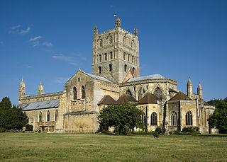
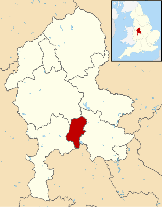
The Borough of Tewkesbury is a local government district with borough status in Gloucestershire, England. The borough is named after its largest town, Tewkesbury, which is where the council is based. The district also includes the town of Winchcombe and numerous villages including Bishops Cleeve, Ashchurch, Churchdown, Innsworth and Brockworth as well as other hamlets and surrounding rural areas. Parts of the district lie within the Cotswolds Area of Outstanding Natural Beauty.
