National Route 58 is a Japanese national highway connecting the capital cities Kagoshima and Naha of Kagoshima Prefecture and Okinawa Prefecture, respectively. With a total length of 884.4 kilometers (549.5 mi), it is the longest national highway in Japan, though it measures only 245.2 kilometers (152.4 mi) on land. The highway begins at an intersection with National Routes 3 and 10 in Kagoshima. From Kagoshima, it travels southwest along the first island chain that divides the Pacific Ocean from the East China Sea. From the north to the south, it has sections on the islands of Tanegashima, Amami Ōshima, and finally, Okinawa. On Okinawa it ends at an intersection with National Routes 330, 331, and 390 in Naha.
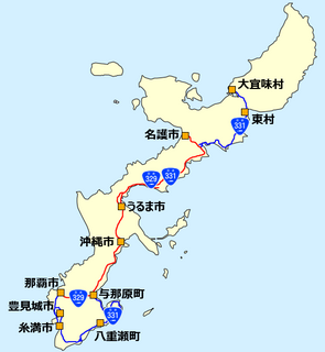
National Route 329 is a national highway of Japan connecting Nago, Okinawa and Naha, Okinawa in Japan, with a total length of 78.5 km (48.78 mi). The highway forks in Higashionna where the old 329 goes around the cliffs and the Ishikawa By-pass goes through the cliffs via the Ishikawa Tunnel (石川トンネル) and a bridge, all built in the early 1990s.
National Route 330 is a national highway of Japan connecting Okinawa, Okinawa and Naha, Okinawa in Japan, with a total length of 26.1 km (16.22 mi).
National Route 331 is a national highway of Japan connecting Itoman, Okinawa and Ōgimi, Okinawa in Japan, with a total length of 150.4 km (93.45 mi).

National Route 390 is both the southernmost and westernmost of the national highways of Japan. It connects Ishigaki, Okinawa on Ishigaki Island, to Miyako-jima, and Naha, Okinawa on Okinawa Island in Japan. Spanning the three islands by ferry, the highway has a total length of 58.2 kilometers (36.2 mi) on land and 552.2 kilometers (343.1 mi) when maritime distance is added.
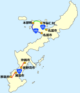
National Route 449 is a national highway of Japan connecting Motobu, Okinawa and Nago, Okinawa in Japan, with a total length of 20.3 km (12.61 mi).
National Route 505 is a national highway of Japan. The highway connects Motobu, Okinawa and Nago, Okinawa. It has a total length of 21.1 kilometres (13.1 mi).

Okinawa 1st district is a constituency of the House of Representatives in the Diet of Japan. It is located in Okinawa Prefecture and encompasses the city of Naha and parts of Shimajiri District. As of 2016, 270,872 eligible voters were registered in the district.
Okinawa currently sends 8 elected members to the Diet of Japan, 6 to the House of Representatives and 2 to the House of Councillors.
Okinawa 2nd district is a constituency of the House of Representatives in the Diet of Japan. It is located in Okinawa Prefecture and encompasses the cities of Urasoe and Ginowan, and Nakagami District. As of 2016, 288,070 eligible voters were registered in the district.
Okinawa 3rd district is a constituency of the House of Representatives in the Diet of Japan. It is located in Okinawa Prefecture and encompasses the cities of Nago, Okinawa, Uruma, Kunigami District and parts of Shimajiri District. As of 2016, 312,171 eligible voters were registered in the district.
Okinawa 4th district is a constituency of the House of Representatives in the Diet of Japan. It is located in Okinawa Prefecture and encompasses the cities of Miyakojima, Ishigaki, Itoman, Tomigusuku, Nanjō, the village of Tarama, Yaeyama District and parts of Shimajiri District. The district was formed after the 2002 national electoral district review assigned Okinawa an extra district. Constituency cities and towns in the 1st and 2nd district were reassigned to form the 4th district. As of 2016, 286,832 eligible voters were registered in the district.

The Naha Airport Expressway is an expressway on Okinawa Island in Okinawa Prefecture, Japan. The expressway has a length of 11.7 kilometres (7.3 mi). The Ministry of Land, Infrastructure, Transport and Tourism maintains most of the expressway, but the West Nippon Expressway Company is the owner and operator of a short section of the expressway at its eastern end. It is signed E58 as a spur route of the Okinawa Expressway under the "2016 Proposal for Realization of Expressway Numbering". It also carries the entire length of National Route 506.

