Related Research Articles

Landslides, also known as landslips, are several forms of mass wasting that may include a wide range of ground movements, such as rockfalls, deep-seated slope failures, mudflows, and debris flows. Landslides occur in a variety of environments, characterized by either steep or gentle slope gradients, from mountain ranges to coastal cliffs or even underwater, in which case they are called submarine landslides. Gravity is the primary driving force for a landslide to occur, but there are other factors affecting slope stability that produce specific conditions that make a slope prone to failure. In many cases, the landslide is triggered by a specific event, although this is not always identifiable.

A megatsunami is a very large wave created by a large, sudden displacement of material into a body of water.
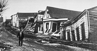
The 1960 Valdivia earthquake and tsunami or the Great Chilean earthquake on 22 May 1960 was the most powerful earthquake ever recorded. Various studies have placed it at 9.4–9.6 on the moment magnitude scale. It occurred in the afternoon, and lasted for approximately 10 minutes. The resulting tsunamis affected southern Chile, Hawaii, Japan, the Philippines, eastern New Zealand, southeast Australia, and the Aleutian Islands.
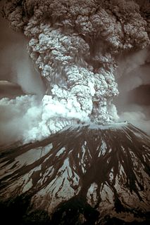
On March 27, 1980, a series of volcanic explosions and pyroclastic flows began at Mount St. Helens in Skamania County, Washington, United States. A series of phreatic blasts occurred from the summit and escalated until a major explosive eruption took place on May 18, 1980, at 8:32 AM. The eruption, which had a Volcanic Explosivity Index of 5, was the most significant to occur in the contiguous United States since the much smaller 1915 eruption of Lassen Peak in California. It has often been declared the most disastrous volcanic eruption in U.S. history.
The 1950 Assam–Tibet earthquake, also known as the Assam earthquake, occurred on 15 August and had a moment magnitude of 8.6. The epicentre was located in the Mishmi Hills in India, known in Chinese as the Qilinggong Mountains (祁灵公山), south of the Kangri Karpo and just east of the Himalayas in the North-East Frontier Agency part of Assam, India. This area, south of the McMahon Line and now known as Arunachal Pradesh, is today disputed between China and India. It is the strongest earthquake ever recorded on land.
There have been known various classifications of landslides. Broad definitions include forms of mass movement that narrower definitions exclude. For example, the McGraw-Hill Encyclopedia of Science and Technology distinguishes the following types of landslides:
The 1991 Racha earthquake occurred in the province of Racha, Georgia, at 9:12 UTC on 29 April. Centered on the districts of Oni and Ambrolauri on the southern foothills of the Greater Caucasus mountains, it killed 270, left approximately 100,000 homeless and caused severe damage, including to several medieval monuments. It had a magnitude of 7.0 and was the most powerful earthquake recorded in the Caucasus.
A landslide dam or barrier lake is the natural damming of a river by some kind of landslide, such as a debris flow, rock avalanche or volcanic eruption. If the damming landslide is caused by an earthquake, it may also be called a quake lake. Some landslide dams are as high as the largest existing artificial dam.
The 2002 Bou'in-Zahra earthquake occurred on 22 June 2002. The epicenter was near the city of Bou'in-Zahra in Qazvin Province, a region of northwestern Iran which is crossed by several major faults that is known for destructive earthquakes. The shock measured 6.5 on the Mwc scale, had a maximum Mercalli intensity of VIII (Severe), and was followed by more than 20 aftershocks. At least 230 people were killed and 1,500 more were injured.
The 2011 Sikkim earthquake occurred with a moment magnitude of 6.9 and was centered within the Kanchenjunga Conservation Area, near the border of Nepal and the Indian state of Sikkim, at 18:10 IST on Sunday, 18 September. The earthquake was felt across northeastern India, Nepal, Bhutan, Bangladesh and southern Tibet.

A major landslide occurred 4 miles (6.4 km) east of Oso, Washington, United States, on March 22, 2014, at 10:37 a.m. local time. A portion of an unstable hill collapsed, sending mud and debris to the south across the North Fork of the Stillaguamish River, engulfing a rural neighborhood, and covering an area of approximately 1 square mile (2.6 km2). Forty-three people were killed and 49 homes and other structures destroyed.
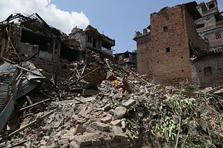
The April 2015 Nepal earthquake killed 8,964 people and injured 21,952 more. It occurred at on 25 April 2015, with a magnitude of 7.8Mw or 8.1Ms and a maximum Mercalli Intensity of X (Extreme). Its epicenter was east of Gorkha District at Barpak, Gorkha, and its hypocenter was at a depth of approximately 8.2 km (5.1 mi). It was the worst natural disaster to strike Nepal since the 1934 Nepal–Bihar earthquake. The ground motion recorded in the capital of Nepal was of low frequency, which, along with its occurrence at an hour where many people in rural areas were working outdoors, decreased the loss of property and human lives.
Landslides are triggered in Nepal due to a combination of steep mountains and unstable soils. The risk of the landslide is high in the monsoon season due to lubrication of soil in slope by moisture. Another important factor triggering the landslide is earthquakes. When landslide occurs near the river, it can block the river causing a damming effect. Damming could also occur due to rock-slides. Such dams are unstable and can cause flooding if not breached in controlled manner. Below is a list of dams formed due to landslides and their impacts in Nepal Annually, 593 natural disaster occurs in average and quite a few of them are related to the damming by landslides and about 13% of fatality is directly related to the landslide and Landslides Dammed Outburst Flood (LDOF).
The 1988 Lancang–Gengma earthquakes, also known as the 11.6 earthquakes by the Chinese media were a pair of devastating seismic events which struck Lancang and Gengma counties, Yunnan, near the border with Shan State, Burma in the Shan Plateau. The pair of earthquakes occurred thirteen minutes apart with the first registering 7.7 on the moment magnitude scale and second measuring 7.2 on the surface wave magnitude scale. The two earthquakes were assigned their maximum Mercalli intensities of X (Extreme) and IX (Violent) respectively. At least 939 people were killed and more than 7,700 were injured in 20 counties across five prefectures in Yunnan, making it the worst in the country since the 1976 Tangshan earthquake. Both earthquakes resulted in US $270 million in damages and economical losses. Moderately large aftershocks continued to rock the region, causing additional casualties and damages. Much information about the earthquakes and its devastation were hidden by the Chinese government as the country was going through major political and cultural revolutions at the time.
The 1988 Myanmar–India earthquake, also known as the Indo–Burma earthquake struck the Sagaing Region of Myanmar, about 30 kilometres (19 mi) from the border with India on 6 August at 7:06 am MMT with a moment magnitude (Mw ) of 7.3 or Richter magnitude (ML ) of 7.5. At least five people were killed, and more than 30 injured or missing as a result. Serious damage was reported in India and Bangladesh, while some minor damage occurred in Myanmar. The earthquake was reportedly felt in the Soviet Union.
In June 2021, the flood in Melamchi River caused damage in the Melamchi Bazar in Sindhupalchowk District of Nepal killing several locals and some foreigners

The area of Oeschinen Lake and Kander river valley in Switzerland have been subject of multiple large landslides during the Holocene. Both the number and timing of landslides is controversial, with the most recent estimates stating that the large Kander landslide occurred about 3,210 years ago and the smaller Oeschinen Lake landslide 2,300 years ago. Both may have been caused by earthquakes, and the latter landslide generated the Oeschinen Lake. More recent landslides have occurred, and unstable rock masses occur in the landslide area.
The Tsergo Ri landslide was a prehistoric landslide in the Nepalese Himalaya, which took place around 51,000±13,000 years ago, during the Last Glacial Period. During the collapse, a mass of rock of about 10–15 cubic kilometres (2.4–3.6 cu mi) detached from a previous mountain or ridge and descended with a speed of about 450 kilometres per hour (120 m/s); later, glaciers eroded almost the entire landslide mass. Previously weakened rocks may have contributed to the collapse, which was probably started by an earthquake.
References
- ↑ Yagi, Hiroshi; Maruo, Yuji; Saijo, Kiyoshi; Nakamura, Saburo (1990). "The Sept. 1988 large landslide in the vicinity of MCT, Darbang, Nepal". Landslides. 26 (4): 45–49. ISSN 0285-2926.
- ↑ Ibetsberger, Horst J; Weidinger, Johannes T (2000). "Role of extreme meteorological anomalies in initiating the Darbang Landslide, Dhaulagiri Himal, Western Nepal". Journal of Nepal Geological Society. 21: 35–40. ISSN 2676-1378.
- ↑ Upreti, Biswa Nath; Dhital, M.R. (1996). Landslide Studies and Management in Nepal. International Centre for Integrated Mountain Development. ISBN 9789291155026. Archived from the original on 24 March 2022. Retrieved 24 March 2022.
| | This Nepal-related article is a stub. You can help Wikipedia by expanding it. |