Related Research Articles
The economy of Tanzania is a lower-middle income economy that is centered around Manufacturing, Tourism, Agriculture, and financial services. Tanzania's economy has been transitioning from a planned economy to a market economy since 1985. Although total GDP has increased since these reforms began, GDP per capita dropped sharply at first, and only exceeded the pre-transition figure in around 2007.
Telecommunications in Tanzania include radio, television, fixed and mobile telephones, and the Internet available in mainland Tanzania and the semiautonomous Zanzibar archipelago.
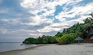
Mafia Island or Chole Shamba is an island of The Mafia Archipelago located in Mafia District in the southern Pwani Region of Tanzania across the Mafia Channel. The island is the third largest in Tanzanian ocean territory, but is not administratively included within the semi-autonomous region of Zanzibar, which has been politically separate since 1890. Mafia Island forms the largest part of Mafia District, one of the six administrative districts in the Pwani Region. As the Mafia Archipelago's main island, it's sometimes called Chole Shamba, meaning Chole farmlands in Swahili. This is in opposition to the historic settlement of Chole Mjini on Chole Island inside Mafia Bay. The island's population is over 65,000. The economy is based on fishing, subsistence agriculture and the market in Kilindoni. The island attracts some tourists, mainly scuba divers, birdwatchers, game fishermen, and people seeking relaxation.
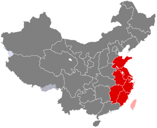
East China (华东) is a geographical region that covers the eastern coastal area of China.

Tanzania is administratively divided into thirty-one regions.

Dodoma Region is one of Tanzania's 31 administrative regions. The regional capital is the city of Dodoma. Dodoma is located in central Tanzania, bordered by Singida region to the west, Manyara region to the north, Iringa region to the south, and Morogoro region to the east. Dodoma region hosts the nation's capital city, where the legislative assembly of Bunge is based. Dodoma region also hosts one of the largest universities in Tanzania: University of Dodoma. The region is the home of the Tanzanian wine industry, which is the second largest wine industry on the continent after South Africa. According to the 2022 national census, the region had a population of 3,085,625; in the 2012 national census, the population was 2,083,588.

Pwani Region is one of Tanzania's 31 administrative regions. The word "Pwani" in Swahili means the "coast". The regional capital is the town of Kibaha. The region borders the Tanga Region to the north, Morogoro Region to the west, Lindi Region to the south, and surrounds Dar es Salaam Region to the east. The Indian Ocean also borders the region to its northeast and southeast. The region is home to Mafia Island, the Rufiji delta and Saadani National Park. The region is home to Bagamoyo town, a historical Swahili settlement, and the first colonial capital of German East Africa. According to the 2012 national census, the region had a population of 1,098,668, which was slightly lower than the pre-census projection of 1,110,917. From 2002 to 2012, the region's 2.2 percent average annual population growth rate was the seventeenth-highest in the country. It was also the 21st most densely populated region with 34 people per square kilometre., According to the 2022 census the population had nearly doubled to 2,024,947. The region is slightly larger than Belgium.

Kigoma Region is one of Tanzania's 31 administrative regions. The regional capital is the city of Kigoma. Kigoma Region borders Kagera Region, Geita Region, Katavi Region, Tabora Region, DRC and Burundi According to the 2012 national census, the region had a population of 2,127,930, which was higher than the pre-census projection of 1,971,332. For 2002–2012, the region's 2.4 percent average annual population growth rate was tied for the fourteenth highest in the country. It was also the sixteenth most densely populated region with 57 people per square kilometer. With a size of 45,066 square kilometres (17,400 sq mi), the region is slightly smaller than Estonia.

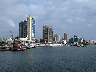
Kivukoni is an administrative ward of the Ilala Municipical Council of the Dar es Salaam Region in Tanzania. Kivikoni's name come from the Swahili word meaning "a crossing place". The ward is bordered by Upanga East ward to the west, Kisutu ward to the southwest, and Kigamboni ward across the Kivukoni channel. The ward covers an area of 2.387 km2 (0.922 sq mi). Kivukoni ward is one of the most important wards in the country, as it is home to the Ikulu, which is the home of the president of Tanzania. Kivukoni ward is also home to the National Museum of Tanzania. According to the 2022 census, the ward had a total population of 4,045.

Tabora Region is one of Tanzania's 31 administrative regions. The regional capital is the municipality of Tabora. The region is located in mid-western part of Tanzania. Tabora is bordered by Shinyanga to the north, Singida to the east, Mbeya and Songwe to the south. lastly, Katavi, Kigoma and Geita, border Tabora to the west. Tabora is by far the largest region in Tanzania by area. Most of the population in the region is concentrated in the north in Nzega district. According to the 2022 national census, Tabora Region had a population of 3,391,679.
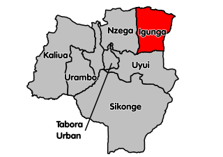
Igunga is one of the seven districts of the Tabora Region of Tanzania. It is bordered to the north by the Shinyanga Region, to the east by the Singida Region, to the south by the Uyui District and to the west by the Nzega District. Its administrative seat is the town of Igunga. Igunga is now divided by two Constituencys: Igunga Constituency and Manonga Constituency, whereby Manonga town is Choma Chankola. Igunga is the second district in production

Masasi is one of the six districts of the Mtwara Region of Tanzania. It is bordered to the north by the Lindi Region, to the east by the Newala District, to the south by the Ruvuma River and Mozambique and to the west by Nanyumbu District.
Tarime is a large town in northwestern Mara Region, Tanzania. The town is the location of the district capital of Tarime District. The main Tanzania-Kenyan border crossing in Sirari is less than 20km away from Tarime and can be reached by following the paved trunk road T4.

Tanzania is a country with many tourist attractions. Approximately 38 percent of Tanzania's land area is set aside in protected areas for conservation. There are 17 national parks, 29 game reserves, 40 controlled conservation areas and marine parks. Tanzania is also home to Mount Kilimanjaro, the highest point in Africa.

This article includes a list of China's historical gross domestic product (GDP) values, the market value of all final goods and services produced by a nation in a given year. The GDP dollar estimates presented here are either calculated at market or government official exchange rates (nominal), or derived from purchasing power parity (PPP) calculations. This article also includes historical GDP growth.

The National Bureau of Statistics is a branch of the Government of Tanzania which has the mandate to provide official statistics to the Government of Tanzania, business community and the public at large. It is based in Dodoma and obtains a wide range of economic, social and demographic statistics about the country. The bureau compiled data on every village in Tanzania for the censuses of 2002, 2012 and 2022, but also provides the results of the previous censuses of 1967, 1978 and 1988.

Wete District is one of two administrative districts of Pemba North Region in Tanzania. The district covers an area of 295 km2 (114 sq mi). The district is comparable in size to the land area of Maldives. The district has a water border to the east and west by the Indian Ocean. The district is bordered to the north by Micheweni District. The district seat (capital) is the town of Wete. According to the 2022 census, the district has a total population of 148,712.

Visitors to Tanzania must obtain either a visa on arrival or an e-Visa unless they are citizens of one of the visa-exempt countries or citizens who must obtain a visa from one of the Tanzanian diplomatic missions.

Songwe Region is one of Tanzania's 31 administrative regions. The region covers a land area of 27,656 km2 (10,678 sq mi). The region is comparable in size to the combined land area of the nation state of Haiti. Songwe Region borders the countries of Zambia and Malawi to the south: Tunduma is the main entry point into Zambia while Isongole is the main entry point into Malawi. Songwe also borders the Tanzanian regions of Rukwa and Katavi in the west, Tabora in the north, and Mbeya in the east. Lake Rukwa is a major body of water in the western part of the region. The region was created on 29 January 2016 from the western half of Mbeya Region. The regional capital is Vwawa. According to the 2022 national census, the region had a population of 1,344,687.
References
- ↑ "National Bureau of Statistics (NBS)". Government of Tanzania. Archived from the original on 2013-02-04. Retrieved October 24, 2010.
- ↑ "Tanzania: Agriculture Sample Census 2002". Open Micro Data Wordpress. 12 February 2010. Retrieved October 24, 2010.