Related Research Articles
The Marcopper mining disaster is one of the worst mining and environmental disasters in Philippine history. It occurred on March 24, 1996, on the Philippine island of Marinduque, a province of the Philippines located in the Mimaropa region. The disaster led to drastic reforms in the country's mining policy.
Kibi or Kyebi is a town located in the East Akim Municipal District, Eastern Region of Ghana. The population of Kibi is 11,677 people as of 2013.
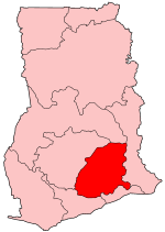
Atiwa is one of the constituencies represented in the Parliament of Ghana. It elects one Member of Parliament (MP) by the first past the post system of election. Atiwa is located in the Atiwa district of the Eastern Region of Ghana.
Akim Swedru is a town and the capital of Birim South District, a district in the Eastern Region of south Ghana. Akim Swedru has a 2013 settlement population of 10,379 people.
The 2010 Nigerien floods were floods across Niger which left over 111,000 people homeless. Niger was already suffering acute food shortages following prolonged drought in the Sahel region. As of 24 August 2010, at least 6 to 8 people had died. The Niger river was pushed to its highest levels in 80 years. The floods subsequently spread along the River Niger into Nigeria, Ghana, Burkina Faso, Togo and Benin over the next few months. Later storms also brewed up in the CAR, Morocco and northern Algeria.

Severe Tropical Storm Nock-ten, known in the Philippines as Severe Tropical Storm Juaning, was a strong tropical storm which made a total of four landfalls in Southeast Asia, killing more than 100 people and causing damage estimated at US$126 million. It was the eighth named storm and the fourth severe tropical storm of the 2011 Pacific typhoon season.
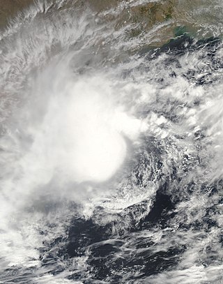
In May 2003, a tropical cyclone officially called Very Severe Cyclonic Storm BOB 01 produced the worst flooding in Sri Lanka in 56 years. The first storm of the 2003 North Indian Ocean cyclone season, it developed over the Bay of Bengal on May 10. Favorable environmental conditions allowed the system to intensify steadily while moving northwestward. The storm reached peak maximum sustained winds of 140 km/h (85 mph) on May 13, making it a very severe cyclonic storm according to the India Meteorological Department (IMD), which is the official Regional Specialized Meteorological Center for the basin. The cyclone drifted north over the central Bay of Bengal, gradually weakening due to heightened wind shear. Turning eastward, the storm deteriorated to a deep depression on May 16 before it curved northeastward and re-intensified into a cyclonic storm. It came ashore in western Myanmar and dissipated over land the following day.
Severe flooding in Myanmar began in July 2015 and continued into September, affecting 12 of the country's 14 states, resulting in about 103 deaths and affecting up to 1,000,000 people. Most of the casualties were reported from the Irrawaddy Delta. Torrential rains that began on 16 July destroyed farmland, roads, rail tracks, bridges and houses, leading the government to declare a state of emergency on 30 July in the four worst-hit regions in the west—Magway Division, Sagaing Division, Chin State and Rakhine State.

Hurricane Floyd in 1999 was the costliest natural disaster in New Jersey's history, until it was surpassed by Hurricane Irene in 2011. Damage in the state totaled $250 million (1999 USD), much of it in Somerset and Bergen counties. Seven people died in New Jersey during Floyd's passage – six due to drowning, and one in a traffic accident. A police lieutenant took his life after coordinating floodwater rescues for nearly 48 hours.
The 2017 Southern Thailand floods are the biggest floods in over 30 years in the southern part of the country during the regional annual monsoon season, which is distinct from other parts of the nation and mirrors that the Malay Peninsula. Between December 2016 and January 2017, Southern Thailand experienced a devastating flood disaster. The bulk of the 15 provinces in Southern Thailand were affected, and this flood event stood out from earlier flood catastrophes due to the massive, long-term damage it produced. Since around December 31, 2016, there have been abnormally significant rains for that time of year. According to the Meteorological Department, thunderstorms and strong winds continued to affect the southern regions. The amount of water in the Nan River, which flows through the Taphan Hin and Bang Mun Nak districts of the capital city of Phichit Province, rose at an alarming rate. This is the second deadly flood in a month in southern Thailand. The Department of Disaster Prevention and Mitigation (DDPM) of the Ministry of Interior estimates that there were 95 fatalities and 1,815,618 total victims in the 13 prefectures that were affected by the disaster. 4,314 road segments, 348 bridges, 126 weirs, and 2 sluices were among the destroyed infrastructure items. The extensive area of heavy rain and the simultaneous occurrence of numerous dam breaks severely damaged the local logistics infrastructure. While gum and palm oil help some regions' economies, others, like the extremely underdeveloped territory bordering Malaysia, are socioeconomically unstable. In these situations, the government made efforts in disaster restoration works by utilizing the military in a way that had never before been done for this purpose. Some 120 billion baht in damages are foreseen as of mid-January, much of this due to lost production in agriculture tourism and infrastructure. Rubber supply is particularly impacted. Particularly hard hit are palm and rubber plantations.

Kwasi Amoako-Attah is a Ghanaian lawyer, management consultant and politician. He is the Member of Parliament of the Atiwa West constituency in the Eastern Region of Ghana. He is a member of the New Patriotic Party and, as of 2017. He is a former Ghana's Minister for Roads and Highways.

The 2017 Benue State flooding took place in September 2017 in Benue State, Nigeria. It displaced at least 100,000 people, and damaged more than 2,000 homes.
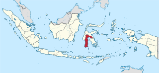
On 22 January 2019, floods caused by heavy rainfall struck the Indonesian province of South Sulawesi. At least 68 people were killed and thousands were displaced. Gowa Regency was particularly hard-hit, experiencing the majority of the fatalities.
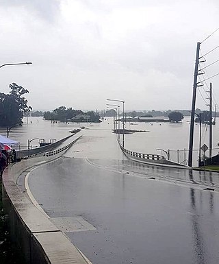
Extreme rainfall on the east coast of Australia beginning on 18 March 2021 led to widespread flooding in New South Wales, affecting regions from the North Coast to the Sydney metropolitan area in the south. Suburbs of Sydney experienced the worst flooding in 60 years, and the events were described by NSW Premier Gladys Berejiklian as "one in 100-year" flooding. Far-southeast communities in Queensland were also affected by flooding and heavy rainfall, though to a lesser extent than those in New South Wales.
Asamang Tamfoe is a mining and farming community near Anyinam in the Atewa East District in the Eastern Region of Ghana. The community is located in the Akyem Abuakwa Traditional Area. The Chief of Asamang Tamfoe is Osaberima Kwame Kuoh II. The Birim River and the Kobeng River runs through the community.
Floods in Ghana refer to a series of flood incidents that have caused property damage and loss of life. Floods are caused by excessive rainfall and dam spillages.

In 2024, heavy rainfall impacted several nations across West Africa, including Niger and Ghana. The rainy season in West Africa lasts from June to September, with June alone producing prolonged deadly and damaging floods.
Ghana is prone to a range of natural disasters, including floods, droughts, landslides, fires, and, on rare occasions, earthquakes. Among these, floods are the most common, often leading to outbreaks of waterborne diseases such as cholera, typhoid, and malaria. Historically, disaster management in Ghana has been largely reactive, focusing on response and relief efforts. However, in recent years, there has been a shift towards prevention and mitigation, with efforts to integrate disaster risk reduction and climate change adaptation into development planning.
The Agona Swedru flood occurred in June 2010 following heavy rains that caused the Birim River to overflow, leading to widespread destruction in the Agona West District of Ghana's Central Region.
References
- ↑ Amoako, Henry Kwadwo (2020-06-10). "A History of Dangerous Floods in Ghana". African Research Consult. Retrieved 2024-09-11.
- ↑ "Ghana Review International - A Free News agency for Ghanaian News". www.ghanareview.com. Retrieved 2024-09-12.
- 1 2 3 Online, Peace FM. "Atiwa Flooded". Peacefmonline.com - Ghana news. Retrieved 2024-09-11.
- ↑ "Five reported dead in Eastern Region floods". www.justiceghana.com. Retrieved 2024-09-11.
- 1 2 3 4 "President Mills Tours Flood Areas In Eastern Region - Ghana | ReliefWeb". reliefweb.int. 2011-07-26. Retrieved 2024-09-11.