
The Don River is a watercourse in southern Ontario that empties into Lake Ontario, at Toronto Harbour. Its mouth was just east of the street grid of the town of York, Upper Canada, the municipality that evolved into Toronto, Ontario. The Don is one of the major watercourses draining Toronto that have headwaters in the Oak Ridges Moraine.

Harbourfront is a neighbourhood on the northern shore of Lake Ontario within downtown Toronto, Ontario, Canada. Part of the Toronto waterfront, Harbourfront extends from Bathurst Street in the west, along Queens Quay, with its ill-defined eastern boundary being either Yonge Street or York Street. Its northern boundary is the Gardiner Expressway. Much of the district was former water lots filled in during the early 1900s to create a larger harbour district. After shipping patterns changed and the use of the Toronto Harbour declined, the area was converted from industrial uses to a mixed-use district that is mostly residential and leisure.

The Toronto waterfront is the lakeshore of Lake Ontario in the city of Toronto, Ontario, Canada. It spans 46 kilometres between the mouth of Etobicoke Creek in the west and the Rouge River in the east.

Toronto Harbour or Toronto Bay is a natural bay on the north shore of Lake Ontario, in Toronto, Ontario, Canada. Today, the harbour is used primarily for recreational boating, including personal vessels and pleasure boats providing scenic or party cruises. Ferries travel from docks on the mainland to the Islands, and cargo ships deliver aggregates and raw sugar to industries located in the harbour. Historically, the harbour has been used for military vessels, passenger traffic and cargo traffic. Waterfront uses include residential, recreational, cultural, commercial and industrial sites.

The Toronto Port Authority (TPA), doing business as PortsToronto (PT), is a port authority that is responsible for the management of the Port of Toronto, including the International Marine Passenger Terminal, and Billy Bishop Toronto City Airport. It was established under the Canada Marine Act as a government business enterprise that is self-funded, with directors appointed by three levels of government – the Government of Canada, the Government of Ontario and the City of Toronto. The TPA rebranded itself as PortsToronto in 2015.
Front Street is an east–west road in downtown Toronto, Ontario, Canada. First laid out in 1796, the street is one of the original streets of the Town of York. The street was laid out along the shoreline of Lake Ontario as it existed during that time. It remains an important street, with many important uses located along it, including the St. Lawrence Market, Meridian Hall, Union Station and the Metro Toronto Convention Centre. The eastern section of Front Street, in the West Don Lands, east of Cherry Street, is being rebuilt as a broad tree-lined boulevard, intended to be the pedestrian-friendly commercial spine of the new neighbourhood.

Sunnyside is a lakefront district in Toronto, Ontario, Canada. It includes a beach and park area along Lake Ontario's Humber Bay, from west of Exhibition Place to the mouth of the Humber River. The area has several recreation uses, including rowing clubs, sports clubs, picnic areas, playgrounds, a nightclub, a bathing pavilion and public pool. The area is a 3 kilometres (1.9 mi) long strip along the lakeshore, bounded by the Gardiner Expressway and rail lines, which separate it from the Parkdale, Roncesvalles and Swansea neighbourhoods to the north. The name originates in a local farm owned by John Howard, which was situated just to the north, on the location of the current St. Joseph's Health Centre hospital.
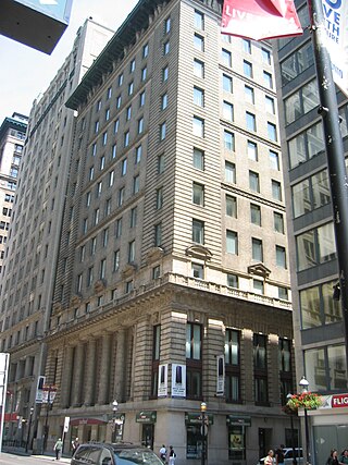
Trader's Bank Building is a 15-storey, 55.39 m (181.7 ft) early skyscraper, completed in 1906 at 67 Yonge Street in Toronto, Ontario, Canada. The building was designed by Carrère and Hastings, with construction beginning in 1905. It was the tallest building in the British Commonwealth until the Royal Liver Building was completed in 1911. It remains one of Canada's few surviving skyscrapers of the early 20th Century.

The Port of San Francisco is a semi-independent organization that oversees the port facilities at San Francisco, California, United States. It is run by a five-member commission, appointed by the Mayor subject to confirmation by a majority of the Board of Supervisors. The Port is responsible for managing the larger waterfront area that extends from the anchorage of the Golden Gate Bridge, along the Marina district, all the way around the north and east shores of the city of San Francisco including Fisherman's Wharf and the Embarcadero, and southward to the city line just beyond Candlestick Point. In 1968, the State of California, via the California State Lands Commission for the State-operated San Francisco Port Authority, transferred its responsibilities for the Harbor of San Francisco waterfront to the City and County of San Francisco / San Francisco Harbor Commission through the Burton Act AB2649. All eligible State port authority employees had the option to become employees of the City and County of San Francisco to maintain consistent operation of the Port of San Francisco.

The Port Lands of Toronto, Ontario, Canada are an industrial and recreational neighbourhood located about 5 kilometres south-east of downtown, located on the former Don River delta and most of Ashbridge's Bay.

The West Don Lands are the site of a neighbourhood under construction in Toronto, Ontario, Canada. The area is bordered by the Don River, King Street, Parliament Street and the rail line adjacent to the Gardiner Expressway. It is 80 hectares in size. A former industrial area, the area is being rebuilt as a mixed-use neighbourhood.

The Toronto Harbour Commission (THC) was a joint federal-municipal government agency based in Toronto, Ontario, Canada. The agency managed Toronto Harbour as well as being responsible for major works along the Toronto waterfront. It built both Malton Airport and the Toronto Island Airport in 1939. The agency was founded in 1911 and operated until 1999 when the port operations were transferred to the new Toronto Port Authority (TPA), now PortsToronto.

Jarvis Street is a north-south thoroughfare in downtown Toronto, Ontario, Canada, passing through some of the oldest developed areas in the city. Its alignment extends from Queens Quay East in the south to Bloor Street in the north. The segment south of Front Street is known as "Lower Jarvis Street" while the segment from Bloor Street to Mount Pleasant Road is known as "Ted Rogers Way".
Maple Leaf Mills Silos was one of two silo or grain elevator complexes that were built in the area between Spadina Quay and Maple Leaf Quay, on Toronto Harbour, in Toronto, Ontario, Canada. It was one of three "monumental" silo complexes that dominated the city's waterfront.
St. Andrew's Playground is a small park in downtown Toronto. It is located at the 450 Adelaide Street West, at the northwest corner of Brant St and Adelaide. It has a playground for children and an off-leash area for dogs that is surrounded by a short fence, with an accessible water fountain for pets, children, and adults. A Heritage Toronto plaque in the northwest corner describing the history and significance of the park was installed in 2007.

Corus Quay, originally named First Waterfront Place, is an eight-storey commercial office tower located on a 2.5-acre (1.0 ha) waterfront site in Toronto, Ontario, Canada. The CA$160 million building is the first major development planned for the East Bayfront district, and completed construction at the foot of Jarvis Street or Jarvis Street Slip. Corus Quay is Corus Entertainment's new Toronto headquarters, consolidating its 10 locations and 1,200 employees into one site. The building was designed by Diamond Schmitt Architects with interiors completed by Quadrangle Architects. The building was being developed by the Toronto Economic Development Corporation (TEDCO), a city agency. Funding for the project came from TEDCO's equity, city loans and a CA$12.5 million contribution from the city contributed via Waterfront Toronto.
East Bayfront LRT, also known as the Waterfront East LRT, is a planned Toronto streetcar line that would serve the East Bayfront and Port Lands areas in Toronto, Ontario, Canada. It would run from Union station under Bay Street and along Queens Quay and Cherry Street to a new loop along Commissioners Street east of Cherry Street on Ookwemin Minising. It would complement the existing 509 Harbourfront service that connects Union Station to Queens Quay west of Bay Street. Longer-term plans are to extend the East Bayfront line from Cherry and Commissioners Streets to the planned East Harbour Transit Hub along GO Transit's Lakeshore East line and the planned Ontario Line.

The Jack Layton Ferry Terminal is the ferry slip for Toronto Island ferries operated by the City of Toronto Parks, Forestry and Recreation Division. Three ferry routes provide transportation between mainland Toronto and Centre Island, Hanlan's Point and Ward's Island in the Toronto Islands, with levels of service to each destination differing depending on time of year. The terminal is located in the Toronto Harbour, behind the Westin Harbour Castle Hotel and adjacent to Harbour Square Park. It is south of Bay Street and Queens Quay in Toronto, Ontario, Canada.
Draper Street is a street in downtown Toronto, Ontario, Canada. It is a north-south street located to the west of Spadina Avenue, from Front Street West north to Wellington Street. Draper Street is notable for its collection of 28 nineteenth-century row cottages of the Second Empire style. They were designated by the City of Toronto government in the 1990s to have heritage status. The entire street is designated as a Heritage Conservation District as a way to preserve its heritage for posterity.
Ookwemin Minising meaning “place of black cherry trees” is a 39.6 hectares area in Toronto's Port Lands that has been converted to an island as part of Port Lands Flood Protection Project by Waterfront Toronto.
