3D World Atlas

Last updated

3D World Atlas
Developer(s) Cosmi Corporation
Stable release
2.1
Operating system Microsoft Windows
Type Virtual globe

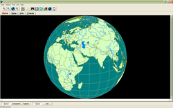
3D World Atlas is a virtual globe program developed by the Cosmi Corporation.

Contents

History

3D World Atlas was created by the Cosmi Corporation in 1999. It was programmed by Ron Paludan and the research was done by Eve Paludan. Information came from the 1999 World Factbook by the Central Intelligence Agency and the US Arms Control and Disarmament Agency. [1]

Features

As an atlas software, the 3D World Atlas has many features. These include, but are not limited to, world maps on a 3D globe, thousands of tables and charts, national flags, and a world clock. [2] The software also includes distance measuring and in-depth information on every country, including independence days, government types, and such. [2] There are many tools you can use on the program. These all perform basic tasks helping the viewer in understanding the world. [2] A zoom feature allows you to zoom into countries, and lists major cities, a print option allows you to print the current display of a page, and a find button allows you to find any city, country, river, lake, or continent within seconds. [2]

Other features include the ability to copy the current view onto the clipboard, where it can by displayed by pasting it on an image program such as Microsoft Paint, thematic maps, charts, and clocks that all allow you to customize the area, an "Earth shadow" feature which creates a shadow on the Earth if you are on 3D, and a 2D feature that allows you to see the Earth from a map perspective. The program also allows you to retrieve the coordinates of any point on Earth by hovering your mouse over the location you wish to know. [2]

Awards

3D World Atlas won the "editor's pick" from online software reviewer Software Informer. [3]

Related Research Articles

<span class="mw-page-title-main">Map</span> Symbolic depiction of relationships

A map is a symbolic depiction emphasizing relationships between elements of some space, such as objects, regions, or themes.

<span class="mw-page-title-main">Vector graphics</span> Computer graphics images defined by points, lines and curves

Vector graphics are a form of computer graphics in which visual images are created directly from geometric shapes defined on a Cartesian plane, such as points, lines, curves and polygons. The associated mechanisms may include vector display and printing hardware, vector data models and file formats, as well as the software based on these data models. Vector graphics is an alternative to raster or bitmap graphics, with each having advantages and disadvantages in specific situations.

<span class="mw-page-title-main">Atlas</span> Collection of maps

An atlas is a collection of maps; it is typically a bundle of maps of Earth or of a continent or region of Earth.

<span class="mw-page-title-main">Borland Sidekick</span>

Borland Sidekick was a personal information manager (PIM) launched by American software company Borland in 1984 under Philippe Kahn's leadership. It was an early and popular terminate-and-stay-resident program (TSR) for MS-DOS which enabled computer users to activate the program using a hot key combination while working in other programs. Although a text-mode program, Sidekick's window-based interface echoed that of the Apple Macintosh and anticipated the eventual look of Microsoft Windows 2.0. It included a personal calendar, text editor, calculator, ASCII chart, address book, and phone dialer. According to the prospectus for Borland's initial public offering of stock to the public, Sidekick sold more than 1 million copies in its first three years.

<span class="mw-page-title-main">Celestia</span> Astronomy computer program

Celestia is a real-time 3D astronomy software program that was created in 2001 by Chris Laurel. The program allows users to virtually travel through the universe and explore celestial objects that have been catalogued. Celestia also doubles as a planetarium, but the user is not restricted to the Earth's surface, like in other planetarium software such as Stellarium. Celestia can display objects of various scales using OpenGL.

<span class="mw-page-title-main">NASA WorldWind</span> Open-source virtual globe

NASA WorldWind is an open-source virtual globe. According to the website, "WorldWind is an open source virtual globe API. WorldWind allows developers to quickly and easily create interactive visualizations of 3D globe, map and geographical information. Organizations around the world use WorldWind to monitor weather patterns, visualize cities and terrain, track vehicle movement, analyze geospatial data and educate humanity about the Earth." It was first developed by NASA in 2003 for use on personal computers and then further developed in concert with the open source community since 2004. As of 2017, a web-based version of WorldWind is available online. An Android version is also available.

<span class="mw-page-title-main">DeLorme</span> Personal satellite tracking and navigation technology company

DeLorme Publishing Company is a producer of personal satellite tracking, messaging, and navigation technology. The company's main product, inReach, integrates GPS and satellite technologies. inReach provides the ability to send and receive text messages to and from anywhere in the world by using the Iridium satellite constellation. By pairing with a smartphone, navigation is possible with access to free downloadable topographic maps and National Oceanic and Atmospheric Administration (NOAA) charts. On February 11, 2016, the company announced that it had been purchased by Garmin, another multinational producer of GPS products and services.

<span class="mw-page-title-main">Google Earth</span> 3D Internet global map program

Google Earth is a computer program that renders a 3D representation of Earth based primarily on satellite imagery. The program maps the Earth by superimposing satellite images, aerial photography, and GIS data onto a 3D globe, allowing users to see cities and landscapes from various angles. Users can explore the globe by entering addresses and coordinates, or by using a keyboard or mouse. The program can also be downloaded on a smartphone or tablet, using a touch screen or stylus to navigate. Users may use the program to add their own data using Keyhole Markup Language and upload them through various sources, such as forums or blogs. Google Earth is able to show various kinds of images overlaid on the surface of the Earth and is also a Web Map Service client. In 2019, Google revealed that Google Earth now covers more than 97 percent of the world, and has captured 10 million miles of Street View imagery.

<span class="mw-page-title-main">Virtual globe</span> 3D software model or representation of Earth or another world

A virtual globe is a three-dimensional (3D) software model or representation of Earth or another world. A virtual globe provides the user with the ability to freely move around in the virtual environment by changing the viewing angle and position. Compared to a conventional globe, virtual globes have the additional capability of representing many different views of the surface of Earth. These views may be of geographical features, man-made features such as roads and buildings, or abstract representations of demographic quantities such as population.

<span class="mw-page-title-main">ArcGIS</span> Geographic information system maintained by Esri

ArcGIS is a family of client, server and online geographic information system (GIS) software developed and maintained by Esri.

<span class="mw-page-title-main">Mini-map</span> Miniature version of a map

A mini-map or minimap is a miniature map HUD element that is often placed at a screen corner in video games to help players in orienting themselves within the game world. They are often only a small portion of the screen and must be selective in what details they display. Elements included on mini-maps vary by video game genre. However, most minimaps feature at least one or more of the following: the position of the player character, allied units, structures, enemies, objectives, and surrounding terrain.

<span class="mw-page-title-main">Bing Maps</span> Web mapping service from Microsoft

Bing Maps is a web mapping service provided as a part of Microsoft's Bing suite of search engines and powered by the Bing Maps Platform framework which also support Bing Maps for Enterprise APIs and Azure Maps APIs. Since 2020, the map data is provided by TomTom, OpenStreetMap and others.

A compositing manager, or compositor, is software that provides applications with an off-screen buffer for each window. The compositing manager composites the window buffers into an image representing the screen and writes the result into the display memory. A compositing window manager is a window manager that is also a compositing manager.

<span class="mw-page-title-main">Web mapping</span> Process of using the maps delivered by geographic information systems (GIS) in World Wide Web

Web mapping or an online mapping is the process of using, creating, and distributing maps on the World Wide Web, usually through the use of Web geographic information systems. A web map or an online map is both served and consumed, thus, web mapping is more than just web cartography, it is a service where consumers may choose what the map will show.

ArcMap is the former main component of Esri's ArcGIS suite of geospatial processing programs. Used primarily to view, edit, create, and analyze geospatial data. ArcMap allows the user to explore data within a data set, symbolize features accordingly, and create maps. This is done through two distinct sections of the program, the table of contents and the data frame. In October 2020, it was announced that there are no plans to release 10.9 in 2021, and that ArcMap would no longer be supported after March 1, 2026. Esri is encouraging their users to transition to ArcGIS Pro.

<span class="mw-page-title-main">Marble (software)</span> Virtual globe 3-D modeling application

Marble is a virtual globe application which allows the user to choose among the Earth, the Moon, Venus, Mars and other planets to display as a 3-D model. It is free software under the terms of the GNU LGPL, developed by KDE for use on personal computers and smart phones. It is written in C++ and uses Qt.

<span class="mw-page-title-main">Life with PlayStation</span> Online multimedia application for the PlayStation 3

Life with PlayStation was an online multimedia application for the PlayStation 3 video game console on the PlayStation Network. The application had four channels, all of which revolved around a virtual globe that displayed information according to the channel. The application also included a client for Folding@home, a distributed computing project aimed at disease research. As of November 2012 the service has been discontinued.

<span class="mw-page-title-main">RemoteView</span> Geospatial software programs

RemoteView is the family name of a group of software programs designed by Textron Systems Geospatial Solutions to aid in analyzing satellite or aerial images of the Earth's surface for the purpose of collecting and disseminating geospatial intelligence. The National Geospatial-Intelligence Agency (NGA) was a user of RemoteView software.

<i>Encarta</i> Digital multimedia encyclopedia (1993-2009)

MicrosoftEncarta is a discontinued digital multimedia encyclopedia published by Microsoft from 1993 to 2009. Originally sold on CD-ROM or DVD, it was also available online via annual subscription, although later articles could also be viewed for free online with advertisements. By 2008, the complete English version, Encarta Premium, consisted of more than 62,000 articles, numerous photos and illustrations, music clips, videos, interactive content, timelines, maps, atlases and homework tools.

Cosmi Corporation (COSMI) is an American computer software company based in Carson, California.

References

  1. 3D World Atlas acknowledgement section
  2. 1 2 3 4 5 3D World Atlas
  3. "3D World Atlas Awards". Software Informer. Informer Technologies, Inc. Retrieved 30 December 2010.