
Waterfront is a major intermodal public transportation facility and the main transit terminus in Vancouver, British Columbia, Canada. It is located on West Cordova Street in Downtown Vancouver, between Granville and Seymour Street. The station is also accessible via two other street-level entrances, one on Howe Street to the west for direct access to the Expo Line and another on Granville Street to the south for direct access to the Canada Line.

King George is an elevated station on the Expo Line of Metro Vancouver's SkyTrain rapid transit system. The station is located in the south end of the Surrey City Centre district of Surrey, British Columbia, and is one of the outbound termini of the Expo Line, the other being Production Way–University station. The station is located at the corner of King George Boulevard and 100 Avenue, just north of Fraser Highway.

Metrotown is an elevated station on the Expo Line of Metro Vancouver's SkyTrain rapid transit system. The station is located in the Metrotown area of Burnaby, British Columbia, Canada. It is the fifth-busiest station in the SkyTrain system. The station is located between Central Boulevard and Beresford Street, east of Willingdon Avenue.
Nanaimo is a partially elevated station on the Expo Line of Metro Vancouver's SkyTrain rapid transit system. The station is located on Nanaimo Street between Vanness Avenue and East 24th Avenue in Vancouver, British Columbia. The station takes its name from Nanaimo Street, which is named after the city of Nanaimo on Vancouver Island. Situated on a hillcrest, the station provides riders with a view of the west side and Downtown Vancouver.

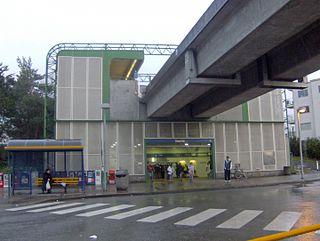
Joyce–Collingwood is an elevated station on the Expo Line, a part of Metro Vancouver's SkyTrain rapid transit system. The station is located on Joyce Street at Vanness Avenue, in the Renfrew–Collingwood neighbourhood of Vancouver, British Columbia, Canada.

Coast Mountain Bus Company (CMBC) is the contract operator for bus transit services in Metro Vancouver and is a wholly owned subsidiary of the South Coast British Columbia Transportation Authority, known locally as TransLink, the entity responsible for public transit in the region. The buses form part of the integrated transit network of the Lower Mainland.
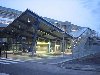
VCC–Clark is an elevated station on the Millennium Line of Metro Vancouver's SkyTrain rapid transit system. The station is named after the nearby Vancouver Community College (VCC) located in Vancouver, British Columbia, Canada and serves as the western terminus of the Millennium Line.

The 98 B-Line was a bus rapid transit line in Metro Vancouver, British Columbia, Canada. It connected Richmond, British Columbia to Downtown Vancouver, with a connection to Vancouver International Airport. It travelled mainly along Granville Street in Vancouver and dedicated bus lane on No. 3 Road in Richmond. It was operated by Coast Mountain Bus Company and was funded by TransLink. The route was 16 kilometres (9.9 mi) long. The line carried over 18,000 passengers daily. It was discontinued on September 7, 2009, two and a half weeks after the opening of the Canada Line, which replaced it.
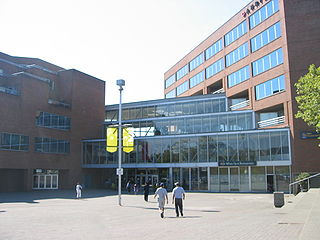
Oakridge Centre is a shopping centre in Vancouver, British Columbia, Canada. It is located at the intersection of West 41st Avenue and Cambie Street.
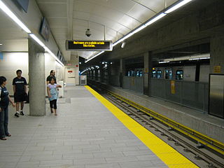
Langara–49th Avenue is an underground station on the Canada Line of Metro Vancouver's SkyTrain rapid transit system. It is located at the intersection of West 49th Avenue and Cambie Street in Vancouver, British Columbia, Canada.

Oakridge–41st Avenue is an underground station on the Canada Line of Metro Vancouver's SkyTrain rapid transit system. It is located at the intersection of West 41st Avenue and Cambie Street in Vancouver, British Columbia, Canada.

Broadway–City Hall is an underground station on the Canada Line of Metro Vancouver's SkyTrain rapid transit system. The station is located at the intersection of Cambie Street and West Broadway in Vancouver, British Columbia and is within walking distance of Vancouver City Hall, City Square Shopping Centre, Vancouver General Hospital and related facilities, as well as the surrounding Fairview and Mount Pleasant neighbourhoods.

Yaletown–Roundhouse is an underground station on the Canada Line of Metro Vancouver's SkyTrain rapid transit system. The station is located on Davie Street at Mainland Street, approximately 80 metres (260 ft) northwest of Pacific Boulevard, and serves the residential and retail areas of Yaletown and Downtown Vancouver in Vancouver, British Columbia.

Vancouver City Centre is an underground station on the Canada Line of Metro Vancouver's SkyTrain rapid transit system. The station is located on Granville Street, between West Georgia Street and Robson Street in Downtown Vancouver, and serves the shopping and entertainment districts along Granville and Robson streets, and the office and shopping complexes of Pacific Centre and Vancouver Centre.

Oakridge is a neighbourhood in the City of Vancouver with a multicultural residential and commercial area. It had a population of 11,795 in 2001, of which approximately 50 percent have Chinese as their mother tongue.

Dunbar Loop is one of the major transit exchanges in the western side of Vancouver. Opened on May 22, 1950, it is part of the TransLink system and is the westernmost exchange in the city of Vancouver..
The 91 B-Line is a future express bus line with bus rapid transit elements in Metro Vancouver, Canada that was outlined in the 2005 Vancouver/UBC Transit Plan for implementation in December 2009. It will replace the 43 Express that travels along 41st Avenue, a major east–west route which connects the University of British Columbia (UBC) to Joyce–Collingwood station on the SkyTrain system. The service will also connect with the Canada Line at Oakridge–41st Avenue station.

Commercial–Broadway is a rapid transit station complex in Metro Vancouver's SkyTrain system, serving an elevated portion of the Expo Line and a below-grade portion of the Millennium Line. It is a major transit hub, with the most boardings of any SkyTrain station, and a terminus of the region's busiest bus route, the 99 B-Line.
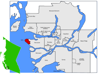
The University Endowment Lands (UEL) is an unincorporated area that lies to the west of the city of Vancouver, British Columbia, Canada, and adjacent to the University of British Columbia and the lands associated with that campus. Pacific Spirit Regional Park lies within the UEL. The UEL is part of Metro Vancouver. Mail sent to the UEL is addressed to "Vancouver" rather than the UEL.
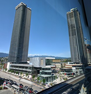
Brentwood Town Centre is a shopping mall in Burnaby, British Columbia, Canada. It is located in the Brentwood area of North Burnaby, at the intersection of Willingdon Avenue and Lougheed Highway, approximately 1.5 kilometres (0.93 mi) from the city of Vancouver.


