
The Independent Subway System, formerly known as the Independent City-Owned Subway System (ICOSS) or the Independent City-Owned Rapid Transit Railroad (ICORTR), was a rapid transit rail system in New York City that is now part of the New York City Subway. It was first constructed as the Eighth Avenue Line in Manhattan in 1932.

The Brooklyn Rapid Transit Company (BRT) was a public transit holding company formed in 1896 to acquire and consolidate railway lines in Brooklyn and Queens, New York City, United States. It was a prominent corporation and industry leader using the single-letter symbol B on the New York Stock Exchange.
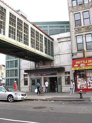
The Franklin Avenue station is a station complex shared by the BMT Franklin Avenue Line and the IND Fulton Street Line of the New York City Subway, located at Franklin Avenue and Fulton Street in Bedford–Stuyvesant, Brooklyn. It is served by the:
The BMT Jamaica Line, also known as the Broadway - Brooklyn Line is an elevated rapid transit line of the B Division of the New York City Subway, in Brooklyn and Queens, New York City, United States. It runs from the Williamsburg Bridge southeast over Broadway to East New York, Brooklyn, and then east over Fulton Street and Jamaica Avenue to Jamaica, Queens. In western Jamaica, the line goes into a tunnel, becoming the lower level of the Archer Avenue lines in central Jamaica. The J and Z trains serve the entire length of the Jamaica Line, and the M serves the line west of Myrtle Avenue.
The BMT Lexington Avenue Line was the first standard elevated railway in Brooklyn, New York, operated in its later days by the Brooklyn Rapid Transit Company, the Brooklyn–Manhattan Transit Corporation, and then the City of New York.
The Myrtle Avenue Line, also called the Myrtle Avenue Elevated, is a fully elevated line of the New York City Subway as part of the BMT division. The line is the last surviving remnant of one of the original Brooklyn elevated railroads. The remnant line operates as a spur branch from the Jamaica Line to Bushwick, Ridgewood, and Middle Village, terminating at its original eastern terminal across the street from Lutheran Cemetery. Until 1969, the line continued west into Downtown Brooklyn and, until 1944, over the Brooklyn Bridge to the Park Row Terminal in Manhattan.
The IND Culver Line is a rapid transit line of the B Division of the New York City Subway, extending from Downtown Brooklyn south to Coney Island, Brooklyn, New York City, United States. The local tracks of the Culver Line are served by the F service, as well as the G between Bergen Street and Church Avenue. The express tracks north of Church Avenue are used by the <F> train during rush hours in the peak direction. The peak-direction express track between Ditmas Avenue and Avenue X has not seen regular service since 1987.

The Park Row station was a major elevated railway terminal constructed on the Manhattan side of the Brooklyn Bridge, across from New York City Hall and the IRT's elevated City Hall station. It served as the terminal for BMT services operating over the Brooklyn Bridge Elevated Line from the BMT Fulton Street Line, BMT Myrtle Avenue Line, and their feeders. Until the opening of the nearby Williamsburg Bridge to elevated train traffic in 1913, it was the only Manhattan station available for elevated trains from Brooklyn and the only elevated station in Manhattan to be owned by a company other than the IRT or its predecessors.

The 34th Street–Herald Square station is an underground station complex on the BMT Broadway Line and the IND Sixth Avenue Line of the New York City Subway. It is located at Herald Square in Midtown Manhattan where 34th Street, Broadway and Sixth Avenue intersect, and is served by the D, F, N, and Q trains at all times; the R train at all times except late nights; the B, M, and W trains on weekdays; and the <F> train during rush hours in the peak direction.

The Fifth Avenue–59th Street station is a station on the BMT Broadway Line of the New York City Subway. Located under Grand Army Plaza near the intersection of 5th Avenue and 60th Street in Manhattan, it is served by the N train at all times, the W train on weekdays during the day, and the R train at all times except late nights.

The Grant Avenue station is a station on the IND Fulton Street Line of the New York City Subway. Located at Grant Avenue just north of Pitkin Avenue in City Line, Brooklyn, near the border between the boroughs of Brooklyn and Queens, it is served by the A train at all times. The station is the line's easternmost stop in Brooklyn; the Fulton Street Line continues east into Queens via the Fulton Street Elevated.

The Fifth Avenue Line, also called the Fifth Avenue Elevated or Fifth Avenue–Bay Ridge Line, was an elevated rail line in Brooklyn, New York City, United States. It ran above Hudson Avenue, Flatbush Avenue, Fifth Avenue, 38th Street, and Third Avenue from Downtown Brooklyn south to Bay Ridge. The portion on Third Avenue was called the Third Avenue Elevated to distinguish service from the elevated BMT West End Line; it was separate from the elevated IRT Third Avenue Line in Manhattan and the Bronx.

The Fulton Street Line, also called the Fulton Street Elevated or Kings County Line, was an elevated rail line mostly in Brooklyn, New York City, United States. It ran above Fulton Street from Fulton Ferry, Brooklyn, in Downtown Brooklyn east to East New York, and then south on Van Sinderen Avenue (southbound) and Snediker Avenue (northbound), east on Pitkin Avenue, north on Euclid Avenue, and east on Liberty Avenue to Ozone Park, Queens.

The Fulton Street station is a major New York City Subway station complex in Lower Manhattan. It consists of four linked stations on the IND Eighth Avenue Line, the IRT Lexington Avenue Line, the BMT Nassau Street Line and the IRT Broadway–Seventh Avenue Line. The complex is served by the 2, 4, A, and J trains at all times. The 3, 5, and C trains stop here at all times except late nights, and the Z stops during rush hours in the peak direction.
The Bridge-Jay Street station was a station on the demolished BMT Myrtle Avenue Line in Brooklyn, New York City. It had 2 tracks and 1 island platform. It was opened on April 10, 1888 as Jay Street, and served Myrtle Avenue Line trains as well as the BMT Lexington Avenue Line, and until it was demolished in 1940, the BMT Fifth Avenue Line, which itself also served BMT Culver Line trains. From 1944 until its demolition in 1969, it had a free transfer to the IND Fulton Street and IND Culver lines at Jay Street – Borough Hall. Around that time, it was renamed "Bridge-Jay Street." The next stop to the north was Navy Street for trains traveling on the Lexington & Myrtle Avenue Lines, and Fulton Street other trains until its demolition in 1940. The next stop to the south was Adams Street. The station was closed on October 4, 1969, after a fire on the elevated structure.
The Saint Marks Avenue station was a station on the demolished section of the BMT Fifth Avenue Line in Brooklyn, New York City. Served by trains of the BMT Culver Line and BMT Fifth Avenue Line, it had 2 tracks and 2 side platforms. The station was opened on June 22, 1889, at Fifth Avenue and St. Marks Place, which is renamed St. Marks Avenue east of Fifth Avenue. It also had a connection to the Bergen Street Line trolleys. It closed on May 31, 1940.
Nostrand Avenue was a station on the demolished BMT Fulton Street Line. It was originally built on April 24, 1888 and had 2 tracks and 2 side platforms. It was served by trains of the BMT Fulton Street Line, and served as the eastern terminus of the line for a month and a week. Nostrand Avenue station had connections to at least four streetcar lines; The Nostrand Avenue Trolley, the Lorimer Street Line, the Marcy Avenue Line, and the Ocean Avenue Line trolleys. Under the Dual Contracts, the station was the west end of a project to expand the line from two to three tacks. On April 9, 1936, the Independent Subway System built the Nostrand Avenue Subway Station along the IND Fulton Street Line. The el station became obsolete, and it closed on May 31, 1940.
The Ralph Avenue station was a station on the demolished BMT Fulton Street Line in Brooklyn, New York City. It had 2 tracks and 2 side platforms. It was opened on September 20, 1888, and served by trains of the BMT Fulton Street Line. It also had a connection to the trolley lines of the same name. Ralph Avenue was the easternmost station on the line until it was expanded to Rockaway Avenue on November 16, 1888. Less than a month later Saratoga Avenue would replace Ralph Avenue as the penultimate station on the line. The next stop to the east was Saratoga Avenue. The next stop to the west was Utica Avenue.
The Troy Avenue station was a station on the demolished BMT Fulton Street Line in Brooklyn, New York City. It had 2 tracks and 2 side platforms. It was opened sometime during the middle of 1888, and served by trains of the BMT Fulton Street Line. Sometime between 1912 and 1924, the nearby Albany–Sumner Avenues station was closed due to the Dual Contracts addition of a third track between Nostrand Avenue and Hinsdale Street. Commuters from that station were redirected here. It was served by BMT 13 trains throughout its existence.


