

84 Brook Green is a building at 84 Brook Green, Hammersmith, London, W6 7BD.
The house dates from the mid-19th century. It was both the workplace of the Silver Studio and the Silver family.
84 Brook Green is a building at 84 Brook Green, Hammersmith, London, W6 7BD.
The house dates from the mid-19th century. It was both the workplace of the Silver Studio and the Silver family.

The Jubilee line is a London Underground line that runs between Stratford in east London and Stanmore in the suburban north-west, via the Docklands, South Bank and West End. Opened in 1979, it is the newest line on the network, although some sections of track date back to 1932 and some stations to 1879.
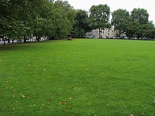
Eel Brook Common is common land in the London Borough of Hammersmith and Fulham, close to Fulham Broadway, with its south-eastern boundary along New King's Road. According to the Fulham Society, the name actually is a derivative of 'hill brook common' - which relates to Musgrave Crescent, which is raised much higher than the surrounding land. It is believed that this is artificial and it probably was originally a Bronze Age mound - either a raised piece of ground to defend against attackers, or as a burial mound. When you leave Eel Brook Common from the north side, you go up a steep ramp - up onto Musgrave Crescent. It is within the Hammersmith and Fulham Conservation Area of Parsons Green.
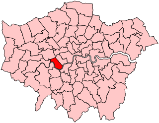
Hammersmith and Fulham was a constituency represented in the House of Commons of the Parliament of the United Kingdom. It elected one Member of Parliament (MP) by the first past the post system of election. The constituency was abolished at the 2010 general election with its wards being split between two new constituencies of Chelsea and Fulham & Hammersmith.
Cox Green School is a secondary school with academy status in Berkshire, England.
Pymmes Park is located in Edmonton, London and is bordered by the North Circular Road.

Salmons Brook is a minor tributary of the River Lea, located in the London Borough of Enfield.

The Pymmes Brook Trail is located in the London Boroughs of Barnet, Enfield and Haringey and is just under 13 miles (21 km) long. The brook is named after William Pymme, a local landowner.

Wayne Township is one of fifteen townships in Wayne County, Indiana, United States. As of the 2010 census, its population was 41,217 and it contained 19,510 housing units.

Webster Township is one of fifteen townships in Wayne County, Indiana, United States. As of the 2010 census, its population was 1,272 and it contained 552 housing units.

Capel Manor College is London’s only specialist environmental college, offering a diverse range of full and part-time courses in further and higher education for young people and adults. It is located in Enfield.
Burtonhole Lane and Pasture is a 6.5 hectare Site of Borough Importance for Nature Conservation, Grade II, between Mill Hill and Totteridge in the London Borough of Barnet. It consists of Burtonhole Lane between Partingdale Lane and Burtonhole Close, a footpath east from Burtonhole Lane towards Folly Brook, two fields south of the footpath, and a narrow belt of privately owned woodland north of the footpath. Burtonhole Brook, a tributary of Folly Brook, crosses Burtonhole Lane and the fields.

Burnt Oak Brook is a one-mile-long stream between Mill Hill and Burnt Oak in the London Borough of Barnet. It is a tributary of the Silk Stream, which is a tributary of the River Brent, which is a tributary of the River Thames.

The Northern line Embankment between Totteridge and Whetstone and High Barnet tube stations on the Northern line is a Site of Borough Importance for Nature Conservation, Grade II, in the London Borough of Barnet.

Turner's Wood is a 2.4 hectare Site of Borough Importance for Nature Conservation, Grade II, in Hampstead Garden Suburb in the London Borough of Barnet. It is designated as a private natural woodland and bird sanctuary.

Gutteridge Wood and Meadows is a Local Nature Reserve (LNR) in Yeading in the London Borough of Hillingdon, which is owned by Hillingdon Council and managed by the London Wildlife Trust (LWT). It is also part of the Yeading Brook Meadows Site of Metropolitan Importance for Nature Conservation, which includes two neighbouring reserves managed by the LWT, Ten Acre Wood and Yeading Brook Meadows LNRs.

The Queen's Head is a pub at 13 Brook Green, Hammersmith, London W6.

Houghton Brook is a minor tributary of the River Lea. Houghton Brook starts in Houghton Regis and is fed by a number of smaller brooks in the area, mostly supplied by surface water from farmland and the various local villages and housing estates.

The Green Man is a disused public house in High Street, Potters Bar, England, and a grade II listed building with Historic England. It was built in the mid 17th century, and subsequently remodelled and extended.

The principal war memorial in Enfield Town is the cenotaph that stands in Chase Green Gardens and is a grade II listed monument with Historic England. It commemorates men lost in both the World Wars as does a plaque in the town's main post office. In addition, in 2003 a memorial to those lost in the Arctic campaign of the Second World War was unveiled.
Milford Green and Coxhill Green is a 15-hectare (37-acre) nature reserve north-east of Chobham in Surrey. It is owned by Surrey County Council and managed by the Surrey Wildlife Trust.
| Wikimedia Commons has media related to 84 Brook Green . |
Coordinates: 51°29′48″N0°13′14″W / 51.496690°N 0.22053123°W
| | This article about a London building or structure is a stub. You can help Wikipedia by expanding it. |