A highway is any public or private road or other public way on land. It is used for major roads, but also includes other public roads and public tracks. In the United States, it is used as an equivalent term to controlled-access highway, or a translation for Autobahn, autostrada, autoroute, etc.

The Regional Municipality of Durham, informally referred to as Durham Region, is a regional municipality in Southern Ontario, Canada. Located east of Toronto and the Regional Municipality of York, Durham forms the east-end of the Greater Toronto Area and part of the Golden Horseshoe region. It has an area of approximately 2,500 km2 (970 sq mi). The regional government is headquartered in Whitby.

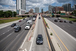
The Greater Toronto Area, commonly referred to as the GTA, includes the City of Toronto and the regional municipalities of Durham, Halton, Peel, and York. In total, the region contains 25 urban, suburban, and rural municipalities. The Greater Toronto Area begins in Burlington in Halton Region to the west, and extends along Lake Ontario past downtown Toronto eastward to Clarington in Durham Region.

Southern Ontario is a primary region of the Canadian province of Ontario. It is the most densely populated and southernmost region in Canada, with approximately 13.5 million people, approximately 36% of Canada's population of 37 million. The region lies south of the province's other primary region, Northern Ontario, although the exact northern boundary of Southern Ontario is disputed. However, its core region is situated south of Algonquin Park, the latter being in an area of transition between coniferous forest north of the French and Mattawa Rivers and southern deciduous forest. It covers between 14 and 15% of the province, depending on the inclusion of the Parry Sound and Muskoka districts which also lie in the transitional area between northern and southern forest regions. Southern Ontario differs greatly from Northern Ontario, having a much higher population density, a different climate, and a different culture than its northern counterpart. It is broken into smaller subregions, including Central Ontario, Eastern Ontario, the Golden Horseshoe, and Southwestern Ontario.

5-1-1 is a transportation and traffic information telephone hotline in some regions of the United States and Canada. Travelers can dial 511, a three-digit telephone number, on landlines and most mobile phones. The number has also extended to be the default name of many state and provincial transportation department road conditions Web sites, such as Wisconsin's site. It is an example of an N11 code, part of the North American Numbering Plan.
Area codes 905, 289, 365, and 742 are telephone area codes in the North American Numbering Plan (NANP) for the Golden Horseshoe region that surrounds Lake Ontario in Southern Ontario, Canada. The numbering plan area (NPA) comprises (clockwise) the Niagara Peninsula, the city of Hamilton, the regional municipalities of Halton, Peel, York, Durham, and parts of Northumberland County, but excludes the City of Toronto.

Area codes 416, 647, and 437 are telephone area codes in the North American Numbering Plan (NANP) for the city of Toronto, Ontario, Canada. Area code 416 is one of the original North American area codes created by the American Telephone and Telegraph Company (AT&T) in 1947. Area codes 647 and 437 are additional area codes for the same numbering plan area (NPA), forming an overlay numbering plan.
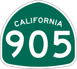
State Route 905 (SR 905), also known as the Otay Mesa Freeway, is an 8.964-mile-long (14.426 km) state highway in San Diego, in the southwestern part of the U.S. state of California. It connects I-5 and I-805 in San Ysidro to the Mexican border at Otay Mesa. The entire highway from I-5 to the international border is a freeway with a few exits that continues east from the I-805 interchange before turning southeast and reaching the border.

A county highway is a road in the United States and in the Canadian province of Ontario that is designated and/or maintained by the county highway department. Route numbering can be determined by each county alone, by mutual agreement among counties, or by a statewide pattern.

Bronte is the community that makes up much of the west end of Oakville, in Ontario, Canada. Twelve Mile Creek flows through the middle of town and empties into Lake Ontario. Main roads include Bronte Road (north-south), Lakeshore Road West and Rebecca Street (east-west). Streets in the business section include Lakeshore, Jones, Marine, and Ontario Street. Bronte is also accessed via a superhighway located to the north of the former village. Other main roads include Third Line, Speers Road and Burloak Drive to the west

State Route 11 (SR 11) is a state highway in the U.S. state of California. The first phase of the highway opened in 2016, connecting SR 125 and SR 905 with Enrico Fermi Drive in the Otay Mesa area of San Diego. It is planned to be extended from Enrico Fermi Drive to the proposed U.S.–Mexico border crossing at Otay Mesa East. There are also plans for an interchange at Siempre Viva Road and to convert the highway to a toll road once the entire route is completed. Planning for the road began in the 1990s, and construction started in 2013.

Udora is a small rural community in Ontario, Canada. It has a population estimated to be around 500 and is situated in the most south-eastern part of Georgina, split between York Region and Durham Region. The town was originally known as Snoddon Corners and was the location of the Snoddon Hotel.
Sunderland is a community located approximately 100 km northeast of Toronto, Ontario in Brock Township, in the Regional Municipality of Durham, Ontario, Canada. This is currently one of the very few populated areas of the Greater Toronto Area where the Trans Canada Highway passes near, thus also making this the closest point from the highway to the City of Toronto at 100 kilometres (62 mi) apart.
Copetown is a rural neighbourhood of the city of Hamilton, Ontario, Canada, located northeast of Brantford. William Cope, a United Empire Loyalist from the U.S. state of New York settled here in 1794. The community was renamed after his son Conradt in 1851. The current population of this community is approximately 130 residents.

Highland Creek is a neighbourhood in eastern Toronto, Ontario, Canada. It is located along the southern portion of the river of the same name in the former suburb of Scarborough. To the east are the neighbourhoods of Port Union and West Rouge, to the west West Hill and Woburn, and to the south Centennial Scarborough.