
The A12 is a major road in Eastern England. It runs north-east/south-west between London and the coastal town of Lowestoft in the north-eastern corner of Suffolk, following a similar route to the Great Eastern Main Line until Ipswich. A section of the road between Lowestoft and Great Yarmouth became part of the A47 in 2017. Between the junctions with the M25 and the A14, the A12 forms part of the unsigned Euroroute E30. Unlike most A roads, this section of the A12, together with the A14 and the A55, has junction numbers as if it were a motorway.

The A47 is a major trunk road in England linking Birmingham to Lowestoft, Suffolk, maintained and operated by National Highways. Most of the section between Birmingham and Nuneaton is now classified as the B4114. From Peterborough eastwards, it is a trunk road.

Leicester Forest East (LFE) is a large suburban village in Leicestershire, England, west of Leicester, straddling the M1 motorway. It is part of the Blaby district.
Tyburn is a ward in Birmingham, in the county of West Midlands, England formerly known as Kingsbury.

The A16 road is a principal road of Lincolnshire in the East Midlands region of England, connecting the port of Grimsby and Peterborough, where it meets the A1175, A47 & A1139 then on to the A1 and the A605; the latter, in turn, giving a through route to Northampton and the west, and south west of England. Its length is 78 miles (126 km). The road was "de-trunked", with responsibility largely returned to Lincolnshire County Council from the Highways Agency in 2002.
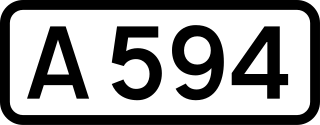
The A594 Central Ring is Leicester's central distributor road network.

The A563 is the designation for the ring road of Leicester, England. It forms a near-complete circuit except for a gap of around 2.2 miles (3.5 km) in the east of the city. An indirect route linking the gap involves the (A47) A6030, and A6. The A563 was formerly referred to as the Outer Ring.

The A6030 is a small ring-road entirely within the built-up central area of Leicester, from its roundabout with the A563 near Hamilton, south to cross the A47 at Evington, past Leicester General Hospital and the Leicestershire Golf Club to meet the A6 again at Stoneygate near Oadby.

The A146 is an A road that connects Norwich in Norfolk and Lowestoft in Suffolk, two of East Anglia's largest population centres. It is around 27 miles (43 km) in length and has primary classification along its entire route. It is mainly single carriageway throughout its route, with the exception of a section of dual carriageway on the southern edge of Norwich.

An unused highway is a highway or highway ramp that was partially or fully constructed, but went unused or was later closed or part of a future expansion. An unused roadway or ramp may often be referred to as an abandoned road, ghost road, highway to nowhere, stub ramp, ghost ramp, ski jump, stub street, stub-out, or simply stub.

The A47 autoroute is a 29.5-kilometre-long (18.3 mi) highway in central France. Completed in 1983 it connects Givors (Lyon) to Saint-Étienne. It also serves the suburbs south-west of Lyon and east of Saint-Étienne.
Necton is a village situated on a turning off the A47 main road between Swaffham and East Dereham in the Breckland district of mid-Norfolk. As at the 2001 census it had a population of 1,865 residents and an area of 15.48 km2 (5.98 sq mi), increasing to a population of 1,923 at the 2011 census. It has a number of facilities including a primary school, playing field, social club, pub, post office a shop, a butcher's and a Asda Express fuel station at the top of the village along the A47.
Gorleston North railway station was a former station on the Norfolk and Suffolk Joint Railway connecting Great Yarmouth with Lowestoft. It was located on the northern outskirts of Gorleston-on-Sea, close to Great Yarmouth. Gorleston North was closed during the Second World War following bomb damage. Trains continued to pass through the station until services were withdrawn from the line in 1970. The station was demolished after closure and the site is now occupied by the A47 road.

The City of Peterborough in East Anglia has an extensive and well integrated road network, owing partly to its status as a new town. Since the 1960s, the city has seen considerable expansion and its various suburbs are linked by a system of parkways.

Wansford Road railway station was located in Northamptonshire serving the village of Wansford. It was some distance east of the village on the A47 road, although still nearer than the more important Wansford station of the London & North Western Railway. The station was built in 1867.
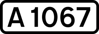
The A1067 is an English A road entirely in the county of Norfolk. It runs from Fakenham Northern By-Pass (A148) to Norwich inner ring road (A147).

The A46 is a road in County Fermanagh, in Northern Ireland. It forms part of the route from Dublin to Ballyshannon. It stretches 23.6 miles from Enniskillen to Belleek along the southwestern shoreline of Lower Lough Erne.
The A47 road runs from Kesh to Belleek along the north shore of Lower Lough Erne. The A47 commences from Letterkeen, a townland north of Kesh in County Fermanagh, and heads due west near the shores of Lower Lough Erne and over the eastern causeway and bridge onto Boa Island.