
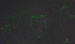
A constellation is an area on the celestial sphere in which a group of visible stars forms a perceived pattern or outline, typically representing an animal, mythological subject, or inanimate object.

A Flamsteed designation is a combination of a number and constellation name that uniquely identifies most naked eye stars in the modern constellations visible from southern England. They are named for John Flamsteed who first used them while compiling his Historia Coelestis Britannica.

Hydrus is a small constellation in the deep southern sky. It was one of twelve constellations created by Petrus Plancius from the observations of Pieter Dirkszoon Keyser and Frederick de Houtman and it first appeared on a 35-cm (14 in) diameter celestial globe published in late 1597 in Amsterdam by Plancius and Jodocus Hondius. The first depiction of this constellation in a celestial atlas was in Johann Bayer's Uranometria of 1603. The French explorer and astronomer Nicolas Louis de Lacaille charted the brighter stars and gave their Bayer designations in 1756. Its name means "male water snake", as opposed to Hydra, a much larger constellation that represents a female water snake. It remains below the horizon for most Northern Hemisphere observers.

Johann Elert Bode was a German astronomer known for his reformulation and popularisation of the Titius–Bode law. Bode determined the orbit of Uranus and suggested the planet's name.

Sextans is a faint, minor constellation on the celestial equator which was introduced in 1687 by Polish astronomer Johannes Hevelius. Its name is Latin for the astronomical sextant, an instrument that Hevelius made frequent use of in his observations.

Columba is a faint constellation designated in the late sixteenth century, remaining in official use, with its rigid limits set in the 20th century. Its name is Latin for dove. It takes up 1.31% of the southern celestial hemisphere and is just south of Canis Major and Lepus.

Indus is a constellation in the southern sky first professionally surveyed by Europeans in the 1590s and mapped on a globe by Petrus Plancius by early 1598. It was included on a plate illustrating southern constellations in Bayer's sky atlas Uranometria in 1603. It lies well south of the Tropic of Capricorn but its triangular shape can be seen for most of the year from the Equator. It is elongated from north to south and has a complex boundary. The English translation of its name is generally given as the Indian, though it is unclear which indigenous people the constellation was originally supposed to represent.

Uranometria is a star atlas produced by Johann Bayer. It was published in Augsburg in 1603 by Christoph Mang under the full title Uranometria: omnium asterismorum continens schemata, nova methodo delineata, aereis laminis expressa. The word "uranometria", from Ancient Greek οὐρανός (ouranós) 'sky, heavens' and μέτρον (metron) 'measure', literally translates to "measuring the heavens".

Noctua was a constellation near the tail of Hydra in the southern celestial hemisphere, but is no longer recognized. It was introduced by Alexander Jamieson in his 1822 work, A Celestial Atlas, and appeared in a derived collection of illustrated cards, Urania's Mirror. Now designated Asterism a, the owl was composed of the stars Sigma Librae, 4 Librae and 54–57 Hydrae, which range from 3rd to 6th magnitude.

Quadrans Muralis was a constellation created by the French astronomer Jérôme Lalande in 1795. It depicted a wall-mounted quadrant with which he and his nephew Michel Lefrançois de Lalande had charted the celestial sphere, and was named Le Mural in the French atlas. It was between the constellations of Boötes and Draco, near the tail of Ursa Major, containing stars between β Bootis (Nekkar) and η Ursae Majoris (Alkaid).
Telescopium Herschelii, also formerly known as Tubus Hershelli Major, is a former constellation in the northern celestial hemisphere. Maximilian Hell established it in 1789 to honour Sir William Herschel's discovery of the planet Uranus. It fell out of use by the end of the 19th century. θ Geminorum at apparent magnitude 4.8 was the constellation's brightest star.

Turdus Solitarius was a constellation created by French astronomer Pierre Charles Le Monnier in 1776 from stars of Hydra's tail. It was named after the Rodrigues solitaire, an extinct flightless bird that was endemic to the island of Rodrigues East of Madagascar in the Indian Ocean. It was replaced by another constellation, Noctua, in A Celestial Atlas (1822) by the British amateur astronomer Alexander Jamieson, but neither was adopted by the International Astronomical Union among its 88 recognized constellations.

Officina Typographica was a constellation located east of Sirius and Canis Major, north of Puppis, and south of Monoceros. It was drawn up by Johann Bode and Joseph Jérôme de Lalande in 1798, and included in the former's star atlas Uranographia in 1801, honouring the printing press of Johannes Gutenberg. Lalande reported wanting to honour French and German discoveries in the same manner that Nicolas-Louis de Lacaille had done for his new constellations. It was called Buchdrucker-Werkstatt by Bode initially, and later Atelier Typographique in the 1825 work Urania's Mirror, Atelier de l’Imprimeur by Preyssinger in 1862 and Antlia Typographiae in 1888.

A star chart is a celestial map of the night sky with astronomical objects laid out on a grid system. They are used to identify and locate constellations, stars, nebulae, galaxies, and planets. They have been used for human navigation since time immemorial. Note that a star chart differs from an astronomical catalog, which is a listing or tabulation of astronomical objects for a particular purpose. Tools using a star chart include the astrolabe and planisphere.

Celestial cartography, uranography, astrography or star cartography is the aspect of astronomy and branch of cartography concerned with mapping stars, galaxies, and other astronomical objects on the celestial sphere. Measuring the position and light of charted objects requires a variety of instruments and techniques. These techniques have developed from angle measurements with quadrants and the unaided eye, through sextants combined with lenses for light magnification, up to current methods which include computer-automated space telescopes. Uranographers have historically produced planetary position tables, star tables, and star maps for use by both amateur and professional astronomers. More recently, computerized star maps have been compiled, and automated positioning of telescopes uses databases of stars and of other astronomical objects.
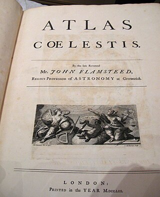
The Atlas Coelestis is a star atlas published posthumously in 1729, based on observations made by the First Astronomer Royal, John Flamsteed.
Alexander Jamieson (1782–1850) was a Scottish writer and schoolmaster, now best known as a rhetorician. He has been described as effectively a professional textbook writer. After the failure of his school, he worked as an actuary.
Urania's Mirror; or, a view of the Heavens is a set of 32 astronomical star chart cards, first published in November 1824. They are illustrations based on Alexander Jamieson's A Celestial Atlas, but the addition of holes punched in them allow them to be held up to a light to see a depiction of the constellation's stars. They were engraved by Sidney Hall, and were said to be designed by "a lady", but have since been identified as the work of the Reverend Richard Rouse Bloxam, an assistant master at Rugby School.

Norma Nilotica is an obsolete constellation, or asterism, no longer in use by astronomers. Its name means "The Nile's Ruler" in Latin. It was created by Alexander Jamieson and first appeared in his book A Celestial Atlas, published in 1822. It subsequently appeared in Urania's Mirror (1824) and Elijah Hinsdale Burritt's 1835 book Atlas Designed to Illustrate the Geography of the Heavens. The constellation is depicted as a measuring rod held in the left hand of the water carrier Aquarius. Depicting Aquarius with a nilometer references the ancient Egyptian association of Aquarius with the flooding of the Nile river.
