
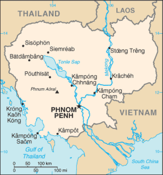
Laos, officially the Lao People's Democratic Republic (LPDR), is the only landlocked country in Southeast Asia. It is bordered by Myanmar and China to the northwest, Vietnam to the east, Cambodia to the southeast, and Thailand to the west and southwest. Its capital and most populous city is Vientiane.

The People's Army of Vietnam (PAVN), officially the Vietnam People's Army, also recognized as the Vietnamese Army, the People's Army or colloquially the Troops, is the national military force of the Socialist Republic of Vietnam and the armed wing of the ruling Communist Party of Vietnam (CPV). The PAVN is the backbone component of the Vietnam People's Armed Forces and includes: Ground Force, Navy, Air Force, Border Guard and Coast Guard. Vietnam does not have a separate and formally-structured Ground Force or Army service. Instead, all ground troops, army corps, military districts and special forces are designated under the umbrella term combined arms and are belonged to the Ministry of National Defence, directly under the command of the CPV Central Military Commission, the Minister of National Defence, and the General Staff of the Vietnam People's Army. The military flag of the PAVN is the National flag of the Socialist Republic of Vietnam defaced with the motto Quyết thắng added in yellow at the top left.

The Ho Chi Minh Trail, also called Annamite Range Trail was a logistical network of roads and trails that ran from North Vietnam to South Vietnam through the kingdoms of Laos and Cambodia. The system provided support, in the form of manpower and materiel, to the Viet Cong and the People's Army of Vietnam (PAVN), during the Vietnam War. Construction for the network began following the North Vietnamese invasion of Laos in July 1959. At the time it was believed to be the main supply route, however it later transpired that the Sihanouk Trail which ran through Cambodia was handling significantly more material.

Kaysone Phomvihane was the first leader of the Communist Lao People's Revolutionary Party from 1955 until his death in 1992. After the Communists seized power in the wake of the Laotian Civil War, he was the de facto leader of Laos from 1975 until his death. He served as the first Prime Minister of the Lao People's Democratic Republic from 1975 to 1991 and then as the second President from 1991 to 1992. His theories and policies are officially known as Kaysone Phomvihane Thought.

The Laotian Civil War was waged between the Communist Pathet Lao and the Royal Lao Government from 23 May 1959 to 2 December 1975. The Kingdom of Laos was a covert theater during the Vietnam War with both sides receiving heavy external support in a proxy war between the global Cold War superpowers. The fighting also involved the North Vietnamese, South Vietnamese, American and Thai armies, both directly and through irregular proxies. The war is known as the Secret War among the American CIA Special Activities Center, and Hmong and Mien veterans of the conflict.

The bamboo curtain was a political demarcation between the communist states of East Asia, particularly the People's Republic of China and the capitalist states of East, South and Southeast Asia. To the north and northwest lay the communist states of: China, Russia, North Vietnam, North Korea and the Mongolian People's Republic. To the south and east lay the capitalist countries of India, Pakistan, Japan, Indonesia, Malaysia, Singapore, the Philippines, Thailand, Taiwan, South Korea, Hong Kong and Macau.
Quảng Nam is a coastal province near northernmost part of the South Central Coast region, the Central of Vietnam. It borders Thừa Thiên Huế to the north, Đà Nẵng to the northeast, Kon Tum to the southwest, Quảng Ngãi to the southeast, Sekong of Laos to the west and the South China Sea to the east.
During the Cold War, the Indochina wars were a series of wars which were waged in Indochina from 1946 to 1991, by communist forces against the opponents. The term "Indochina" referred to former French Indochina, which included the current states of Vietnam, Laos, and Cambodia. In current usage, it applies largely to a geographic region, rather than to a political area. The wars included:

Army and warfare made their first appearance in Vietnamese history during the 3rd millennium BC. Throughout thousands of years, wars played a great role in shaping the identity and culture of people inhabited the land which is modern day Vietnam. Vietnam is considered one of the most peace-loving countries in Southeast Asia, and there is even greater belief that Vietnam can be the most peace-loving country in Southeast Asia and one of the most peaceful countries in Asia and the world.

Quảng Bình is a southern coastal province in the North Central Coast region, the Central of Vietnam. It borders Hà Tĩnh to the north, Quảng Trị to the south, Khammouane of Laos to the west and the Gulf of Tonkin to the east.

This article details the history of Laos from 1945 to the present.
The Sihanouk Trail was a logistical supply system in Cambodia used by the People's Army of Vietnam (PAVN) and its Viet Cong (VC) guerrillas during the Vietnam War (1960–1975). Between 1966 and 1970, this system operated in the same manner and served the same purposes as the much better known Ho Chi Minh trail which ran through the southeastern portion of the Kingdom of Laos. The name is of American derivation, since the North Vietnamese considered the system integral to the supply route mentioned above. U.S. attempts to interdict this system began in 1969.

Lao Bảo is a small town in Hướng Hóa District of Quảng Trị Province, Vietnam, located in the North Central Coast region, near the border with Laos. Its population is approximately 30,000.
North Vietnam supported the Pathet Lao to fight against the Kingdom of Laos between 1958 and 1959. Control over Laos allowed for the eventual construction of the Ho Chi Minh Trail that would serve as the main supply route for enhanced NLF and NVA activities in the Republic of Vietnam. As such, the support for Pathet Lao to fight against Kingdom of Laos by North Vietnam would prove decisive in the eventual communist victory over South Vietnam in 1975 as the South Vietnamese and American forces could have prevented any NVA and NLF deployment and resupply if these only happened over the 17th Parallel, also known as the Demilitarized Zone (DMZ), a narrow strip of land between North and South Vietnam that was closely guarded by both sides. It also helped the Pathet Lao win against the Kingdom of Laos, even though the Kingdom of Laos had American support.

National Route 9 runs across Vietnam roughly in line with the 17th Parallel. The route includes two segments. The segment called National Route 9A begins at Đông Hà and ends at Lao Bảo on the Vietnam-Laos border and is entirely within Quảng Trị Province. The 8 km-long segment called National Route 9B begins at Dong Ha and runs eastward to Cửa Việt Port.

Salavan is a province of Laos, located in the south of the country. Its earlier name was Saravan which was changed by the Thais to Salavan in 1828. It was part of the Champasak Kingdom in an area known as Muang Mang inhabited by minorities of Mon-Khmer groups.

Xépôn, is a village in the Seponh District of Savannakhet Province, Laos. It was approximately 0.65 kilometres (0.40 mi) east of the intersection of the Sepon River and the Banghiang River. It was the target of Operation Lam Son 719 in 1971, an attempt by the armed forces of South Vietnam and the United States to cut the Ho Chi Minh Trail. The village now known as Old Xépôn was destroyed. In the 1990s, gold mining began at the site, helping to create Lao's largest private industry. Expansion of mining in the area has dislocated indigenous villages around Old Xépôn.
The Laotian diaspora consists of roughly 800,000 people, both descendants of early emigrants from Laos, as well as more recent refugees who escaped the country following its communist takeover as a result of the Laotian Civil War. The overwhelming majority of overseas Laotians live in just three countries: Thailand, the United States, and France.
Vietnamese irredentism, also known as Ideology of Greater Vietnam, sometimes may be referred to as Baiyue Nationalism is an irredentist and nationalist claim concerning redemption of former territories of Vietnam and territories outside Vietnam that the Vietnamese have inhabited for centuries. Notable claims are usually made concerning territories of Laos, Cambodia, and Liangguang of China.

The Laos–Thailand border is the international border between the territory of Laos and Thailand. The border is 1,845 km in length, over half of which follows the Mekong River, and runs from the tripoint with Myanmar in the north to tripoint with Cambodia in the south.
