Aberystruth

Last updated
Aberystruth
The summit of Mynydd Carn-y-cefn
one kilometre west of Blaina
looking west Mynydd Carn-y-cefn - geograph.org.uk - 146251.jpg
Aberystruth
The summit of Mynydd Carn-y-cefn
one kilometre west of Blaina
looking west
Nant Ystruth
Cwm-celyn, Blaina Cwm-celyn Woodland - geograph.org.uk - 493395.jpg
Nant Ystruth
Cwm-celyn, Blaina
St Peter's, Blaina, 1820. steel engraving from a drawing by Henry Gastineau
"Towards the extremity of the vale, cross the Ebwy vach, over another stone-bridge, to the church, situated in the midst of fields, upon a gentle rise overhanging the torrent. In this track, pass the Ystruth, a lively rill, which descends from a wooded dingle, and in a few paces falls into the Ebwyfach. This stream gives the name of Aberystruth to the scattered village, which is likewise called Blaenaugwent. The church is a handsome building, in the pointed or Norman style, with a square tower. The inside consists of a nave and north aisle, separated by five arches. As there is no chancel, the communion table is placed in a small recess at the extremity of the nave ; over it is a whimsical group, carved in wood, and painted ; two angels are represented sounding brazen trumpets, and between them a clergyman in his robes, holding an enormous trumpet in his hand. The service is performed in Welsh, the English language being little understood. The church-yard contains eleven old yews ; the largest is twenty-four feet in circumference, the smallest eleven and a half. The natives wear flannel shirts, some white and others red. In ascending the northern extremity of this delightful' vale, gradually advance into a wild, dreary, and almost uninhabited district, among bleak hills and barren moors." Blaina Monmouthshire 1820 Gastineau.jpg
St Peter's, Blaina, 1820. steel engraving from a drawing by Henry Gastineau
"Towards the extremity of the vale, cross the Ebwy vach, over another stone-bridge, to the church, situated in the midst of fields, upon a gentle rise overhanging the torrent. In this track, pass the Ystruth, a lively rill, which descends from a wooded dingle, and in a few paces falls into the Ebwyfach. This stream gives the name of Aberystruth to the scattered village, which is likewise called Blaenaugwent. The church is a handsome building, in the pointed or Norman style, with a square tower. The inside consists of a nave and north aisle, separated by five arches. As there is no chancel, the communion table is placed in a small recess at the extremity of the nave ; over it is a whimsical group, carved in wood, and painted ; two angels are represented sounding brazen trumpets, and between them a clergyman in his robes, holding an enormous trumpet in his hand. The service is performed in Welsh, the English language being little understood. The church-yard contains eleven old yews ; the largest is twenty-four feet in circumference, the smallest eleven and a half. The natives wear flannel shirts, some white and others red. In ascending the northern extremity of this delightful' vale, gradually advance into a wild, dreary, and almost uninhabited district, among bleak hills and barren moors."

Aberystruth was an ancient ecclesiastical parish in Wales, located beside the north-west corner of the county of Monmouthshire against the border with Breconshire and between the parishes of Bedwellty and Trevethin. It extended from Beaufort in the north beyond Abertillery in the south. [2]

Contents

Blaina

The parish church located near the centre of the parish in the village of Blaina and dedicated to St Peter, was first built about the year 1500 and that building lasted more than 320 years. [3] [4]

Following a fire which destroyed the original St Peter's another church was built on the site, the opening services being held on 4 December 1856; [5] this was demolished in 1966. The present St Peter's Blaina dates from the late 1960s and today forms part of a larger ministry area served by clergy headed by the Rector of Ebbw Vale.

Aberystruth remained the official ecclesiastical name of the parish into the 1980s. Clergy were styled Rector of Aberystruth (Blaina) in Crockford's Clerical Directory but it had been obsolete in all other usages for decades. An attempt in recent years to restore the name for a ministry area which would have linked the Abertillery and Blaina parishes under one heading did not, in the end, succeed.

Industry

Development of Aberystruth's coal and iron ore deposits in the early nineteenth century brought explosive growth to Abertillery and Nantyglo and its new suburb of Brynmawr.

Aberystruth is now the eastern portion of the county borough of Blaenau Gwent

Parish bounds and Brynmawr

The 19th century settlement of Brynmawr spanned the original boundary of Monmouthshire (parish of Aberystruth) and Breconshire (parishes of Llanelly and Llangattock). At the southern end of Boundary Street Brynmawr you may still find the Boundary Stone marking the point where the three parishes met. [6]

Related Research Articles

<span class="mw-page-title-main">Abertillery</span> Town in Wales

Abertillery is a town and a community of the Ebbw Fach valley in the historic county of Monmouthshire, Wales. Following local government reorganisation it became part of the Blaenau Gwent County Borough administrative area.

<span class="mw-page-title-main">Brecknockshire</span> Historic county of Wales

Brecknockshire, also known as the County of Brecknock, Breconshire, or the County of Brecon is one of thirteen historic counties of Wales, and a former administrative county. Named after its county town of Brecon, the county is mountainous and primarily rural.

<span class="mw-page-title-main">Blaenau Gwent</span> County borough in Wales

Blaenau Gwent is a county borough in the south-east of Wales. It borders the unitary authority areas of Monmouthshire and Torfaen to the east, Caerphilly to the west and Powys to the north. Its main towns are Abertillery, Brynmawr, Ebbw Vale and Tredegar. Its highest point is Coity Mountain at 1,896 feet (578 m).

<span class="mw-page-title-main">Monmouthshire (historic)</span> Historic county in Wales

Monmouthshire, also known as the County of Monmouth, is one of thirteen historic counties of Wales and a former administrative county. It corresponds approximately to the present principal areas of Monmouthshire, Blaenau Gwent, Newport and Torfaen, and those parts of Caerphilly and Cardiff east of the Rhymney River.

<span class="mw-page-title-main">Brynmawr</span> Town in Blaenau Gwent, Wales

Brynmawr is a market town, community and electoral ward in Blaenau Gwent, Wales. The town, sometimes cited as the highest town in Wales, is situated at 1,250 to 1,500 feet above sea level at the head of the South Wales Valleys. It grew with the development of the coal mining and iron industries in the early 19th century. Until the reorganisation of local authorities in 1974, Brynmawr was administered as part of the county of Brecknockshire.

<span class="mw-page-title-main">St Illtyd</span> Human settlement in Wales

St Illtyd is a hamlet near Aberbeeg, in southeast Wales, within the historic boundaries of Monmouthshire. It is situated on the mountain road between Pontypool and Abertillery in Blaenau Gwent. It rests at about 1200 feet above sea level. The Royal Mail postcode is NP13 2AY.

<span class="mw-page-title-main">Gwent (county)</span> Preserved county in south-east Wales

Gwent is a preserved county and former local government county in southeast Wales. A county of Gwent was formed on 1 April 1974, under the Local Government Act 1972; it was named after the ancient Kingdom of Gwent. The authority was a successor to both the administrative county of Monmouthshire and the county borough of Newport.

<span class="mw-page-title-main">Blaina</span> Town in Wales

Blaina is a small town, situated deep within the South Wales Valleys between Brynmawr and Abertillery in the unitary authority of Blaenau Gwent, ancient parish of Aberystruth, preserved county of Gwent and historic county of Monmouthshire. The place name is derived from the Welsh word blaenau "uplands". As of 2011, the town has a population of 4,808.

<span class="mw-page-title-main">Abertillery railway station</span> Disused railway station in Abertillery, Gwent

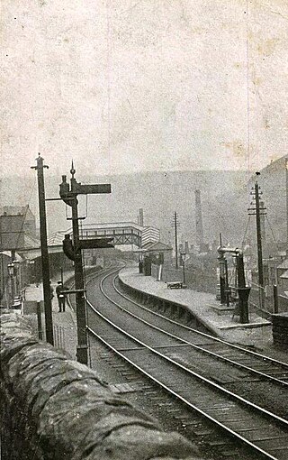
Abertillery railway station was a station which served Abertillery, in the Welsh county of Monmouthshire.

<span class="mw-page-title-main">Beaufort, Blaenau Gwent</span> Human settlement in Wales

Beaufort is a community and village located in the historic county of Brecknockshire (Breconshire) and the preserved county of Gwent. It currently lies on the northern edge of the county borough of Blaenau Gwent in Wales. According to the 2011 census, the population of the ward and community of Beaufort is 3,866

Nantyglo is a village in the ancient parish of Aberystruth and county of Monmouth situated deep within the South Wales Valleys between Blaina and Brynmawr in the county borough of Blaenau Gwent.

<span class="mw-page-title-main">Llanhilleth</span> Human settlement in Wales

Llanhilleth is a village, community and an electoral ward on the A467 road between Ebbw Vale and Crumlin in Blaenau Gwent, Wales.

The North Gwent Deanery, a Roman Catholic deanery in the Archdiocese of Cardiff in Wales, covers several churches in North Gwent and the surrounding area. In the early 2000s, the Head of the Valleys deanery was split. The churches in its western part, in the county boroughs of Merthyr Tydfi and Rhondda Cynon Taf, became part of the Pontypridd Deanery and the churches in its eastern part, in the county borough of Blaenau Gwent, became part of the North Gwent Deanery.

<span class="mw-page-title-main">Rassau</span> Human settlement in Wales

Rassau, sometimes The Rassau, is a village and community located in the historic county of Brecknockshire (Breconshire) and the preserved county of Gwent. It currently lies on the northern edge of the county borough of Blaenau Gwent in Wales. According to the 2011 census, the population of Rassau is 3,234. Residents often refer to either Old Rassau and New Rassau or Bottom Rassau and Top Rassau to distinguish the different parts of the village.

<span class="mw-page-title-main">Cwmtillery</span> Human settlement in Wales

Cwmtillery is a ward of Abertillery. Located within the historic boundaries of Monmouthshire, it is part of the administrative area of the county borough of Blaenau Gwent, Wales.

<span class="mw-page-title-main">Swffryd</span> Human settlement in Wales

Swffryd is a Welsh community on the boundary of Blaenau Gwent County Borough Council.

<span class="mw-page-title-main">Coalbrookvale</span> Human settlement in Wales

Coalbrookvale is a village in the Ebbw Valley in Blaenau Gwent. It belongs in the community of Nantyglo and Blaina.

References

  1. Wales illustrated, in a series of views, comprising the picturesque scenery, towns, castles, seats of the nobility & gentry, antiquities, &c. Gastineau, Henry, 1791-1876; Jones & Co., London, pub 1830
  2. "Monmouthshire parish map". Archived from the original on 2010-12-19. Retrieved 2010-11-07.
  3. Rev. Edmund Jones. A Geographical, Historical, and Religious Account of the parish of Aberystruth in the county of Monmouth. printed by The Family at Trevecka 1779
  4. A history of St Peter's church Blaina
  5. Star of Gwent (newspaper), 6 December 1856, page 8
  6. Brynmawr Heritage Trail, Blaenau Gwent County Borough Council