See also
| This disambiguation page lists articles associated with the title Abingdon Road. If an internal link led you here, you may wish to change the link to point directly to the intended article. |
Abingdon Road is a road in Oxford, England.
Abingdon Road may also refer to:
| This disambiguation page lists articles associated with the title Abingdon Road. If an internal link led you here, you may wish to change the link to point directly to the intended article. |
Abingdon may refer to:

Kensington is an affluent district in the Royal Borough of Kensington and Chelsea in the West End of central London.

Abingdon-on-Thames, known just as Abingdon between 1974 and 2012, is a historic market town and civil parish in the ceremonial county of Oxfordshire, England. Historically the county town of Berkshire, since 1974 Abingdon has been administered by the Vale of White Horse district within Oxfordshire.
Didcot is a railway town and civil parish in the ceremonial county of Oxfordshire and the historic county of Berkshire. Didcot is 15 miles (24 km) south of Oxford, 10 miles (16 km) east of Wantage and 15 miles (24 km) north west of Reading. The town is noted for its railway heritage, Didcot station opening as a junction station on the Great Western Main Line in 1844.
The Vale of White Horse is a local government district of Oxfordshire in England. South and west of the upper Thames, on its right bank it was long a north-west projection of Berkshire. The area is commonly referred to as the 'Vale of the White Horse' and is crossed by the Ridgeway National Trail in its far south, across the North Wessex Downs AONB at the junction of four counties. The 'White Horse' as a name and emblem features in sports clubs and organisations, but is also emblematic of Kent and appears in lesser known hill figures elsewhere.

Culham is a village and civil parish in a bend of the River Thames, 1 mile (1.6 km) south of Abingdon in Oxfordshire.

Didcot Parkway is a railway station serving the town of Didcot in Oxfordshire, England. The station was opened as Didcot on 12 June 1844 and renamed Didcot Parkway on 29 July 1985 by British Rail to reflect its role as a park and ride railhead. It is 53 miles 10 chains (85.5 km) down the line from London Paddington and is situated between Cholsey to the east and Swindon to the west.
Grandpont is a mainly residential area in south Oxford. It is west of Abingdon Road, and consists mainly of narrow streets that run at right-angles to the main road, with terraced late-Victorian and Edwardian houses.
The Cherwell Valley line is the railway line between Didcot and Banbury via Oxford. It links the Great Western Main Line and the south to the Chiltern Main Line and the Midlands. The line follows the River Cherwell for much of its route between Banbury and Oxford.

Drayton is a village and civil parish about 2 miles (3 km) south of Abingdon, Oxfordshire. It was part of Berkshire until the 1974 boundary changes transferred it to Oxfordshire. The parish includes the hamlet of Sutton Wick. The 2011 Census recorded the parish population as 2,353.
Junction station usually refers to a railway station situated on or close to a junction where lines to several destinations diverge. The usual minimum is three incoming lines. If we look at a station with platforms running from left to right, the minimum to qualify as a junction station would usually be one line on the left and two on the right.

Abingdon Road is the main arterial road to the south of the city of Oxford, England. The road passes through the suburbs of Grandpont and New Hinksey. It is named after the town of Abingdon to the south.

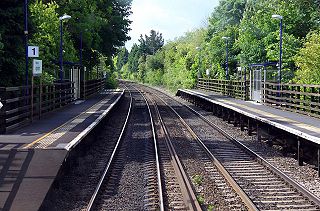
Culham railway station serves the village of Culham in Oxfordshire, England. It is on the Cherwell Valley Line between Didcot Parkway and Banbury, 56 miles 17 chains (90.5 km) from London Paddington. It is served by local train services provided by Great Western Railway.
Abingdon Boys School is a Japanese rock band formed in 2005 and fronted by Japanese singer Takanori Nishikawa.

Burnham-on-Sea railway station located within the town of Burnham-on-Sea, Somerset, was the terminus of the Burnham branch of the Somerset and Dorset Joint Railway. Opened as Burnham by the Somerset Central Railway on 3 May 1858, it was renamed in 1920.

Steventon is a village and civil parish in Oxfordshire, England, about 4 miles (6.4 km) south of Abingdon and a similar distance west of Didcot. It was part of Berkshire until the 1974 boundary changes transferred it to Oxfordshire. The 2011 Census recorded the parish population as 1,485.
Abingdon Junction railway station was a junction station for the branch line to Abingdon. It was opened by the Abingdon Railway Company on 2 June 1856 along with the branch, and was subsequently closed and replaced by Radley railway station on 8 September 1873. Radley station was in a more convenient place for access. At the same time as the station's opening, the next station to the south, formerly known as Abingdon Road was renamed Culham.
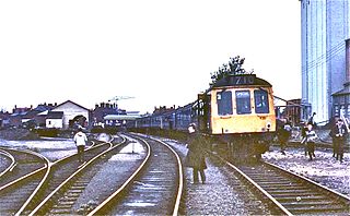
Abingdon railway station was a station which until 1963 served the town of Abingdon, then in Berkshire, now in Oxfordshire, in England.
Iffley Halt railway station was built by the Great Western Railway to serve Iffley, a suburb of Oxford; it was actually in Kennington, and not in Iffley.
Abingdon Road Halt railway station was built by the Great Western Railway to serve South Hinksey, a village near Oxford.