
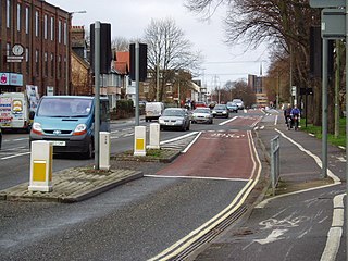
Abingdon Road is the main arterial road to the south of the city of Oxford, England. [1] [2] The road passes through the suburbs of Grandpont and New Hinksey. It is named after the town of Abingdon to the south.
Abingdon Road is the main arterial road to the south of the city of Oxford, England. [1] [2] The road passes through the suburbs of Grandpont and New Hinksey. It is named after the town of Abingdon to the south.
Part of the road was known as the Causey or Causy until the 17th century, after the Grandpont causeway that ran from St Aldate's to Hinksey Hill. [3]
To the north, the road crosses the River Thames at Folly Bridge and becomes St Aldate's, which leads to the centre of Oxford at Carfax, although the one-way system now prevents traffic from taking a direct route. The road is designated the A4144 and joins with the A423 dual carriageway that forms part of the Oxford Ring Road to the south.
At its southern end, the road turns sharply to the west and is known as Old Abingdon Road, crossing the Cherwell Valley railway line over a brick bridge to the south of which is the site of the former Abingdon Road Halt railway station. The bridge is known locally as the Red Bridge, and it has given its name to the area, in particular to Redbridge Park and Ride, and Redbridge Waste Recycling Facility.

The Duke of Monmouth public house is located on Abingdon Road. [4]
Abingdon Road forms part of the A4144 road. It was previously part of the A34 before the Oxford Ring Road was built.


Botley is a village in the civil parish of Botley and North Hinksey, in the Vale of White Horse district, in the county of Oxfordshire, England, just west of the Oxford city boundary. Historically part of Berkshire, it stands on the Seacourt Stream, a stream running off the River Thames. The intersection of the A34 and A420 is to the village's north.

Culham is a village and civil parish in a bend of the River Thames, 1 mile (1.6 km) south of Abingdon in Oxfordshire. The parish includes Culham Science Centre and Europa School UK. The parish is bounded by the Thames to the north, west and south, and by present and former field boundaries to the east. It is low-lying and fairly flat, rising from the Thames floodplain in the south to a north-facing escarpment in the north up to 260 feet (80 m) above sea level. The 2011 Census recorded its population as 453.

North Hinksey is a village in the civil parish of Botley and North Hinksey, in the Vale of White Horse district, in Oxfordshire, England, on the west side of the Thames flood plain immediately opposite the city of Oxford. The civil parish includes the large settlement of Botley, effectively an isolated suburb of Oxford, with the Botley Road as the sole highway link across the flood plain. North Hinksey was in all respects part of Berkshire until the 1974 boundary changes transferred administration of the Vale of White Horse district to Oxfordshire County Council; it remains part of the historic county of Berkshire however, since the 1974 act did not change the ancient county boundaries. The village of North Hinksey has a manor house, The Fishes public house, a Church of England primary school and a Church of England parish church, St. Lawrence's, which dates back to at least the 12th century. Four of the older houses have thatched roofs.
Grandpont is a mainly residential area in south Oxford. It is west of Abingdon Road, and consists mainly of narrow streets that run at right angles to the main road, with terraced late-Victorian and Edwardian houses.

Oxford railway station is a mainline railway station, one of two serving the city of Oxford, England. It is about 0.5 miles (800 m) west of the city centre, north-west of Frideswide Square and the eastern end of Botley Road. It is on the line for trains between London Paddington and Hereford via Worcester Shrub Hill. It is a starting point for fast and local trains to London Paddington and London Marylebone, and for local trains to Reading, Worcester, and Banbury. It is also on the north/south Cross Country Route from Manchester Piccadilly and Newcastle via Birmingham New Street and Reading to Southampton Central and Bournemouth. The station is managed by Great Western Railway, and also served by CrossCountry and Chiltern Railways trains. Immediately to the north is Sheepwash Channel Railway Bridge over the Sheepwash Channel.

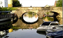
Folly Bridge is a stone bridge over the River Thames carrying the Abingdon Road south from the centre of Oxford, England. It was erected in 1825–27, to designs of a little-known architect, Ebenezer Perry, who practised in London.
St Aldate's is a street in central Oxford, England, named after Saint Aldate, but formerly known as Fish Street.
The Oxford Ring Road circles the city of Oxford, England. It is a dual carriageway ring road for most of its length apart from a short section between Woodstock Road and Banbury Road in the north of the city. The severe restrictions on traffic in Oxford city centre mean that it is the only practical way for long-distance traffic to get past Oxford, especially as there are few road bridges over the rivers Isis and Cherwell. Five Park and Rides are close to the ring road.
New Hinksey is a suburb in the south of the city of Oxford.
Hinksey is a place name associated with Oxford and Oxfordshire. In 1974, many of the places associated with the name were transferred from the county of Berkshire in the county boundary changes.

Hinksey Stream is a branch of the River Thames to the west of the city of Oxford, England. It starts as Seacourt Stream, which leaves the Thames at a bifurcation north of the village of Wytham, and rejoins the river south of the city near Kennington.
Botley Road is the main road into the centre of Oxford, England from the west. It stretches between Botley, on the Oxford Ring Road (A34) to the west of the city, and Frideswide Square at the junction with Oxford railway station, close to central Oxford.
Abingdon Junction railway station was a junction station for the branch line to Abingdon. It was opened by the Abingdon Railway Company on 2 June 1856 along with the branch, and was subsequently closed and replaced by Radley railway station on 8 September 1873. Radley station was in a more convenient place for access. At the same time as the station's opening, the next station to the south, formerly known as Abingdon Road was renamed Culham.

Oxpens Road is a road in central Oxford, England, linking west and south Oxford. It is named after the marshy area of Oxpens, next to one of the branches of the River Thames in Oxford. It forms part of the A420 road.

The A4144 road is an A road in Oxford, England. It links Upper Wolvercote in the north and Redbridge in the south via central Oxford.
Abingdon Road Halt railway station was built by the Great Western Railway to serve South Hinksey, a village near Oxford.
Hinksey Halt railway station was built by the Great Western Railway to serve New Hinksey, a suburb of Oxford.

Frideswide Square is a square to the west of central Oxford, England. The square is named after the patron saint of Oxford, St Frideswide.

Redbridge is located in south Oxford, England, at the southern end of Abingdon Road near the Oxford Ring Road. Redbridge takes its name from a brick bridge, locally known as the Red Bridge, which carries Old Abingdon Road over the Cherwell Valley railway line.
Stephen Salter was an English architect who practised in Oxford, Maidenhead, and the Isle of Wight. He should not be confused with another (unrelated) architect called Stephen Salter who lived from 1826 to 1896 and worked in London.
51°44′19″N1°15′10″W / 51.7385°N 1.2527°W
| | This Oxfordshire location article is a stub. You can help Wikipedia by expanding it. |
| | This England road or road transport-related article is a stub. You can help Wikipedia by expanding it. |