Folly Bridge

Last updated • 3 min readFrom Wikipedia, The Free Encyclopedia

Folly Bridge
Follybridge.jpg
Folly Bridge from downstream.
Coordinates 51°44′46″N1°15′24″W / 51.746027°N 1.256542°W / 51.746027; -1.256542
Crosses River Thames
Locale Oxford
Heritage status Grade II listed
Characteristics
MaterialStone
Height10 feet 3 inches (3.12 m) [1]
No. of spans3
Piers in water2
History
DesignerEbenezer Perry
Opened1827
Location
Folly Bridge
View of Folly Bridge and the island from downstream. River Isis (Thames), Oxford - geograph.org.uk - 164888.jpg
View of Folly Bridge and the island from downstream.

Folly Bridge is a stone bridge over the River Thames carrying the Abingdon Road south from the centre of Oxford, England. [2] It was erected in 1825–27, to designs of a little-known architect, Ebenezer Perry (died 1850), who practised in London. [3]

Contents

The bridge is in two parts separated by an island. The origin of the name is uncertain [4] although it has been suggested that it originated about 1650 after a tenant of Bacon's study. [5]

History

The old "Friar Bacon's Study". Friar Bacon's Study.jpg
The old "Friar Bacon's Study".
"Grand Pont" from upstream. Folly Bridge from the west.jpg
"Grand Pont" from upstream.
The island and "South Bridge" from upstream. FollyBridge03.JPG
The island and "South Bridge" from upstream.

The bridge apparently stands at the site of the ford over which oxen could be driven across the Isis, the ancient name of the Thames in the Oxford area. The first known stone bridge on the site was built by Robert d'Oilli in around 1085, but there was believed to be a wooden bridge in the time of Ethelred of Wessex. [5] Remains of the Saxon structure may still be seen beneath the present bridge.

Until the late 17th century the bridge was known as South Bridge, and formed part of a long causeway known as Grandpont, which stretched along most of the line of Abingdon Road. [6] In the 13th century, the alchemist Roger Bacon lived and worked at "Friar Bacon's Study" which stood across the north end of the bridge until 1779, when it was removed to widen the road. Samuel Pepys visited Bacon's study in 1669, noting: "So to Friar Bacon's study: I up and saw it, and gave the man 1s". In 1369, when there was a grant of pontage on "Grauntpount", the structure was said to be "so dangerous as to be well nigh impassable".

A toll-booth gateway tower used to straddle the approach to the bridge, which was on the Abingdon to Banbury turnpike. The former bridge and "Bacon's Tower" were drawn by many artists, including the twelve-year-old J. M. W. Turner. [7]

There was also a weir underneath the bridge which had a flash lock and later a "pen" lock. At the beginning of the 19th century this and the poor state of the bridge itself constituted a problem for navigation. Surveys discovered that the foundations were in a very bad state, and in 1815 an Act of Parliament was obtained to rebuild the bridge and remove the "Tackle and Works" underneath. The new bridge works were begun in 1824 and completed in 1827. A pound lock was established nearby in about 1832, which was removed in 1884. The bridge is Grade I listed. [8]

The toll house was rebuilt in 1844 and is now, along with the bridge, also Grade II listed; tolls on the bridge were abolished in 1850. [9] A scheme for a public footbridge next to the bridge was designed by Nicholas Grimshaw & Partners but was not built. [10]

Environs

Castellated house at Folly Bridge (in 1979). The house was built in 1849 for the mathematician Joshua Cardwell. Folly Bridge and battlemented house, Oxford - geograph.org.uk - 530126.jpg
Castellated house at Folly Bridge (in 1979). The house was built in 1849 for the mathematician Joshua Cardwell.

Robert Gunther, the historian of science, bought 5 Folly Bridge, an unusual castellated house by the bridge, in 1911. [11] The house is embellished with statues and cast iron balconies on the outside. It is located on a small island in the middle of the Thames.

Salters Steamers are located near the bridge. Punts are available close to the bridge and Christ Church Meadow is just downstream. The Head of the River public house is next to the bridge to the northeast, with views of the bridge and river.

Literature

Alice's Adventures in Wonderland originated as a story told on a boating trip which began at Folly Bridge. [12]

The novel Folly Bridge: A Romantic Tale was written by David Leslie Murray and published in 1945. [13] The 1970 book Last Boat to Folly Bridge was written by the sailor Eric C. Hiscock. [14]

Folly Bridge View of downstream River Thames, Oxford - May 2010.jpg
A panoramic view from Folly Bridge, looking downstream on the River Thames towards the Oxford University College boat houses.

See also

Related Research Articles

<span class="mw-page-title-main">River Thames</span> River in southern England

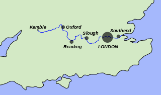
The River Thames, known alternatively in parts as the River Isis, is a river that flows through southern England including London. At 215 miles (346 km), it is the longest river entirely in England and the second-longest in the United Kingdom, after the River Severn.

<span class="mw-page-title-main">Locks and weirs on the River Thames</span>

The English River Thames is navigable from Cricklade or Lechlade to the sea, and this part of the river falls 71 meters (234 feet). There are 45 locks on the river, each with one or more adjacent weirs. These lock and weir combinations are used for controlling the flow of water down the river, most notably when there is a risk of flooding, and provide for navigation above the tideway.

<span class="mw-page-title-main">Marlow Bridge</span> Bridge in Marlow

Marlow Bridge is a road traffic and foot bridge over the River Thames in England between the town of Marlow, Buckinghamshire and the village of Bisham in Berkshire. It crosses the Thames just upstream of Marlow Lock, on the reach to Temple Lock. The bridge is a Grade I listed building.

<span class="mw-page-title-main">Teddington Lock</span> Series of locks on the River Thames in London

Teddington Lock is a complex of three locks and a weir on the River Thames between Ham and Teddington in the London Borough of Richmond upon Thames, England. Historically in Middlesex, it was first built in 1810.

<span class="mw-page-title-main">Bray Lock</span> Lock and weir on the River Thames in Buckinghamshire, England

Bray Lock is a lock and weir on the River Thames in England near Bray and Dorney Reach, and is just above the M4 Bridge across the Thames. The lock is on the Buckinghamshire side of the river on the opposite bank from Bray itself and Maidenhead which are in Berkshire. Here, the county line stands roughly halfway between the lock and the opposite bank, following the course of the Thames itself. The pound lock was built by the Thames Navigation Commission relatively late, in 1845. The lock keeper's cottage is on an island between the lock and the weir.

<span class="mw-page-title-main">Whitchurch Lock</span> Lock and weir on the River Thames in Oxfordshire, England

Whitchurch Lock is a lock and weir on the River Thames in England. It is a pound lock, built by the Thames Navigation Commissioners in 1787. It is on an island near the Oxfordshire village of Whitchurch-on-Thames and is accessible only by boat.

<span class="mw-page-title-main">Thames Path</span> National Trail following the River Thames in England

The Thames Path is a National Trail following the River Thames from one of its sources near Kemble in Gloucestershire to the Woolwich foot tunnel, south east London. It is about 185 miles (298 km) long. A path was first proposed in 1948 but it only opened in 1996.

<span class="mw-page-title-main">Sandford-on-Thames</span> Human settlement in England

Sandford-on-Thames, also referred to as simply Sandford, is a village and Parish Council beside the River Thames in Oxfordshire just south of Oxford. The village is just west of the A4074 road between Oxford and Henley.

<span class="mw-page-title-main">Thames Conservancy</span> United Kingdom legislation

The Thames Conservancy was a body responsible for the management of that river in England. It was founded in 1857 to replace the jurisdiction of the City of London up to Staines. Nine years later it took on the whole river from Cricklade in Wiltshire to the sea at Yantlet Creek on the Isle of Grain. Its territory was reduced when the Tideway was transferred to the Port of London Authority in 1909.

<span class="mw-page-title-main">Clifton Hampden Bridge</span> Bridge in Clifton Hampden, Oxfordshire

Clifton Hampden Bridge is a road bridge crossing the River Thames in Clifton Hampden, Oxfordshire, England, situated on the reach below Clifton Lock. Originally it joined Oxfordshire on the north bank with Berkshire on the south but in 1974 the area on the south bank was transferred from Berkshire to Oxfordshire. It is a Grade II* listed building.

<span class="mw-page-title-main">Iffley Lock</span> Lock on the River Thames in Oxfordshire, England

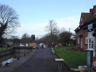
Iffley Lock is a lock on the River Thames in England near the village of Iffley, Oxfordshire. It is on the southern outskirts of Oxford. The original lock was built by the Oxford-Burcot Commission in 1631 and the Thames Navigation Commission replaced this in 1793. The lock has a set of rollers to allow punts and rowing boats to be moved between the water levels.

<span class="mw-page-title-main">Clifton Lock</span>

Clifton Lock is a lock on River Thames in Oxfordshire, England. It is located south of the village of Clifton Hampden and north of Long Wittenham. It is at the start of the Clifton Cut, which bypasses the river to the north of Long Wittenham. The lock was completed in 1822 by the Thames Navigation Commissioners.

<span class="mw-page-title-main">Flash lock</span> Gate in the flow of a river which could be opened to allow boats through

A flash lock is a type of lock for river or canal transport.

<span class="mw-page-title-main">Culham Lock</span> River lock in Oxfordshire, England

Culham Lock is a lock on the River Thames in England close to Culham, Oxfordshire. It is on a lock cut to the north of the main stream, which approaches the large village of Sutton Courtenay. The lock was built of stone by the Thames Navigation Commission in 1809.

<span class="mw-page-title-main">Abingdon Lock</span>

Abingdon Lock is a lock on the River Thames in England, less than 1 mile east and upstream of Abingdon, Oxfordshire, on the opposite bank of the river. It was originally built in 1790 by the Thames Navigation Commission.

<span class="mw-page-title-main">Osney Lock</span> Lock on the River Thames in Oxfordshire, England

Osney Lock is a lock on the River Thames in Oxford, England, where the village or island of Osney is next to the river.

<span class="mw-page-title-main">Eynsham Lock</span>

Eynsham Lock is a lock on the River Thames in England. It is on the southern bank near Swinford Oxfordshire. The large village of Eynsham is a little distance away on the northern bank.

<span class="mw-page-title-main">Swift Ditch</span> Artificial channel near Oxford, England

The Swift Ditch is a 2 km (1.2 mi) long artificial channel that formed a short-cut for river traffic to and from Oxford, across a meander of the River Thames in England. It was formerly the primary navigation channel. With the main river, it creates Andersey Island on the left bank of the Thames opposite Abingdon-on-Thames. Within a poem published in 1632, the Water Poet John Taylor wrote:

At Abingdon the shoals are worse and worse
That Swift Ditch seems to be the better course

<span class="mw-page-title-main">Culham Bridge</span> Bridge in Abingdon, Oxfordshire

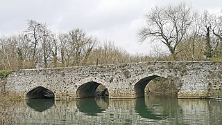
Culham Bridge is a medieval bridge crossing a present backwater of the River Thames in England at Culham, Oxfordshire, near the town of Abingdon. The bridge crosses Swift Ditch which was at one time the main navigation channel of the River Thames until Abingdon Lock was built in 1790. The bridge formerly carried the A415 road from Abingdon to Dorchester, Oxfordshire, but was superseded in 1928 by a modern road bridge.

References

  1. River Thames Alliance. Bridge heights on the River Thames.
  2. Hibbert, Christopher, ed. (1988). "Folly Bridge". The Encyclopaedia of Oxford . Macmillan. p. 144. ISBN   0-333-39917-X.
  3. Howard Colvin, A Biographical Dictionary of British Architects 1600-1840, 3rd ed., 1995 (Yale University Press), s.v. "Ebenezer Perry".
  4. The Gentleman's Magazine, August 1829:105, which gave an engraving of the old bridge and the tower reputed to contain the study of Roger Bacon.
  5. 1 2 Fred. S. Thacker The Thames Highway: Volume II Locks and Weirs 1920 — republished 1968 David & Charles
  6. Victoria County History of Oxfordshire, Volume 4: Communications: Bridges
  7. "Folly Bridge and Bacon's Tower, Oxford 1787", pen and ink and watercolour, Tate Gallery.
  8. Historic England. "FOLLY BRIDGE WITH FORMER TOLL HOUSE (1319913)". National Heritage List for England . Retrieved 17 June 2015.
  9. Geoffrey Phillips (1981). Thames Crossings. Newton Abbot: David & Charles. pp.  49-56. ISBN   0-7153-8202-0.
  10. Grimshaw. Folly Bridge, 1996.
  11. A. V. Simcock (editor), Robert T. Gunther and the Old Ashmolean. Oxford: Museum of the History of Science, 1985, page 60.
  12. Gardner, Martin (2000). The Annotated Alice: the definitive edition. New York and London: W. W. Norton & Company. ISBN   0-393-04847-0.
  13. D. L. Murray, Folly Bridge: A Romantic Tale . London: Hodder and Stoughton, 1945.
  14. Eric C. Hiscock, Last Boat to Folly Bridge . Littlehampton Book Services Ltd, 1970. ISBN   978-0-304-93556-7.
Next crossing upstream River Thames Next crossing downstream
Grandpont Bridge Folly Bridge
Grid reference SP5143805559
Donnington Bridge