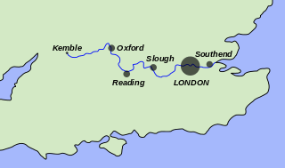
The River Thames, known alternatively in parts as the River Isis, is a river that flows through southern England including London. At 215 miles (346 km), it is the longest river entirely in England and the second-longest in the United Kingdom, after the River Severn.

Iffley is a village in a designated Conservation Area in Oxfordshire, England. It lies within the boundaries of the city of Oxford, between Cowley and the estates of Rose Hill and Donnington, and in proximity to the River Thames (Isis). A notable feature is its largely unchanged Norman church, St Mary the Virgin, which has a modern stained glass Nativity window designed by John Piper and another window designed by Roger Wagner. The church is a Grade I listed building.

Teddington Lock is a complex of three locks and a weir on the River Thames between Ham and Teddington in the London Borough of Richmond upon Thames, England. Historically in Middlesex, it was first built in 1810.
This article lists the islands in the River Thames, or at the mouth of a tributary, in England. It excludes human-made islands built as part of the building of forty-five two-gate locks which each accompany a weir, and islets subordinate to and forming part of the overall shape of another. The suffix -ey is common across England and Scotland and cognate with ait and meaning island, a term – as ait or eyot – unusually well-preserved on the Thames. A small minority of list entries are referred to as Island, Ait or Eyot and are vestiges, separated by a depression in the land or high-water-level gully.

The Thames Path is a National Trail following the River Thames from one of its sources near Kemble in Gloucestershire to the Woolwich foot tunnel, south east London. It is about 185 miles (298 km) long. A path was first proposed in 1948 but it only opened in 1996.
Chiswick Bridge is a reinforced concrete deck arch bridge over the River Thames in West London. It is one of three bridges opened in 1933 as part of an ambitious scheme to relieve traffic congestion west of London. The structure carries the A316 road between Chiswick on the north bank of the Thames and Mortlake on the south bank.

"The Isis" is an alternative name for the River Thames, used from its source in the Cotswolds until it is joined by the Thame at Dorchester in Oxfordshire. It derives from the ancient name for the Thames, Tamesis, which in the Middle Ages was believed to be a combination of "Thame" and "Isis". Notably, the Isis flows through the city of Oxford.
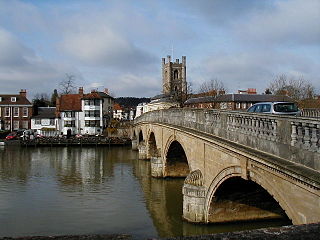
Henley Bridge is a road bridge built in 1786 at Henley-on-Thames over the River Thames, between Oxfordshire and Berkshire. The bridge has five elliptical stone arches, and links Hart Street in Henley with White Hill leading up a steep hill to Remenham Hill. It crosses the Thames on the reach between Hambleden Lock and Marsh Lock, carrying the Thames Path across the river. It is a Grade I listed building.

Sandford-on-Thames, also referred to as simply Sandford, is a village and Parish Council beside the River Thames in Oxfordshire just south of Oxford. The village is just west of the A4074 road between Oxford and Henley.

Iffley Lock is a lock on the River Thames in England near the village of Iffley, Oxfordshire. It is on the southern outskirts of Oxford. The original lock was built by the Oxford-Burcot Commission in 1631 and the Thames Navigation Commission replaced this in 1793. The lock has a set of rollers to allow punts and rowing boats to be moved between the water levels.

Shepperton Lock is a lock on the River Thames, in England by the left bank at Shepperton, Surrey. It is across the river from Weybridge which is nearby linked by a passenger ferry.
Donnington is a small housing estate in Oxford, England located adjacent to the River Thames in the post-war housing developments either side of Donnington Bridge and around Boundary Brook Road. It is bordered by Iffley Village to the south, Iffley Fields to the north and Cowley to the east.

Sunbury Lock is a lock complex of the River Thames in England near Walton-on-Thames in north-west Surrey, the third lowest of forty four on the non-tidal reaches. The complex adjoins the right, southern bank about 1⁄2 mile (0.80 km) downstream of the Weir Hotel.

Sandford Lock is a lock on the River Thames in England, situated at Sandford-on-Thames which is just south of Oxford. The first pound lock was built in 1631 by the Oxford-Burcot Commission although this has since been rebuilt. The lock has the deepest fall of all locks on the Thames at 8 ft 9in (2.69m) and is connected to a large island which is one of three at this point. The lock lies at the end of Church Lane in Sandford on Thames.

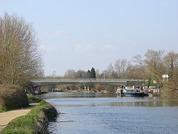
Isis Bridge is a modern road bridge across the River Thames just south of Oxford, England. It carries the Oxford Ring Road, part of the A423 road, across the Thames on the reach between Sandford Lock and Iffley Lock.
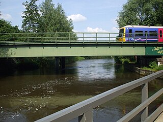
Osney Rail Bridge is a railway bridge over the River Thames at Oxford in England. It carries the Cherwell Valley Line between Didcot and Oxford across the river on the reach between Iffley Lock and Osney Lock.
The Swift Ditch is a 2 km (1.2 mi) long artificial channel that formed a short-cut for river traffic to and from Oxford, across a meander of the River Thames in England. It was formerly the primary navigation channel. With the main river, it creates Andersey Island on the left bank of the Thames opposite Abingdon-on-Thames. Within a poem published in 1632, the Water Poet John Taylor wrote:
At Abingdon the shoals are worse and worse
That Swift Ditch seems to be the better course

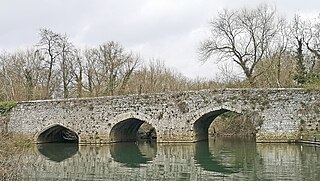
Culham Bridge is a medieval bridge crossing a present backwater of the River Thames in England at Culham, Oxfordshire, near the town of Abingdon. The bridge crosses Swift Ditch which was at one time the main navigation channel of the River Thames until Abingdon Lock was built in 1790. The bridge formerly carried the A415 road from Abingdon to Dorchester, Oxfordshire, but was superseded in 1928 by a modern road bridge.

Donnington Bridge Road is a road in south Oxford, England, in the estate of Donnington.