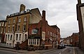
Greyfriars is a Roman Catholic friary and parish located in East Oxford, which until 2008 was also a permanent private hall of the University of Oxford. Situated on the Iffley Road in East Oxford, it was one of the smallest constituent halls of the university. Its status as a permanent private hall (PPH) derived from the fact that it was governed by an outside institution, rather than by the fellows of the University as a constituent college is.

Stellenbosch is a town in the Western Cape province of South Africa, situated about 50 kilometres east of Cape Town, along the banks of the Eerste River at the foot of the Stellenbosch Mountain. The town became known as the City of Oaks or Eikestad in Afrikaans and Dutch due to the large number of oak trees that were planted by its founder, Simon van der Stel, to grace the streets and homesteads.

Uitenhage, officially renamed Kariega, is a South African town in the Eastern Cape Province. It is well known for the Volkswagen factory located there, which is the biggest car factory on the African continent. Along with the city of Port Elizabeth and the small town of Despatch, it forms the Nelson Mandela Bay Metropolitan Municipality.
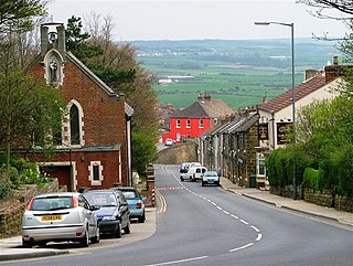
Saltburn-by-the-Sea, commonly referred to as Saltburn, is a seaside town in the civil parish of Saltburn, Marske and New Marske, in the Redcar and Cleveland district, in North Yorkshire, England, 12 miles (19 km) south-east of Hartlepool and 5 miles (8 km) south-east of Redcar. It lies within the historic boundaries of the North Riding of Yorkshire. It had a population of 5,958 in 2011.

St Edward's School is a public school in Oxford, England. It is known informally as 'Teddies'.

The Diocesan College is a private, English medium, boarding and day high school for boys situated in the suburb of Rondebosch in Cape Town in the Western Cape province of South Africa. The school was established on 2 October 1849 by the Anglican Bishop of Cape Town.
Brotton is a village in the civil parish of Skelton and Brotton, in the Redcar and Cleveland district, in the ceremonial county of North Yorkshire, England It is situated approximately 2.5 miles (4 km) south-east of Saltburn-by-the-Sea, 9 miles from Redcar, 12 miles (19 km) east of Middlesbrough and 14 miles (23 km) north-west of Whitby.
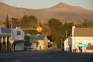
Cradock, officially Nxuba, is a town in the Eastern Cape Province of South Africa, in the upper valley of the Great Fish River, 250 kilometres (160 mi) by road northeast of Port Elizabeth. The town is the administrative seat of the Inxuba Yethemba Local Municipality in the Chris Hani District of the Eastern Cape.

Sandford-on-Thames, also referred to as simply Sandford, is a village and Parish Council beside the River Thames in Oxfordshire just south of Oxford. The village is just west of the A4074 road between Oxford and Henley.

Constantia is an affluent suburb of Cape Town, South Africa, situated about 15 kilometres south of the centre of Cape Town. It is considered to be one of the most prestigious suburbs in South Africa. The Constantia Valley lies to the east of and at the foot of the Constantiaberg mountain. Constantia Nek is a low pass linking to Hout Bay in the west.

Parks Road is a road in Oxford, England, with several Oxford University colleges along its route. It runs north–south from the Banbury Road and Norham Gardens at the northern end, where it continues into Bradmore Road, to the junction with Broad Street, Holywell Street and Catte Street to the south.

The Plain is an important junction, now a roundabout constructed in 1950, just east of Magdalen Bridge in Oxford, England. To the east and southeast are St Clement's, Cowley Road and Iffley Road which leads to the Liddell Buildings of Christ Church on the other side of the Christ Church Meadow. Magdalen College School is to the south. Cowley Place, also to the south, leads to St Hilda's College, the most easterly college of the University of Oxford.
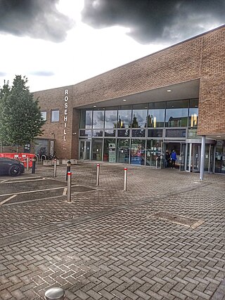
Rose Hill is a residential area, with some housing that has been council-owned, on the southern outskirts of Oxford, England. According to the 2001 Census, the population of Rose Hill and the adjoining village of Iffley was 4,667.
Marston Ferry Road is a link road in north Oxford, England. It is named after the ferry that used to cross the River Cherwell at the village of Marston from at least 1279.

Bradmore Road is a residential road in North Oxford, England.
Charles Abdy Marcon was an English clergyman, Master of Marcon's Hall, a private hall of Oxford University, from 1891 to 1918, then from 1918 Vicar of Kennington in south London.
Gillotts School is a coeducational secondary school with academy status in Henley-on-Thames, Oxfordshire, England. The school is sited on a 33 acre verdant campus on the edge of Henley, incorporating a large Victorian manor house and two of its associated cottages. There are extensive playing fields, as well as areas of grass, trees and woodland.

Iffley Road rugby football ground is a playing-field in Oxford, England. It is the home of Oxford University Rugby Football Club and between 2013 and 2016 was the home of semi-professional Oxford Rugby League. It is close to the Roger Bannister running track.
The Oxfordshire RFU County Cup is an annual rugby union knock-out club competition organised by the Oxfordshire Rugby Football Union. It was first introduced during the 1970–71 season, with the inaugural winners being Oxford. It is the most important rugby union cup competition in Oxfordshire, ahead of the Oxfordshire RFU County Shield.

Saltburn is a 2023 black comedy psychological thriller film written, directed, and co-produced by Emerald Fennell, starring Barry Keoghan, Jacob Elordi, Rosamund Pike, Richard E. Grant, Alison Oliver, and Archie Madekwe. Set in Oxford and Northamptonshire, it focuses on a student at Oxford who becomes fixated with a popular, aristocratic fellow student, who later invites him to spend the summer at his eccentric family's estate.