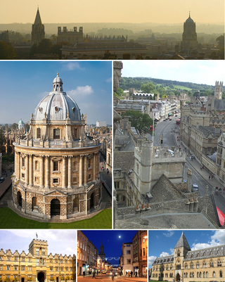
Oxford is a city in England. It is the county town and only city of Oxfordshire. It had a population of 162,100 at the 2021 census. It is 56 miles (90 km) north-west of London, 64 miles (103 km) south-east of Birmingham and 61 miles (98 km) north-east of Bristol. The city is home to the University of Oxford, the oldest university in the English-speaking world; it has buildings in every style of English architecture since late Anglo-Saxon. Oxford's industries include motor manufacturing, education, publishing, information technology and science.

Iffley is a village in a designated Conservation Area in Oxfordshire, England. It lies within the boundaries of the city of Oxford, between Cowley and the estates of Rose Hill and Donnington, and in proximity to the River Thames (Isis). A notable feature is its largely unchanged Norman church, St Mary the Virgin, which has a modern stained glass Nativity window designed by John Piper and another window designed by Roger Wagner. The church is a Grade I listed building.

Cowley Road is an arterial road in the city of Oxford, England, running southeast from near the city centre at The Plain near Magdalen Bridge, through the inner city area of East Oxford, and to the industrial suburb of Cowley. The central shopping is at 51.746°N 1.232°W

Oxford East is a constituency represented in the House of Commons of the UK Parliament by Anneliese Dodds of the Labour Party, who also serves as party chair.

The A420 is a road between Bristol and Oxford in England. Between Swindon and Oxford it is a primary route.

Sandford-on-Thames, also referred to as simply Sandford, is a village and Parish Council beside the River Thames in Oxfordshire just south of Oxford. The village is just west of the A4074 road between Oxford and Henley.
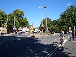
St Giles' is a wide boulevard leading north from the centre of Oxford, England. At its northern end, the road divides into Woodstock Road to the left and Banbury Road to the right, both major roads through North Oxford. At the southern end, the road continues as Magdalen Street at the junction with Beaumont Street to the west. Also to the west halfway along the street is Pusey Street. Like the rest of North Oxford, much of St Giles' is owned by St John's College.
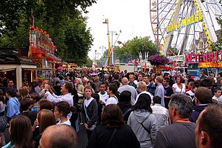
St Giles' Fair is an annual fair held in St Giles', a wide thoroughfare in central north Oxford, England. The origins of the fair can be traced back to medieval times where it became one of England's dynamic trading centers. The fair has survived medieval times and is organised for a two-day duration in September each year by the Oxford City Council with the London and Home Counties section of the Showmen's Guild of Great Britain.

Longwall Street is a street in central Oxford, England. It runs for about 300 metres along the western flank of Magdalen College. A high, imposing 15th century stone wall separates the college from the street along its entire length. Behind part of the wall is the college's deer park. The street is actually named after the old city wall to the west of the street, now largely hidden in the grounds of New College.

St Clement's is a district in Oxford, England, on the east bank of the River Cherwell. "St Clement's" is usually taken to describe a small triangular area from The Plain bounded by the Cherwell in the West, Cowley Road in the East. to the foot of Headington Hill in the South. It also refers to the ecclesiastical parish of St Clement's which includes some neighbouring areas and is used in the names of local City and County electoral districts.

Marston Road is a road in the east of Oxford, England. It links London Place, the junction of St Clements, the foot of Headington Hill, and Morrell Avenue by South Park to the south with the suburb of New Marston to the north. A mini-roundabout has been replaced by traffic lights and connects with Cherwell Drive and Headley Way at the northern end. To the north is the suburb of Northway. The road is designated the B4150 but this is not shown on signs.

Milham Ford School was a girls' secondary school in Oxford, England, located in the suburb of New Marston on Marston Road. It was founded in East Oxford in the 1880s and closed in 2003.

St John the Evangelist Church is a non-parochial church on Iffley Road in Oxford, England. It was built as the community church of the mother house of the Anglican religious order known as the Society of St. John the Evangelist. Since 1980 it has served also as one of the college chapels of St Stephen's House, Oxford.
St Clement's Church is an evangelical Church of England parish church situated just to the east of central Oxford, England.

Christ Church Ground is a cricket ground in Oxford, England. The ground is owned by Christ Church, a constituent college of the University of Oxford. Privately owned, it was the preferred venue in Oxford for matches where a gated admission was to be levied on spectators, typically in matches between Oxford University and a touring international team. The ground was a first-class cricket venue from 1878 to 1961, hosting 37 first-class matches. After 1961, the University Parks became the preferred venue for all first-class matches in Oxford, but it remained in use in minor counties and one-day cricket by Oxfordshire until the start of the 21st century and hosted a Women's One Day International during the 1993 Women's Cricket World Cup.
Thomas Lawrence Dale, FRIBA, FSA was an English architect. Until the First World War he concentrated on designing houses for private clients. From the 1930s Dale was the Oxford Diocesan Surveyor and was most noted for designing, restoring, and furnishing Church of England parish churches.

The City of Oxford and District Tramway Company and its successor the City of Oxford Electric Traction Company operated a horse-drawn passenger tramway service in Oxford between 1881 and 1914. The tramway was unusual for having a track gauge of only 4 feet (1.219 m).

Church Cowley Road is a major road in Cowley, Oxford, England, leading from Rose Hill to Cowley Centre. It continues as Between Towns Road.

The following is a timeline of the history of the city, university and colleges of Oxford, England.
