Iffley Lock

Last updated

Iffley Lock
IffleyLock01.JPG
Iffley Lock from downstream
Waterway River Thames
County Oxfordshire
Maintained by Environment Agency
OperationHydraulic
First built1631
Latest built1927
Length46.96 m (154 ft 1 in) [1]
Width6.47 m (21 ft 3 in) [1]
Fall0.81 m (2 ft 8 in) [1]
Above sea level178'
Distance to
Teddington Lock
91 miles
Coordinates 51°43′42.45″N1°14′25.21″W / 51.7284583°N 1.2403361°W / 51.7284583; -1.2403361
Iffley Lock
BSicon uexSTR.svg
BSicon POINTERg@fq.svg
BSicon uSTR.svg
River Thames
BSicon uexSTR.svg
BSicon uWEIRr.svg
BSicon uexSTR+r.svg
weir
BSicon uexSTR.svg
BSicon uWEIRr.svg
BSicon uexABZg+r.svg
weir
BSicon uexSTR.svg
BSicon uLock5.svg
BSicon uexABZg+l.svg
Godstow Lock
BSicon POINTERg@fq.svg
BSicon uexSTR.svg
BSicon ueABZg+l.svg
BSicon uexSTRr.svg
Seacourt Stream
BSicon uexSTR.svg
BSicon uSTR.svg
--
BSicon uexSTR.svg
BSicon uSTR.svg
BSicon uFABZq+lr.svg
Oxford Canal
BSicon uexSTR.svg
BSicon uSTR.svg
BSicon uLock5.svg
BSicon uexSTR+l.svg
BSicon uexABZgr.svg
BSicon ueABZgl.svg
BSicon emKRZo.svg
BSicon ueABZg+r.svg
Castle Mill Stream
BSicon uexSTR.svg
BSicon uexABZg+l.svg
BSicon uexABZq+l.svg
BSicon uWEIRl.svg
BSicon uFABZgl+l.svg
BSicon mKRZo.svg
BSicon uxABZgr.svg
Sheepwash Channel
BSicon uexSTR.svg
BSicon uexSTR.svg
BSicon uexSTR.svg
BSicon uSTR.svg
BSicon BHF.svg
BSicon uxWEIRg.svg
Oxford station
BSicon uexSKRZ-Au.svg
BSicon uSKRZ-Au.svg
BSicon SKRZ-Ao.svg
BSicon uexSKRZ-Au.svg
A420 Botley Road
BSicon uexSTR.svg
BSicon uexSTR.svg
BSicon uexSTR.svg
BSicon ueABZgl.svg
BSicon uexSTR+r.svg
BSicon uexSTR.svg
BSicon uexSTR.svg
BSicon uexSTR.svg
BSicon uexABZg+l.svg
BSicon uWEIRl.svg
BSicon uexSTR.svg
BSicon uexSTR.svg
BSicon uexSTR.svg
BSicon uexSTR.svg
BSicon uexSTR.svg
BSicon uLock5.svg
BSicon ueMILL.svg
BSicon uexSTR.svg
Osney Lock and mill
BSicon uexSTR.svg
BSicon uexSTR.svg
BSicon uexSTRl.svg
BSicon ueABZg+r.svg
BSicon uddSTRr.svg
BSicon uexSTR.svg
moorings
BSicon uexSTR.svg
BSicon uexSTR.svg
BSicon uABZg+l.svg
BSicon uSTRr.svg
BSicon uexSTR.svg
BSicon uexSTR.svg
BSicon uexSTR.svg
BSicon uSTR.svg
BSicon uexSTR.svg
BSicon uexSTR.svg
BSicon POINTERg@fq.svg
BSicon uexSTR.svg
BSicon uSTR.svg
BSicon uexSTR.svg
BSicon uexABZg+l.svg
BSicon uexABZlr.svg
BSicon uexSTRq.svg
BSicon uxABZql.svg
BSicon mKRZo.svg
BSicon uxABZg+r.svg
Osney Rail Bridge
BSicon uxWEIRg.svg
BSicon uSKRZ-Au.svg
A4144 Folly Bridge
BSicon uexSTRl.svg
BSicon uexSTRq.svg
BSicon uexSTR+r.svg
BSicon ueABZg+l.svg
River Cherwell
BSicon STR+l.svg
BSicon uxmKRZu.svg
BSicon STRr.svg
BSicon uSTR+l.svg
BSicon uSTRr.svg
Railway bridge
BSicon uexSTR.svg
BSicon uexSTR+l.svg
BSicon uWEIRl.svg
weir
BSicon uexSTR.svg
BSicon uexSKRZ-Yu.svg
BSicon uSKRZ-Yu.svg
B4495 Donnington Bridge
BSicon uexABZg+l.svg
BSicon uexSTRr.svg
BSicon uSTR.svg
BSicon uexSTR.svg
BSicon uSTR+l.svg
BSicon uABZgrxl.svg
BSicon uexSTR+r.svg
BSicon uexSTR.svg
BSicon uPLANEu.svg
BSicon uLock5.svg
BSicon uxWEIRg.svg
Iffley Lock and rollers
BSicon uexSTR.svg
BSicon uSTR.svg
BSicon ueABZg+l.svg
BSicon uexSTRr.svg
BSicon POINTERg@fq.svg
BSicon uexSTR.svg
BSicon uSTRl.svg
BSicon uABZg+r.svg
Hinksey Stream
BSicon uexSKRZ-Au.svg
BSicon RAq.svg
BSicon uSKRZ-Au.svg
A423 Isis Bridge
BSicon uexSTRl.svg
BSicon uexSTRq.svg
BSicon ueABZg+r.svg
BSicon uSTR.svg
River Thames

Iffley Lock is a lock on the River Thames in England near the village of Iffley, Oxfordshire. It is on the southern outskirts of Oxford. The original lock was built by the Oxford-Burcot Commission in 1631 and the Thames Navigation Commission replaced this in 1793. The lock has a set of rollers to allow punts and rowing boats to be moved between the water levels.

Contents

In addition the lock and weir streams there is stream further to the east which used to be the Mill Stream.

The weir is downstream of the lock, where the weir stream is joined by the mill stream.

History

A weir was owned by Lincoln College as early as 1302 and this weir may have carried the bridge which is referenced earlier than this. Iffley Lock was the pound lock furthest upstream that was built by the Oxford-Burcot Commission in 1631. In 1790 the Thames Commissioners took over Iffley and the other Oxford-Burcot locks at Sandford and Swift Ditch. The Commission rebuilt the lock in 1793, and the keeper was instructed to take tolls for "punts, pleasure boats, skiffs and wherries" at a charge of sixpence for punts and skiffs and one shilling for four oared craft. However access to the lock was awkward for barge traffic heading for the Thames and Severn Canal which had to enter backwards and take down their masts. Improvements and enlargements were made to the lock in 1802 and 1806 and the stone lockhouse was built in 1810. In 1826, it was ordered that no craft should pass through the lock during the hours of divine service. In the middle of the 19th century there was a problem with water levels below the water and a witness to a parliamentary enquiry reported that cows and horses were sometimes driven into the river to create sufficient draught. The lock was repaired in 1866, and ten years later the lock was being blamed for flooding in Oxford. Although the boat slide was promised in 1885, at the same time the Thames Conservancy were considering removing the lock. However there were many petitions to retain it and it survived. [2]

Starting Ring presented to OUBC by Lord Desborough 1924 Starting Ring presented to OUBC by Lord Desborough 1924.jpg
Starting Ring presented to OUBC by Lord Desborough 1924

The latest rebuilding took place in 1927.

Access to the lock

The lock can be reached on foot on the track from Donnington Bridge on the western side or from Iffley village on the eastern side. The lock can be crossed on foot.

Reach above the lock

College boathouses and Christ Church Meadow OUCollegeBHs01.JPG
College boathouses and Christ Church Meadow
Housing above Folly Bridge IffleyReach02.JPG
Housing above Folly Bridge

The river at this point and around Oxford in general is sometimes known as the Isis. Donnington Bridge crosses the river upstream of the lock and then the River Cherwell joins the Thames on the northern side. Boathouses of Oxford University colleges line the bank on the northern side, followed by Christ Church Meadow. This upstream stretch of the river is used for rowing, and is the location of the University rowing regattas of Torpids and Summer Eights. After Christ Church Meadow is Folly Bridge where are the landing stages for pleasure boats. After Folly Bridge, the river runs through suburbs where it is crossed by Grandpont Bridge. Beyond this is the Gasworks Bridge, a converted railway bridge, and the Osney Rail Bridge.

The Thames Path stays on the western side towards South Hinksey until it reaches Osney Lock.

See also

The lock from upstream IffleyLock03.JPG
The lock from upstream

Related Research Articles

<span class="mw-page-title-main">Locks and weirs on the River Thames</span>

The English River Thames is navigable from Cricklade or Lechlade to the sea, and this part of the river falls 71 meters (234 feet). There are 45 locks on the river, each with one or more adjacent weirs. These lock and weir combinations are used for controlling the flow of water down the river, most notably when there is a risk of flooding, and provide for navigation above the tideway.

<span class="mw-page-title-main">Teddington Lock</span> Series of locks on the River Thames in London

Teddington Lock is a complex of three locks and a weir on the River Thames between Ham and Teddington in the London Borough of Richmond upon Thames, England. Historically in Middlesex, it was first built in 1810.

<span class="mw-page-title-main">Bray Lock</span> Lock and weir on the River Thames in Buckinghamshire, England

Bray Lock is a lock and weir on the River Thames in England near Bray and Dorney Reach, and is just above the M4 Bridge across the Thames. The lock is on the Buckinghamshire side of the river on the opposite bank from Bray itself and Maidenhead which are in Berkshire. Here, the county line stands roughly halfway between the lock and the opposite bank, following the course of the Thames itself. The pound lock was built by the Thames Navigation Commission relatively late, in 1845. The lock keeper's cottage is on an island between the lock and the weir.

<span class="mw-page-title-main">Hambleden Lock</span> Lock on the River Thames in Berkshire, England

Hambleden Lock is a lock with a long weir situated on the River Thames in England, about 2 miles downstream of Henley Bridge. The lock is on the Berkshire bank between Aston and Remenham. Built by the Thames Navigation Commission in 1773, the lock is named after the village of Hambleden, a mile (1.5 km) to the north.

<span class="mw-page-title-main">Donnington Bridge</span> Bridge in Oxford

Donnington Bridge is a modern road bridge over the River Thames, in the south of the city of Oxford, England. At this point the river is commonly called the Isis. The bridge carries the B4495 road from Abingdon Road to Iffley Road. It crosses the river on the reach between Iffley Lock and Osney Lock.

<span class="mw-page-title-main">Shepperton Lock</span> Lock on the River Thames in Surrey, England

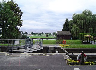
Shepperton Lock is a lock on the River Thames, in England by the left bank at Shepperton, Surrey. It is across the river from Weybridge which is nearby linked by a passenger ferry.

The Oxford-Burcot Commission was the first Commission concerned with the management of the River Thames, appointed by an Act of Parliament of 1605 by James I to make the stretch of river from Burcot to Oxford navigable. The Commission took responsibility for the management of the River Thames between Oxford and Burcot. It consisted of 18 members, including a representative each from Oxford city and from the University. However its work was irregular and by 1611 it had ceased altogether.

<span class="mw-page-title-main">Molesey Lock</span> Lock on the River Thames in Surrey, England

Molesey Lock is a lock on the River Thames in England at East Molesey, Surrey on the right bank.

<span class="mw-page-title-main">Marlow Lock</span> Lock and weir on the River Thames in Buckinghamshire, England

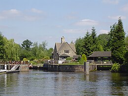
Marlow Lock is a lock and weir situated on the River Thames in the town of Marlow, Buckinghamshire, England, about 300m downstream of Marlow Bridge. The first pound lock was built by the Thames Navigation Commission in 1773.

<span class="mw-page-title-main">Sunbury Lock</span> Lock on the River Thames in Surrey, England

Sunbury Lock is a lock complex of the River Thames in England near Walton-on-Thames in north-west Surrey, the third lowest of forty four on the non-tidal reaches. The complex adjoins the right, southern bank about 12 mile (0.80 km) downstream of the Weir Hotel.

<span class="mw-page-title-main">Chertsey Lock</span> Lock on the River Thames in Surrey, England

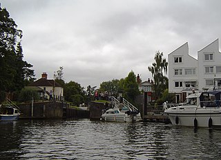
Chertsey Lock is a lock on the River Thames in England, against the left bank, an area of Green Belt including Laleham Park, the largest public park in Spelthorne. It faces the town of Chertsey and is the fifth-lowest of the forty-four locks along the non-tidal course of the river. Owing to a course alteration both banks at the site of the lock have been since medieval times in Surrey. Stone-built Chertsey Bridge built in 1785 is 210 m south (downstream) of the lock. The lock was built by the City of London Corporation in 1813, lengthened in 1893 and again in 1913.

<span class="mw-page-title-main">Bell Weir Lock</span> Lock on the River Thames in England

Bell Weir Lock is a lock on the River Thames in England by the right bank, Runnymede which is a water meadow associated with Egham of importance for the constitutional Magna Carta. It is upstream of the terrace of a hotel and the a bridge designed by Edwin Lutyens who designed an ornamental park gate house along the reach. The bridge has been widened and carries the M25 and A30 road across the river in a single span. The lock was first built by the Thames Navigation Commission in 1817; it has one weir which is upstream. The lock is the eighth lowest of forty-five on the river and is named after the founder of the forerunner of the adjoining hotel who took charge of the lock and weir on its construction.

<span class="mw-page-title-main">Romney Lock</span> Lock on the River Thames in Berkshire, England

Romney Lock is a lock on the River Thames in England near Windsor and Eton, about half a mile downstream of Windsor Bridge. It is on the Windsor side of the river next to a boatyard and adjoins Romney Island, a long strip-shaped ait in the middle of the river. The first lock was built by the Thames Navigation Commission in 1798.

<span class="mw-page-title-main">Boveney Lock</span> Lock on the River Thames in Buckinghamshire, England

Boveney Lock is a lock on the River Thames situated on the Buckinghamshire bank opposite the Windsor Racecourse and close to Eton Wick. Boveney is a village a little way upstream on the same side. The lock was first built in 1838 by the Thames Navigation Commission. The lock was rebuilt in 1898 closer to the Buckinghamshire bank, and a set of boat rollers were installed on the old site.

<span class="mw-page-title-main">Cleeve Lock</span> Lock on the River Thames in Oxfordshire, England

Cleeve Lock is a lock on the River Thames, in Oxfordshire, England. It is located just upstream of Goring and Streatley villages, on the eastern side of the river within the village of Goring. There was a hamlet of Cleeve, after which the lock is named, but it dropped out of use, as always part of Goring.

<span class="mw-page-title-main">Abingdon Lock</span>

Abingdon Lock is a lock on the River Thames in England, less than 1 mile east and upstream of Abingdon, Oxfordshire, on the opposite bank of the river. It was originally built in 1790 by the Thames Navigation Commission.

<span class="mw-page-title-main">Sandford Lock</span> Lock in Oxfordshire, South East England, England, UK

Sandford Lock is a lock on the River Thames in England, situated at Sandford-on-Thames which is just south of Oxford. The first pound lock was built in 1631 by the Oxford-Burcot Commission although this has since been rebuilt. The lock has the deepest fall of all locks on the Thames at 8 ft 9in (2.69m) and is connected to a large island which is one of three at this point. The lock lies at the end of Church Lane in Sandford on Thames.

<span class="mw-page-title-main">Osney Lock</span> Lock on the River Thames in Oxfordshire, England

Osney Lock is a lock on the River Thames in Oxford, England, where the village or island of Osney is next to the river.

<span class="mw-page-title-main">Godstow Lock</span> Lock on the River Thames in Oxfordshire, England

Godstow Lock is a lock on the River Thames in Oxfordshire, England. It is between the villages of Wolvercote and Wytham on the outskirts of Oxford. The first lock was built of stone by Daniel Harris for the Thames Navigation Commission in 1790. It is the lock furthest upstream on the river which has mechanical (electro-hydraulic) operation - every lock upstream of Godstow utilises manual beam operation instead.

<span class="mw-page-title-main">Swift Ditch</span>

The Swift Ditch is a 2 km (1.2 mi) long artificial channel that formed a short-cut for river traffic to and from Oxford, across a meander of the River Thames in England. It was formerly the primary navigation channel. With the main river, it creates Andersey Island on the left bank of the Thames opposite Abingdon-on-Thames. Within a poem published in 1632, the Water Poet John Taylor wrote:

At Abingdon the shoals are worse and worse
That Swift Ditch seems to be the better course

References

  1. 1 2 3 "Environment Agency Dimensions of locks on the River Thames". web page. Environmental Agency. 8 November 2012. Retrieved 17 November 2012. Dimensions given in metres
  2. Fred. S. Thacker The Thames Highway: Volume II Locks and Weirs 1920 - republished 1968 David & Charles
Next crossing upstream River Thames Next crossing downstream
Donnington Bridge (road)Iffley Lock Isis Bridge (road)
Next lock upstream River Thames Next lock downstream
Osney Lock
3.73 km (2.32 mi) [1]
Iffley Lock
Grid reference: SP525036
Sandford Lock
2.70 km (1.68 mi) [1]
  1. 1 2 "Environment Agency Distances between locks on the River Thames". web page. Environmental Agency. 19 November 2012. Retrieved 20 November 2012. Distances given in km