The River Cherwell is a tributary of the River Thames in central England. It rises near Hellidon, Northamptonshire and flows southwards for 40 miles (64 km) to meet the Thames at Oxford in Oxfordshire.

Eynsham is an English village and civil parish in Oxfordshire, about 5 miles (8 km) north-west of Oxford and east of Witney. The 2011 Census recorded a parish population of 4,648. It was estimated at 5,087 in 2020.
The River Thame is a river in Southern England. A tributary of the River Thames, the river runs generally south-westward for about 40 mi (64 km) from its source above the Buckinghamshire town of Aylesbury to the Thames in south-east Oxfordshire.

Culham is a village and civil parish in a bend of the River Thames, 1 mile (1.6 km) south of Abingdon in Oxfordshire. The parish includes Culham Science Centre and Europa School UK. The parish is bounded by the Thames to the north, west and south, and by present and former field boundaries to the east. It is low-lying and fairly flat, rising from the Thames floodplain in the south to a north-facing escarpment in the north up to 260 feet (80 m) above sea level. The 2011 Census recorded its population as 453.

Folly Bridge is a stone bridge over the River Thames carrying the Abingdon Road south from the centre of Oxford, England. It was erected in 1825–27, to designs of a little-known architect, Ebenezer Perry, who practised in London.
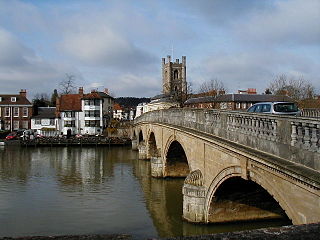
Henley Bridge is a road bridge built in 1786 at Henley-on-Thames over the River Thames, between Oxfordshire and Berkshire. The bridge has five elliptical stone arches, and links Hart Street in Henley with White Hill leading up a steep hill to Remenham Hill. It crosses the Thames on the reach between Hambleden Lock and Marsh Lock, carrying the Thames Path across the river. It is a Grade I listed building.

Sandford-on-Thames, also referred to as simply Sandford, is a village and Parish Council beside the River Thames in Oxfordshire just south of Oxford. The village is just west of the A4074 road between Oxford and Henley.

Osney or Osney Island is a riverside community in the west of the city of Oxford, England. In modern times the name is applied to a community also known as Osney Town astride Botley Road, just west of the city's main railway station, on an island surrounded by the River Thames, Osney Ditch and another backwater connecting the Thames to Osney Ditch.

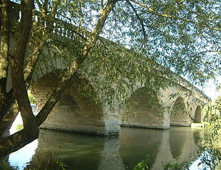
Clifton Hampden Bridge is a road bridge crossing the River Thames in Clifton Hampden, Oxfordshire, England, situated on the reach below Clifton Lock. Originally it joined Oxfordshire on the north bank with Berkshire on the south but in 1974 the area on the south bank was transferred from Berkshire to Oxfordshire. It is a Grade II* listed building.

Donnington Bridge is a modern road bridge over the River Thames, in the south of the city of Oxford, England. At this point the river is commonly called the Isis. The bridge carries the B4495 road from Abingdon Road to Iffley Road. It crosses the river on the reach between Iffley Lock and Osney Lock.
The Oxford Ring Road circles the city of Oxford, England. It is a dual carriageway ring road for most of its length apart from a short section between Woodstock Road and Banbury Road in the north of the city. The severe restrictions on traffic in Oxford city centre mean that it is the only practical way for long-distance traffic to get past Oxford, especially as there are few road bridges over the rivers Isis and Cherwell. Five Park and Rides are close to the ring road.
Swinford Toll Bridge is a privately owned toll bridge across the Thames in Oxfordshire, England. It crosses the river just above Eynsham Lock, between the village of Eynsham on the north-west bank and the hamlet of Swinford on the south-east bank. It carries the B4044 between Oxford and Eynsham, which was the A40 road until the north Oxford bypass was completed in 1936.

Newbridge is a 13th-century bridge carrying the Abingdon–Witney road over the River Thames in Oxfordshire, England, close to the Thames' confluence with the River Windrush. It is one of the two oldest surviving bridges on the Thames, part Grade I and part Grade II*-listed. The bridge is in a rural setting, with a public house at either end: the Maybush Inn on the south bank and the Rose Revived on the other. The bridge consists of two spans. The northern span crosses the river and the southern span, south of the Maybush, is dry underneath except when the river floods.

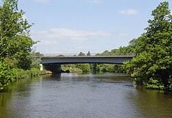
The A34 Road Bridge is a modern road bridge carrying the Oxford ring road at Oxford, England, across the River Thames. It crosses the Thames just upstream of Godstow Lock near Wolvercote on the reach to King's Lock. The bridge was built in 1961.
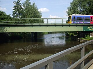
Osney Rail Bridge is a railway bridge over the River Thames at Oxford in England. It carries the Cherwell Valley Line between Didcot and Oxford across the river on the reach between Iffley Lock and Osney Lock.

Castle Mill Stream is a backwater of the River Thames in the west of Oxford, England. It is 5.5 km long.
The Swift Ditch is a 2 km (1.2 mi) long artificial channel that formed a short-cut for river traffic to and from Oxford, across a meander of the River Thames in England. It was formerly the primary navigation channel. With the main river, it creates Andersey Island on the left bank of the Thames opposite Abingdon-on-Thames. Within a poem published in 1632, the Water Poet John Taylor wrote:
At Abingdon the shoals are worse and worse
That Swift Ditch seems to be the better course

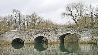
Culham Bridge is a medieval bridge crossing a present backwater of the River Thames in England at Culham, Oxfordshire, near the town of Abingdon. The bridge crosses Swift Ditch which was at one time the main navigation channel of the River Thames until Abingdon Lock was built in 1790. The bridge formerly carried the A415 road from Abingdon to Dorchester, Oxfordshire, but was superseded in 1928 by a modern road bridge.

Sheepwash Channel connects the River Thames to the west and the Castle Mill Stream next to the Oxford Canal to the east, in west Oxford, England. To the north are Cripley Meadow and Fiddler's Island. To the south are Osney Island and the Botley Road.