
Downing Street is a street in Westminster in London that houses the official residences and offices of the Prime Minister of the United Kingdom and the Chancellor of the Exchequer. Situated off Whitehall, it is 200 metres (660 ft) long, and a few minutes' walk from the Houses of Parliament. Downing Street was built in the 1680s by Sir George Downing.

Abingdon is a town in Washington County, Virginia, United States, 133 miles (214 km) southwest of Roanoke. The population was 8,376 at the 2020 census. It is the county seat of Washington County. The town encompasses several historically significant sites and features a fine arts and crafts scene centered on the galleries and museums along Main Street.

Abingdon-on-Thames, commonly known as Abingdon, is a historic market town and civil parish in the ceremonial county of Oxfordshire, England, on the River Thames. Historically the county town of Berkshire, Abingdon has been administered since 1974 by the Vale of White Horse district within Oxfordshire. The area was occupied from the early to middle Iron Age and the remains of a late Iron Age and Roman defensive enclosure lies below the town centre. Abingdon Abbey was founded around 676, giving its name to the emerging town. In the 13th and 14th centuries, Abingdon was an agricultural centre with an extensive trade in wool, alongside weaving and the manufacture of clothing. Charters for the holding of markets and fairs were granted by various monarchs, from Edward I to George II.
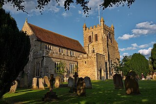
Wye is a village and former civil parish, now in the parish of Wye with Hinxhill, in the Ashford district, in Kent, England, 5 miles (8.0 km) from Ashford and 12 miles (19 km) from Canterbury. It is the main settlement in the parish of Wye with Hinxhill. Hop varieties including Wye Challenger were bred at Wye College and named for the village.

Stroud is a market town and civil parish in Gloucestershire, England. It is the main town in Stroud District. The town's population was 13,500 in 2021.
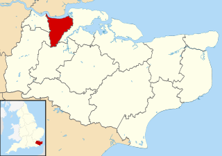
Gravesham is a local government district with borough status in north-west Kent, England. The council is based in its largest town of Gravesend. The borough is indirectly named after Gravesend, using the form of the town's name as it appeared in the Domesday Book of 1086. The district also contains Northfleet and a number of villages and surrounding rural areas.

Llantwit Major is a town and community in Wales on the Bristol Channel coast. It is one of four towns in the Vale of Glamorgan, with the third largest population after Barry and Penarth, and ahead of Cowbridge. It is 4+1⁄2 miles (7.2 km) from Cowbridge, 9 miles (14 km) from Bridgend, 10 miles (16 km) from Barry, and 15 miles (24 km) from Cardiff. It had a population of 9,530 in 2021.

Parliament Square is a square at the northwest end of the Palace of Westminster in the City of Westminster in central London, England. Laid out in the 19th century, it features a large open green area in the centre with trees to its west, and it contains twelve statues of statesmen and other notable individuals.
Roath is a district and community to the north-east of the city centre of Cardiff, capital of Wales. The area is mostly covered by the Plasnewydd electoral ward, and stretches from Adamsdown in the south to Roath Park in the north.
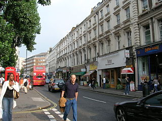
Westbourne Grove is a retail road running across Notting Hill, an area of west London. Its western end is in the Royal Borough of Kensington and Chelsea and its eastern end is in the City of Westminster; it runs from Kensington Park Road in the west to Queensway in the east, crossing over Portobello Road. It contains a mixture of independent and chain retailers, and has been termed both "fashionable" and "up-and-coming".

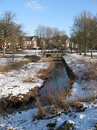
Richmond Green is a recreation area near the centre of Richmond, a town of about 20,000 inhabitants situated in south-west London. Owned by the Crown Estate, it is leased to the London Borough of Richmond upon Thames. The Green, which has been described as "one of the most beautiful urban greens surviving anywhere in England", is roughly square in shape and its open grassland, framed with broadleaf trees, extends to roughly twelve acres. On the north-east side there is also a smaller open space called Little Green. Richmond Green and Little Green are overlooked by a mixture of period townhouses, historic buildings and municipal and commercial establishments including the Richmond Lending Library and Richmond Theatre.

Abingdon Abbey was a Benedictine monastery in Abingdon-on-Thames in the modern county of Oxfordshire in the United Kingdom. Situated near to the River Thames, it was founded in c.675 AD and was dedicated to Mary, mother of Jesus. It was disestablished in 1538 during the dissolution of the monasteries. A few physical remnants of the Abbey buildings survive within Abingdon-on-Thames.

Gloucester Road is a street in the Royal Borough of Kensington and Chelsea, London. It runs north–south between Kensington Gardens and Old Brompton Road.
Park Place is a historic Grade II Listed country house and gardens in the civil parish of Remenham in Berkshire, England, set in large grounds above the River Thames near Henley, Oxfordshire.

Seacourt is a deserted medieval village near the City of Oxford. The site is now mostly beneath the Oxford Western By-pass, about 0.3 miles (0.48 km) south of the Seacourt / Hinksey Stream crossing.

Redcliffe Gardens is a primary road, the A3220 located in the Chelsea area of southwest central London, England. It was a development dated from 1864 to 1878.

St Mary Abbots is a church located on Kensington High Street and the corner of Kensington Church Street in London W8.

Lower Grosvenor Street was a street in London, England, later renamed Grosvenor Street. It was at the south-eastern corner of Grosvenor Square, extending eastward towards Bond Street. Count de Melfort, in his Impressions of England, described the street as consisting of "a great number of excellent houses, the majority of which are inhabited by titled persons and affluent families".

The Thames Ditton Foundry was a foundry in Thames Ditton, Surrey, which operated from 1874 to 1939 and which under various owners produced numerous major statues and monuments as one of the United Kingdom's leading firms of bronze founders.

Scarsdale Villas is a street in Kensington, London, that runs roughly west to east from Earls Court Road to Marloes Road, with crossroads at Abingdon Road and Allen Street en route. Houses were built there from 1850 to 1864.

