
The country of Brazil occupies roughly half of South America, bordering the Atlantic Ocean. Brazil covers a total area of 8,514,215 km2 (3,287,357 sq mi) which includes 8,456,510 km2 (3,265,080 sq mi) of land and 55,455 km2 (21,411 sq mi) of water. The highest point in Brazil is Pico da Neblina at 2,994 m (9,823 ft). Brazil is bordered by the countries of Argentina, Bolivia, Colombia, Guyana, Paraguay, Peru, Suriname, Uruguay, Venezuela, and France.

Rio de Janeiro, or simply Rio, is the capital of the state of the same name, Brazil's third most populous state, and the second most populous city in Brazil, after São Paulo. Listed by the GaWC as a beta global city, Rio de Janeiro is the sixth most populous city in the Americas. Part of the city has been designated as a World Heritage Site, named "Rio de Janeiro: Carioca Landscapes between the Mountain and the Sea", on 1 July 2012 as a Cultural Landscape.

Rio de Janeiro is one of the 27 federative units of Brazil. It has the second largest economy of Brazil, with the largest being that of the state of São Paulo. The state, which has 8.2% of the Brazilian population, is responsible for 9.2% of the Brazilian GDP.

Niterói is a municipality of the state of Rio de Janeiro in the southeast region of Brazil. It lies across Guanabara Bay facing the city of Rio de Janeiro and forms part of the Rio de Janeiro Metropolitan Area. It was the state capital, as marked by its golden mural crown, from 1834 to 1894 and again from 1903 to 1975. It has an estimated population of 515,317 inhabitants (2020) and an area of 129.375 km2 (49.952 sq mi), making it the fifth most populous city in the state. It has the highest Human Development Index of the state and the seventh highest among Brazil's municipalities in 2010. Individually, it is the second municipality with the highest average monthly household income per capita in Brazil and appears in 13th place among the municipalities of the country according to social indicators related to education. The city has the nicknames of Nikiti, Nicki City and the Smile City (Cidade Sorriso).
Carioca is a demonym used to refer to anything related to the City of Rio de Janeiro, in Brazil. The original meaning of the term is controversial, maybe from Tupi language "kari' oka", meaning "white house" as the whitewashed stone houses of European settlers or even the colonists themselves, by merging "kara'iwa" and "oka" (house). Currently, the more accepted origin in academia is the meaning derived from "kariîó oka", which comes from the indigenous tupi "house of carijó", which was Guaraní, a native tribe of Rio de Janeiro who lived in the vicinity of the Carioca River, between the neighborhoods of Glória and Flamengo.

Nova Friburgo is a municipality in the state of Rio de Janeiro in southeastern Brazil. It is located in the mountainous region, in the Center Mesoregion of the state, 136 km (85 mi) from its capital Rio de Janeiro. The town is 846 m (2,776 ft) above sea level. Its population was 191,158 (2020) and its area is 933 km2.

Duque de Caxias is a city on Guanabara Bay and part of Rio de Janeiro metropolitan area, southeastern Brazil.
Rio Grande is a river flowing to the Gulf of Mexico, forming a part of the Mexican-United States border.

Guanabara Bay is an oceanic bay located in Southeast Brazil in the state of Rio de Janeiro. On its western shore lie the cities of Rio de Janeiro and Duque de Caxias, and on its eastern shore the cities of Niterói and São Gonçalo. Four other municipalities surround the bay's shores. Guanabara Bay is the second largest bay in area in Brazil, at 412 square kilometres (159 sq mi), with a perimeter of 143 kilometres (89 mi).
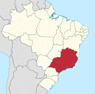
The Southeast Region of Brazil is composed of the states of Espírito Santo, Minas Gerais, Rio de Janeiro and São Paulo. It is the richest region of the country, responsible for approximately 60% of the Brazilian GDP, as São Paulo, Rio de Janeiro, and Minas Gerais are the three richest states of Brazil, the top three Brazilian states in terms of GDP. The Southeast of Brazil also has the highest GDP per capita among all Brazilian regions.

Nova Iguaçu is a municipality in Rio de Janeiro state in Brazil.

Barra da Tijuca is an upper-class neighborhood or bairro in the West Zone of Rio de Janeiro, Brazil, located in the western portion of the city on the Atlantic Ocean. Barra is well known for its beaches, its many lakes and rivers, and its lifestyle. This neighbourhood represents 4.7% of the city population and 13% of the total area of Rio de Janeiro.

Barreiras is a city located in the west of the state of Bahia, Brazil. It is the most important urban, political, technological and economic center of the western region of the state. Its economy is based on livestock raising and agriculture. In recent years it has experienced an economic boom and is one of the fastest-growing cities in the state of Bahia if not in Brazil.

The Rodovia Presidente Dutra,, colloquially known as Via Dutra is a federal highway which runs through the eastern part of the state of São Paulo and southwestern region of the state of Rio de Janeiro. It is the part of the route BR-116 connecting the city of São Paulo to the city of Rio de Janeiro.

Belford Roxo is a city in the state of Rio de Janeiro, Brazil. It is a part of the metropolitan region of the city of Rio de Janeiro and was created in 1990. Its population was 513,118 in 2020 and its area is 79 km². Belford Roxo is one of the less prosperous cities in the state, due to its low GDP and relatively large population. Its climate is tropical with an average temperature of 18 °C (63 °F). Bayer and Lubrizol are the biggest companies in the municipality. It was named after Engineer Raimundo Teixeira Belfort Roxo. While serving as General Construction and Building Inspector for the city of Rio de Janeiro, Belfort Roxo, together with fellow engineer Paulo de Frontin, solved the water shortage problems of the area during the summer of 1889.

The coastline of Brazil measures 7,491 km, which makes it the 16th longest national coastline of the world. All the coast lies adjacent to the Atlantic Ocean.
Acari is a group of arachnids containing ticks and mites.
Acari River may refer to several rivers in Brazil:

The Maracanã River of Rio de Janeiro, which means parrot-like in Tupi–Guarani, is a river located in Rio de Janeiro state in southeastern Brazil.
The following outline is provided as an overview of and topical guide to Rio de Janeiro:
