Achhua

Last updated

Achhua
Village
Achhua.jpg
India Bihar location map.svg
Red pog.svg
Achhua
Location in Bihar, India
India location map.svg
Red pog.svg
Achhua
Achhua (India)
Coordinates: 25°21′03″N84°49′04″E / 25.350852°N 84.817758°E / 25.350852; 84.817758 Coordinates: 25°21′03″N84°49′04″E / 25.350852°N 84.817758°E / 25.350852; 84.817758
CountryFlag of India.svg  India
State Bihar
District Patna
Population
 (2001)
  Total2,595
Languages
  Official Magahi, Hindi
Time zone UTC+5:30 (IST)
PIN
801110
Telephone code06135
ISO 3166 code IN-BR
Website patna.nic.in

Achhua is a village and Gram Panchayat in Patna district in the Indian state of Bihar. It comes under Dulhin Bazar Police Station and Paliganj Vidhan Sabha constituency. Achhua is known for PNK College which provides higher education in this area.

Patna district District of Bihar in India

Patna district is one of the thirty-eight districts of Bihar state in eastern India. Patna, the capital of Bihar state is the district headquarters. Patna district is a part of Patna division.

India Country in South Asia

India, also known as the Republic of India, is a country in South Asia. It is the seventh-largest country by area, the second-most populous country, and the most populous democracy in the world. Bounded by the Indian Ocean on the south, the Arabian Sea on the southwest, and the Bay of Bengal on the southeast, it shares land borders with Pakistan to the west; China, Nepal, and Bhutan to the northeast; and Bangladesh and Myanmar to the east. In the Indian Ocean, India is in the vicinity of Sri Lanka and the Maldives; its Andaman and Nicobar Islands share a maritime border with Thailand and Indonesia.

Bihar State in Eastern India

Bihar is a state in eastern India. It is the thirteenth-largest Indian state, with an area of 94,163 km2 (36,357 sq mi). The third-largest state by population, it is contiguous with Uttar Pradesh to its west, Nepal to the north, the northern part of West Bengal to the east, with Jharkhand to the south. The Bihar plain is split by the river Ganges, which flows from west to east. Three main regions converge in the state: Magadh, Mithila, and Bhojpur.

Contents

Geography

Achhua is located at 25°21′03″N84°49′04″E / 25.350852°N 84.817758°E / 25.350852; 84.817758 .

Achhua gram panchayat is composed of the following villages:

  1. Achhua,
  2. Rakasia,
  3. Alipur

Transport

Achhua is on SH 2. The State capital, Patna is 45 km to the north.

Education

  1. Primary School, Achhua: This is located at center of this village, provides primary education by Government of Bihar.
  2. Paras Nath Kushwaha College, Achhua: This is located on the Paliganj - Dulhin Bazaar SH 2 Road. A Degree College under Magadh University provides higher education in this area.

The literacy rate is 62.74% . The female literacy rate is 49.37% . The male literacy rate is 75.63%.

Economy

Agriculture is major source of economy. Paddy, Wheat, Pulse & Vegetables are the major agricultural production. Main sources of irrigation are monsoon and Canal which originate from Sone River.

Canal Man-made channel for water

Canals, or navigations, are human-made channels, or artificial waterways, for water conveyance, or to service water transport vehicles.

Related Research Articles

Gopalganj district, India District of Bihar in India

Gopalganj is one of the administrative districts in the Indian state of Bihar. The district headquarters is the town of Gopalganj, and the district is part of Saran Division. Major languages spoken are Bhojpuri, and Hindi.

Warisaliganj Town in Bihar, India

Warisaliganj is a Town and a Nagar Panchayat in Nawada district, in the Indian state of Bihar.

Islampur, Nalanda City in Bihar, India

Islampur is a city and Notified area in Nalanda district in the Indian state of Bihar.

Joypur, Purulia Community development block in West Bengal, India

Joypur is a community development block that forms an administrative division in Purulia Sadar West subdivision of Purulia district in the Indian state of West Bengal.

Polba Dadpur Community development block in West Bengal, India

Polba Dadpur is a community development block that forms an administrative division in Chinsurah subdivision of Hooghly district in the Indian state of West Bengal.

Obra, Bihar Town in Bihar, India

Obra is a small town 15 km away from the district headquarters on NH-98 (Garwa-Patna). Obra is also the headquarters of Obra block, under Daudnagar sub-division and a block of 144 villages having population of 220,000. In Obra block there are 20 panchayats each averaging 6 villages. Block stretched in north, east and south and demarcated by Daudnagar, Rafiganj, Aurangabad blocks and in west it is Rohtas district. Mahatma Gandhi and Bihar Vibhuti Dr. Anugraha Narain Sinha came to Obra during national independence movement.

Islampur, Uttar Dinajpur (community development block) Community development block in West Bengal, India

Islampur is a community development block that forms an administrative division in Islampur subdivision of Uttar Dinajpur district in the Indian state of West Bengal.

Barabazar (community development block) Community development block in West Bengal, India

Barabazar is a community development block that forms an administrative division in Purulia Sadar West subdivision of Purulia district in the Indian state of West Bengal.

Pakri Barawan Town in Bihar, India

Pakri Barawan is a town in the Nawada District of the Indian state of Bihar.

Ismailpur Village in Bihar, India

Ismailpur (Harauli) is a village in Vaishali district of Bihar state in India.

Bagmusha Place in Bihar, India

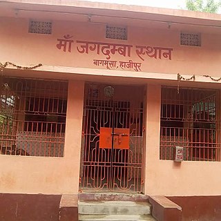
Bagmusha is a village of Hajipur Block and Tirhut Division of Bihar.Bagmusha is very nearest of Hajipur junction and NH 19.

Simaria Block Community development block in Jharkhand, India

Simaria is a community development block that forms an administrative division in Simaria subdivision of Chatra district, Jharkhand state, India.

Chatra (community development block) Community development block in Jharkhand, India

Chatra is a community development block that forms an administrative division in Chatra district in the Indian state of Jharkhand.

Shaligram Ramnarayanpur (community development block) Community development block in Jharkhand, India

Shaligram Ramnarayanpur (Hunterganj) is a community development block that forms an administrative division in Chatra subdivision of Chatra district in the Indian state of Jharkhand.

Loma (Jandaha) Village in India in Bihar

Loma is a Village in Jandaha Block of Vaishali district located 50 km from the Capital City of Bihar,(Patna) on the bank of Holy river Ganga. Village is best known for a Higher Secondary CBSE School named Best Model Public School founded in 2007 AD by Dr. Ajay Kumar.

Amhara, Bihar village in India

Amhara is a town and a Gram Panchayat in Bihta block of Patna district in the state of Bihar, India. Amhara lies in east of the Sone river and south of Bihta. The village is well connected to major cities with state highways.

Subhanpur village is located in Kashi Chak Tehsil of Nawada district in Bihar, India. It is situated 6 km away from sub-district headquarter Kashi Chak and 40 km away from the district headquarter Nawada. As per 2009 stats, Subhanpur village is itself a gram panchayat. According to 2011 census information the location code or village code of Subhanpur village is 257666.

Mokar Village in Bihar, India

Mokar is a Village located in Sasaram tehsil of Rohtas district in Bihar, India. It is situated 5 km away from Sasaram, which is both district & sub-district headquarter of Mokar village. As per 2009 stats, Mokar village is also a gram panchayat.

Ekara is a small village in Hajipur Tehsil/Block in Vaishali District in Indian state of Bihar, India. It comes under Ekara Panchayat. It belongs to Tirhut Division. It is located 9 km towards North from District headquarters Hajipur. As per 2009 stats, Thathan Buzurg is the gram panchayat of Ekara village. And 23 km from State capital Patna. Sonpur, Hajipur, Lalganj are the nearby Cities to Ekara. This Place is in the border of the Vaishali District and Saran District. Saran District Sonpur is west towards this place. Also it is in the Border of other district Patna.

References

Review Status