Ackertklippe

Last updated
View from the Konigsburg: right, behind the trees, the Ackertklippe Koenigshuette1.jpg
View from the Königsburg: right, behind the trees, the Ackertklippe

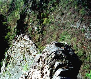
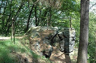
The Ackertklippe is a rock formation in Königshütte in the district of Harz in the Harz mountains of Germany. It is composed mainly of granite. A nearby road is named after the crag.

Granite A common type of intrusive, felsic, igneous rock with granular structure

Granite is a common type of felsic intrusive igneous rock that is granular and phaneritic in texture. Granites can be predominantly white, pink, or gray in color, depending on their mineralogy. The word "granite" comes from the Latin granum, a grain, in reference to the coarse-grained structure of such a holocrystalline rock. Strictly speaking, granite is an igneous rock with between 20% and 60% quartz by volume, and at least 35% of the total feldspar consisting of alkali feldspar, although commonly the term "granite" is used to refer to a wider range of coarse-grained igneous rocks containing quartz and feldspar.

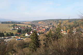
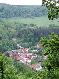
The crag can be climbed by a footpath. A refuge hut was built on the summit at the beginning of the 20th century. From the crag there is a comprehensive view of the village, the river Bode and the surrounding Harz mountains as far as the Wurmberg and the Brocken. The Ackertklippe rock formation also lends its name to the pub and boarding house Am Felsen, which is located below the crag on the Bode.

Bode (river) Sidestream of the river Saale

The Bode is a river in the German state of Saxony-Anhalt, a left tributary of the Saale. It rises in the Harz mountains and drains them in a northerly direction. After 169 kilometres (105 mi) it discharges into the Saale at Nienburg. The river is named after a legendary giant, the wild, rampaging, Bohemian, Prince Bodo, who, according to the Rosstrappe legend changed into a marauding dog that guarded the crown of Princess Brunhilde in the Kronensumpf in the present-day Bode Gorge. The gorge is the narrow section of the Bode valley between Treseburg and Thale.

Wurmberg Place in Baden-Württemberg, Germany

Wurmberg is a town in the district of Enz in Baden-Württemberg in Germany.

Brocken Harz mountain in Germany

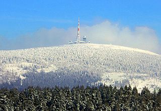
The Brocken, also sometimes referred to as the Blocksberg, is the highest peak of the Harz mountain range and also the highest peak of Northern Germany; it is located near Schierke in the German state of Saxony-Anhalt between the rivers Weser and Elbe. Although its elevation of 1,141 metres (3,743 ft) is below alpine dimensions, its microclimate resembles that of mountains of about 2,000 m (6,600 ft). The peak above the tree line tends to have a snow cover from September to May, and mists and fogs shroud it up to 300 days of the year. The mean annual temperature is only 2.9 °C (37.2 °F). It is the easternmost mountain in northern Germany; travelling east in a straight line, the next prominent elevation would be in the Ural Mountains in Russia.

The Ackertklippe hosts regular events such as Easter Fire (Osterfeuer) [1] and Walpurgis Night. [2]

Easter Fire

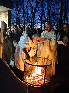
Easter fires are typically bonfires lit at Easter as part of liturgical and secular celebrations.

Walpurgis Night Germanic festival celebrating the start of summer

Walpurgis Night, an abbreviation of Saint Walpurgis Night, also known as Saint Walpurga's Eve, is the eve of the Christian feast day of Saint Walpurga, an 8th-century abbess in Francia, and is celebrated on the night of 30 April and the day of 1 May. This feast commemorates the canonization of Saint Walpurga and the movement of her relics to Eichstätt, both of which occurred on 1 May 870.

See also

List of rock formations in the Harz

Related Research Articles

Wurmberg Gondola Lift aerial tramway

The Wurmberg Gondola Lift is a monocable gondola lift with a length of 1.7 miles (2.7 km), built in 1963, leading from the Braunlage tourist resort within the Harz mountain range on the top of the 3,185 feet (971 m) high Wurmberg mountain.

Schierke Stadtteil of Wernigerode in Saxony-Anhalt, Germany

Schierke is a village and a former municipality in the Harz district, in the German state of Saxony-Anhalt. Since 1 July 2009, it is part of the town Wernigerode. Situated within the Harz mountain range in the valley of the Bode River, at the rim of the Harz National Park, it is mainly a tourist resort, especially for hiking and all kinds of winter sport.

Roßtrappe

The Roßtrappe is a 403-metre-high (1,322 ft) granite crag in the Harz mountains of central Germany.

Rübeland Ortsteil of Stadt Oberharz am Brocken

Rübeland is a village in the district of Harz in the German state of Saxony-Anhalt. Since 2004, it has been given the additional description of Höhlenort. The sub-districts of Rübeland are Susenburg, Kaltes Tal, Kreuztal and Neuwerk. Since 1 January 2010, it is part of the town Oberharz am Brocken and has 959 inhabitants.

Königshütte (Harz) human settlement in Germany

Königshütte is a German village in the district of Harz, in the state of Saxony-Anhalt. Since 1 January 2004 is a part of the municipality of Oberharz am Brocken.

Bode Gorge

The Bode Gorge is a 10 kilometres (6.2 mi) long ravine that forms part of the Bode valley between Treseburg and Thale in the Harz Mountains of central Germany. The German term, Bodetal, is also used in a wider sense to refer to the valleys of the Warme and Kalte Bode rivers that feed the River Bode.

Bäumlersklippe

The Bäumlersklippe is a crag and one of the so-called Harzklippen in the Harz National Park southwest of Ilsenburg. Whilst in former times it was a popular observation point, which the remains of an enclosing fence bear witness to, today beech and spruce trees have grown up around it.

Böser Kleef

The Böser Kleef is a rock formation, 440 metres above sea level, near the village of Altenbrak in the district of Harz in central Germany. It is made largely of granite.

Hoher Kleef

The Hoher Kleef is a rock formation in Rübeland in the district of Harz within the Harz mountains of Germany. It is mainly composed of granite.

Kahle Klippe

The Kahle Klippe is a rock formation in the High Harz in central Germany on the eastern slope of the Brocken above the valley of the Ecker.

The Taubenklippe is a rock formation in the Harz mountains in the German state of Saxony-Anhalt. It lies about halfway between Bad Harzburg and Ilsenburg at a height of 572 m above NN on the eastern slopes of the Ecker valley. From the crag there is a good view over Harz Foreland, the heights near Bad Harzburg and the highest mountain in the Har, the Brocken. The Taubenklippe may be reached from the Ecker valley on a footpath, some 6 km long, that starts in Ilsenburg.

Muxklippe

The Muxklippe is a granite rock formation in the Harz National Park in Germany.

Kästeklippen cliff in the Harz Mountains

The Kästeklippen, often shortened to Käste, is a rocky tor above the Oker valley in the Upper Harz mountains of central Germany. It lies at a height of 602 m above NN.

Feigenbaumklippe

The Feigenbaumklippe is a rock formation in the Oker valley in the Harz mountains of central Germany. They lie on the hiking trail from the Kästeklippen crags to Romkerhall Waterfall. These granite rocks, which show clear signs of "wool sack weathering" (Wollsackverwitterung) are a favourite destination for hikers and offer a good view of the valley towards the west. The observation point has safety railings.

Rabenklippe

The Rabenklippe is a granite rock formation in the Harz National Park. The name means "Raven Crag" and is very apt as ravens live in the vicinity.

Harschenhöllenklippe

The Harschenhöllenklippe is a rock formation in the Harz mountains in the German state of Saxony-Anhalt.

Teufelsmauer

The Teufelsmauer is a rock formation made of hard sandstones of the Upper Cretaceous in the northern part of the Harz Foreland in central Germany. This wall of rock runs from Blankenburg (Harz) via Weddersleben and Rieder to Ballenstedt. The most prominent individual rocks of the Teufelsmauer have their own names. The Teufelsmauer near Weddersleben is also called the Adlersklippen.

Schnarcherklippen

Schnarcherklippen is the name of a rock formation south of the village of Schierke in the High Harz mountains of Saxony-Anhalt in central Germany. The name translates roughly to "snoring crags" or "snoring rocks".

The Eckerloch is a forested mountain valley, 845 metres above sea level near the village of Schierke in the Harz Mountains of central Germany.

The Ahrensklint or Ahrentsklint in the Harz Mountains is a granite rock formation, 822.4 m above sea level (NN), on the Erdbeerkopf in Harz district in the German state of Saxony-Anhalt.

References

  1. Osterfeuer Archived April 14, 2009, at the Wayback Machine . at www.harzinfo.de. Retrieved on 6 Jun 2010.
  2. Walpurgis Elbe Börde Harz [ permanent dead link ] at www.fzp-wohin.de. Retrieved on 6 Jun 2010.

Coordinates: 51°44′38″N10°45′56″E / 51.74389°N 10.76556°E / 51.74389; 10.76556

Geographic coordinate system Coordinate system

A geographic coordinate system is a coordinate system that enables every location on Earth to be specified by a set of numbers, letters or symbols. The coordinates are often chosen such that one of the numbers represents a vertical position and two or three of the numbers represent a horizontal position; alternatively, a geographic position may be expressed in a combined three-dimensional Cartesian vector. A common choice of coordinates is latitude, longitude and elevation. To specify a location on a plane requires a map projection.