
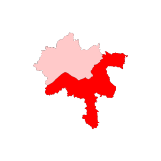
Oława County is a unit of territorial administration and local government (powiat) in Lower Silesian Voivodeship, south-western Poland. It was created on January 1, 1999 as a result of the Polish local government reforms passed in 1998. The county covers an area of 523.7 square kilometres (202.2 sq mi). Its administrative seat is the town of Oława, and its only other town is Jelcz-Laskowice.
Southernmost settlements are cities, towns, weather stations or permanent military bases which are farther south than latitude 45°S. They are closely related to the Southern Ocean or either the Roaring Forties or Furious Fifties. Antarctic bases are excluded due to not having a permanent population.

Bélabo is a town and commune in Cameroon, lying on the Yaoundé – N'Gaoundéré railway line. Near the town lies the Sanaga-Yong chimpanzee rescue centre.
Mong Ton also known historically as Möngtung and Maington, is a town and seat of Mong Ton Township in Mong Hsat District, Shan State in eastern Myanmar near the border with Thailand. Mong is equivalent to [Township or land]."Ton"is equivalent to [Royal City]. It is located in the Daen Lao Range, in the eastern part of the Shan State, east of the Salween River. Mong Ton lies on the National Highway 22 and connected to NarrkgMuu and Ponparkyin, is also connected to Mong Hsat by National Highway 49 which begins to the north-east of the town.

Busquístar is a small community located in the province of Granada, Spain. It is located in a region called The Alpujarras. According to the 2013 census (INE), the city has a population of 265 inhabitants.

Brañosera is a municipality located in the province of Palencia, Castile and León, Spain. According to the 2004 census (INE), the municipality had a population of 284 inhabitants. Brañosera has the oldest town hall in the entirety of Spain.
The Duroch Islands are a group of islands and rocks which extend over an area of about 3 nautical miles, centred about 1 nautical mile off Cape Legoupil on the north coast of Trinity Peninsula, Antarctica. The islands are close to Chile's Base General Bernardo O'Higgins Riquelme at Cape Legoupil.

Rábapaty is a village in Vas county, Hungary.
Kóspallag is a village in Pest county, Hungary.
Szigetújfalu is a village in Pest county, Hungary.

HMS Attack was an Acheron-class destroyer built in 1911, which served during the First World War and was sunk in 1917 in the Mediterranean by a German U-boat. She was the third ship of the name to serve in the Royal Navy.
Hacıqasımlı is a village and municipality in the Saatly Rayon of Azerbaijan. It has a population of 772.
Hopewell is a settlement in Clarendon Parish, Jamaica.

Akkimangala is a village in the southern state of Karnataka, India. It is located in the Chintamani taluk of Kolar district in Karnataka.

Soquel Canyon State Marine Conservation Area (SMCA) is an offshore marine protected area in Monterey Bay. Monterey Bay is on California’s central coast with the city of Monterey at its south end and the city of Santa Cruz at its north end. The SMCA covers 23.41 square miles (60.6 km2). Within the SMCA, fishing and taking of any living marine resources is prohibited except the commercial and recreational take of pelagic finfish.
Donje Lopiže is a village in the municipality of Sjenica, Serbia. According to the 2002 census, the village has a population of 123 people.
Simaria Assembly constituency is an assembly constituency in the Indian state of Jharkhand. The seat was created ahead of the 1977 Bihar Legislative Assembly election, being carved out of the Hazaribagh seat. Simaria is located in the Chatra Lok Sabha constituency.

The Valapattanam River is a 110 km long river which flows through the Kannur district in North Kerala. It is the longest river in the Kannur district.
Kogali is a village in the southern state of Karnataka, India. This village is located in Hagaribommanahalli Tehsil of Bellary district in Karnataka, India. It is situated 22 km away from sub-district headquarter Hagari bommanahalli and 122 km away from district headquarter Bellary.

The Squalo-class submarines were a group of four submarines built for the Royal Italian Navy during the 1930s. They were built at the Cantieri Riuniti dell'Adriatico (CRDA) shipyard at Monfalcone, and designed by Curio Bernardis.


