
Acton is a town in Middlesex County, Massachusetts, United States, approximately 21 miles (34 km) west-northwest of Boston along Massachusetts Route 2 west of Concord and about ten miles (16 km) southwest of Lowell. The population was 24,021 in April 2020, according to the United States Census Bureau. It is bordered by Westford and Littleton to the north, Concord and Carlisle to the east, Stow, Maynard, and Sudbury to the south and Boxborough to the west. Acton became an incorporated town in 1735. The town employs the Open Town Meeting form of government with a town manager and an elected, five-member select board. Acton was named the 11th Best Place To Live among small towns in the country by Money Magazine in 2015, and the 16th best in 2009 and in 2011. The local high school, Acton-Boxborough Regional High School, was named a Blue Ribbon School by the U.S. Department of Education in 2009.


The Rockery, also known as the Memorial Cairn, is an unusual war memorial designed by the noted American landscaper Frederick Law Olmsted. It is located at the center of North Easton Center in Easton, Massachusetts, where it forms the focal point for two adjacent H. H. Richardson buildings with their own Olmsted landscapes.

Winchester is an unincorporated community in Douglas County, Oregon, United States. It is on the south bank of the North Umpqua River 4 miles (6.4 km) north of Roseburg on Interstate 5 and is included in the Roseburg North CDP for statistical purposes.
The city of Wrexham has two main city parks, these being Bellevue Park and Acton Park. On the outskirts of the city there is also open parkland on and surrounding the Erddig estate. There is also a city centre green.

The Nashoba Brook Stone Chamber is an underground stone structure in the woods of the Nashoba Brook Conservation Area of Acton, Massachusetts. Its more common name is the "potato cave", which comes from the traditional assumption that it was once used as a root cellar. Research and excavation from 2006 supports this assertion, finding evidence of construction from the 18th or 19th century for the purpose of storing food. Some argue that it may originally have been a pre-colonial native American ceremonial stone landscape structure. Local lore states that it also served as shelter for workers on the nearby railroad in the 19th century.
Waterford is a village located on and around St. Paul Street in North Smithfield, Rhode Island and Blackstone, Massachusetts. The Blackstone River and Branch River converge just south of the village.

Boston Regional Medical Center was a 187-bed hospital located in Stoneham, Massachusetts. Previously known as New England Sanitarium and Hospital and later New England Memorial Hospital, it was located within the Middlesex Fells Reservation along Woodland Road in Stoneham, Massachusetts, until it closed in February 1999 for financial reasons.

Hartwell and Richardson was a Boston, Massachusetts architectural firm established in 1881, by Henry Walker Hartwell (1833–1919) and William Cummings Richardson (1854–1935). The firm contributed significantly to the current building stock and architecture of the greater Boston area. Many of its buildings are listed on the National Register of Historic Places.
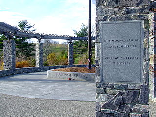
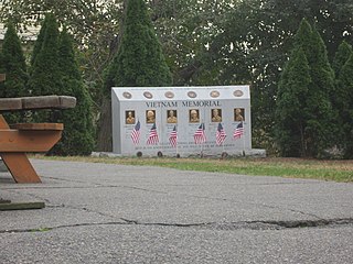
Green Hill Park is a large public park in Worcester, Massachusetts. The largest in the city, the park covers over 480 acres (1.9 km2). It is home to the Massachusetts Vietnam Veterans' Memorial, which honors veterans of the Vietnam War from Massachusetts. The Memorial was opened in June 2002. It is home to the Green Hill Park Shelter, an historic building on the National Register of Historic Places.
The Clapp Memorial Library is a public library in Belchertown, Massachusetts. Built in 1887 at the bequest of Belchertown native John Francis Clapp, the library is part of the Belchertown Center Historic District. Designed by New York architect H.F. Kilburn, it is built in the form of a Latin cross and features two large, stained glass windows as well as an eighty-foot-high tower in the center of the building. Constructed by the Bartlett Brothers of Whately, MA, the building features primarily local materials, including the brownstone from Longmeadow, MA, the brick trim from Holyoke, MA, and the stained glass windows, made from sand and silica from Western Massachusetts. The first librarian was Lydia A. Barton, who served from 1887 until her death in 1911. The building is not owned or maintained by the town, but rather by the Trustees of the Library.
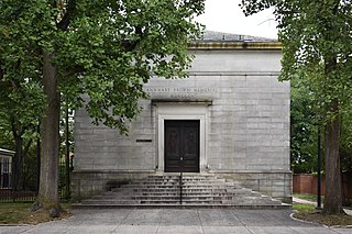
Annmary Brown Memorial is an art museum, library and mausoleum at Brown University. It is located at 21 Brown Street in Providence, Rhode Island. It is one of six libraries comprising the University Library system. Before merging with the university in 1948, the museum was founded as an independent collection by General Rush Hawkins and his wife, Annmary Brown (1837-1903). The Hawkinses are interred in a crypt at the building. The building was constructed in 1903 by architect Norman Isham. Today, the museum features a wide array of art from around the world.
The Bijou Theatre (1882–1943) in Boston, Massachusetts, occupied the second floor of 545 Washington Street near today's Theatre District. Architect George Wetherell designed the space, described by a contemporary reviewer as "dainty." Proprietors included Edward Hastings, George Tyler, and B.F. Keith. Around the 1900s, it featured a "staircase of heavy glass under which flowed an illuminated waterfall." The Bijou "closed 31 December 1943 and was razed in 1951." The building's facade still exists. It is currently a pending Boston Landmark by the Boston Landmarks Commission.
Boston State Hospital is a historic mental hospital located in Mattapan and Dorchester, Massachusetts. The court case Rogers v. Okin, which increases patient consent rights, was filed by a class action lawsuit against the hospital. The hospital was closed in 1979, and has been completely demolished and the site is in the process of being redeveloped.

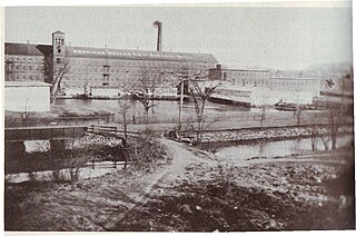
The Cambridge Assembly was a Ford Motor Company factory in Cambridge, Massachusetts which opened in 1913. The factory had the first vertically-integrated assembly line in the world. It was replaced in 1926 by the Somerville Assembly. The plant was later reused by Polaroid Corporation, and is now owned by the Massachusetts Institute of Technology.

The World War II Memorial by John Francis Paramino is installed in Boston, Massachusetts, United States. It was completed during 1947–1949, copyrighted in 1948, and erected in 1949. The bronze and granite war memorial features an allegorical statue of winged female figure of Victory. Behind her is a wall with 27 bronze plaques listing the names of people who died in World War II. The work was surveyed as part of the Smithsonian Institution's "Save Outdoor Sculpture!" program in 1993.
The Charlestown Vietnam Veterans Memorial is a war memorial commemorating six local men who died who during the Vietnam War, installed outside Veterans Memorial Hall in Charlestown, Boston, in the U.S. state of Massachusetts. The memorial was dedicated in April 2009.
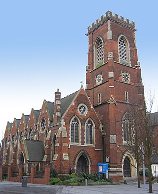
St Mary's Church is a Church of England parish church in Acton in the London Borough of Ealing. The present church, in red brick with stone dressings in a decorated style, was designed by Horace Francis and constructed 1865–1867. The church was listed Grade II in 1981.


