
The City and Borough of Juneau, commonly known as Juneau, is the capital city of Alaska. Located in the Gastineau Channel and the Alaskan panhandle, it is a unified municipality and the second largest city in the United States by area. Juneau was named the capital of Alaska in 1906, when the government of what was then the District of Alaska was moved from Sitka as dictated by the U.S. Congress in 1900. The municipality unified on July 1, 1970, when the city of Juneau merged with the city of Douglas and the surrounding Greater Juneau Borough to form the current municipality, which is larger by area than both Rhode Island and Delaware.

Lake and Peninsula Borough is a borough in the state of Alaska. As of the 2010 census, the population was 1,631. The borough seat of King Salmon is located in neighboring Bristol Bay Borough, although is not the seat of that borough. The most populous community in the borough is the city of Newhalen. With an average of 0.0296 inhabitants/km2, the Lake and Peninsula Borough is the second least densely populated organized county-equivalent in the United States; only the unorganized Yukon-Koyukuk Census Area has a lower density.

Hoonah–Angoon Census Area is a census area located in the U.S. state of Alaska. As of the 2010 census, the population was 2,150. It is part of the unorganized borough and therefore has no borough seat. Its largest community is the city of Hoonah.

Douglas Island is a tidal island in the U.S. state of Alaska. It is part of the city and borough of Juneau, just west of downtown Juneau and east of Admiralty Island. It is separated from mainland Juneau by the Gastineau Channel, and contains the communities of Douglas and West Juneau.

The Mendenhall Valley is the drainage area of the Mendenhall River in the U.S. state of Alaska. The valley contains a series of neighborhoods, comprising the largest populated place within the corporate limits of the City and Borough of Juneau, Alaska's capital.
Douglas is a community on Douglas Island in southeastern Alaska, directly across the Gastineau Channel from downtown Juneau.
Yaaḵoosgé Daakahídi Alternative High School is a high school of the Juneau School District in the City and Borough of Juneau, Alaska, United States. The school is an opportunity for students over the age of 16 to have a less mainstream high school experience than that offered by Juneau-Douglas High School or Thunder Mountain High School. In recent years, the school has hosted nearly 100 students ages 16 and up. The school serves students at risk of dropping out, about half of whom are from racial and ethnic minorities. The school graduates about 40 students a year.
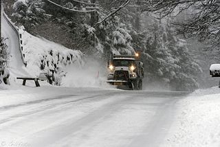
Out the road is a colloquial term for a region of the City and Borough of Juneau, capital of the U.S. state of Alaska, extending from Auke Bay north to a point roughly 45 miles (72 km) from downtown Juneau to where "The Road" dead ends at Echo Cove, a natural harbor with a boat ramp, parking lot, and several camping areas. Juneau is accessible only by boat or plane. Out the road is by far the largest percentage of land area of Juneau, but very sparsely populated; in spring 1998, the Juneau Economic Development Council put its population at 1,348.
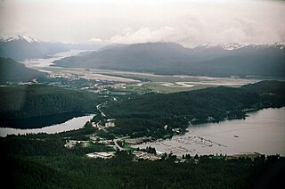
Auke Bay is an unincorporated community located in the city and borough of Juneau, Alaska, that contains Auke Bay Harbor, Auke Lake, the University of Alaska Southeast, an elementary school, a church, a post office, a bar, a coffee shop, a waffle house, a thrift shop, a Thai restaurant, and one convenience store. The view of the Mendenhall Glacier behind Auke Bay and Mount McGinnis towering over Auke Lake are some of the most popular photo opportunities in Juneau. The ferry terminal of the Alaska Marine Highway system is also located further out the road in Auke Bay at about 14 mile. The flamingo house on Auke Lake is a local attraction, known for its topical or weather-related formations of pink lawn flamingos. Whale watchings targeting curious humpbacks are available. Humpbacks in these areas are known to demonstrate special feeding methods, so-called "bubble-net feeding", and come very close to shores.
Douglas Harbor is a harbor off the coast of Douglas Island in Juneau, Alaska. The name was published by the United States Geological Survey in 1986 and entered into the Geographic Names Information System on January 1, 2001.
Lemon Creek is a neighborhood in Juneau, Alaska, United States. The name was entered into the Geographic Names Information System on January 1, 2000. It is 5 miles (8 km) northwest of downtown Juneau. It is the site of the Lemon Creek Correctional Center. The neighborhood is bisected by the namesake Lemon Creek, which provides runoff for local glaciers.
Lena Beach is a populated place in Juneau, Alaska, United States. The name was first published by the Bureau of the Census in 1940 and entered into the Geographic Names Information System on March 23, 2001. It is 14 miles (23 km) northwest of the city of Juneau.
Chapel by the Lake is a Presbyterian church in Auke Bay, Alaska. It was designed by Juneau-based architects Harold Foss and Linn A. Forrest. The construction lasted from 1954 to 1958.

The Capital Transit System is the public transportation agency that serves the city and burough of Juneau, Alaska. Owned by the municipality, it runs two seven-day routes and an additional one on weekdays.
Starr Hill is a populated place in Juneau, Alaska, United States. It is named for Frank Starr (1849-1898), a soldier from Maine who arrived shortly after the discovery of the Juneau gold fields in 1880, staked some claims but mainly found work in construction. Starr also staked land on the hill near the road leading to the Silver Bow Basin gold fields. The Hill saw significant development beginning in 1913 when Conrad Fries built six miners’ cabins on the 500 block of Kennedy Street, buildings which are now listed on the National Register of Historic Places. A few years later Juneau businessman Bernard (B.M.) Behrends built five smaller cabins on the 400 block of Kennedy. Starr Hill now includes several dozen private homes which overlook upper Juneau and the Alaska State Capitol, and a trailhead to the Mount Roberts Trail.

Tee Harbor refers to two adjacent populated places in the City and Borough of Juneau, Alaska. The area had a population of 32 in 1950. It is located 3 miles (4.8 km) northwest of Fairhaven and 17 miles (27 km) northwest of the main city of Juneau.
Elevenmile Creek is a river on Douglas Island in the City and Borough of Juneau (CBJ), Alaska, United States. Its origin is in hills to the southeast and it flows northwest to Fritz Cove, a part of Stephens Passage; it is 1.6 miles (2.6 km) southwest of Entrance Point and 8.6 miles (13.8 km) west of the city of Juneau.
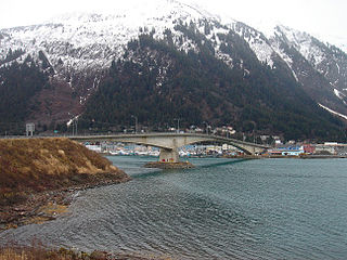
The Douglas Bridge is located in Juneau, Alaska. Spanning the Gastineau Channel, it connects Juneau's eastern, mainland side with the city's communities on Douglas Island to the west. The current span is the second bridge of the same name; the original, built in 1935, was demolished in 1981 following the completion of its replacement in 1980.

Bartlett Regional Hospital (BRH) is a hospital serving Juneau, Alaska, the capital city of Alaska and the largest city in Southeast Alaska. The hospital is owned by the City and Borough of Juneau. BRH is the only hospital in Juneau, and provides the only emergency department in the city. In addition, BRH operates the adjacent Rainforest Recovery Center, an inpatient and outpatient drug and alcohol treatment center.

