A gold rush or gold fever is a discovery of gold—sometimes accompanied by other precious metals and rare-earth minerals—that brings an onrush of miners seeking their fortune. Major gold rushes took place in the 19th century in Australia, Greece, New Zealand, Brazil, Chile, South Africa, the United States, and Canada while smaller gold rushes took place elsewhere.

Baja California Sur, officially Estado Libre y Soberano de Baja California Sur, is the least populated state and the 31st admitted state of the 32 federal entities which comprise the 31 States of Mexico. It is also the ninth-largest Mexican state in terms of area.

BHP Group Limited is an Australian multinational mining and metals public company headquartered in Melbourne, Australia.

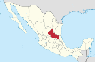
San Luis Potosí, officially the Free and Sovereign State of San Luis Potosí, is one of the 32 states which compose the Federal Entities of Mexico. It is divided in 58 municipalities and its capital city is San Luis Potosí (City).

Pachuca, formally known as Pachuca de Soto, is the capital and largest city of the east-central Mexican state of Hidalgo, located in the south-central part of the state. Pachuca de Soto is also the name of the municipality for which the city serves as municipal seat. Pachuca is located about 90 kilometres (56 mi) north of Mexico City via Mexican Federal Highway 85.

The Revillagigedo Islands or Revillagigedo Archipelago are a group of four volcanic islands in the Pacific Ocean, known for their unique ecosystem. They lie approximately 458 kilometres (285 mi) from Socorro Island south and southwest of Cabo San Lucas, the southern tip of the Baja California Peninsula, and 698 to 1,092 kilometres west of Manzanillo. Historically linked to the Mexican state of Colima, to which they were granted in 1861 to establish a penal colony, the islands are under Mexican federal property and jurisdiction.

ASARCO is a mining, smelting, and refining company based in Tucson, Arizona, which mines and processes primarily copper. The company has been a subsidiary of Grupo México since 1999.

A land claim is defined as "the pursuit of recognized territorial ownership by a group or individual". The phrase is usually only used with respect to disputed or unresolved land claims. Some types of land claims include aboriginal land claims, Antarctic land claims, and post-colonial land claims.

Orica Limited is an Australian-based multinational corporation that is one of the world's largest providers of commercial explosives and blasting systems to the mining, quarrying, oil and gas, and construction markets, a supplier of sodium cyanide for gold extraction, and a specialist provider of ground support services in mining and tunnelling.

Hashima Island, commonly called Gunkanjima, is a tiny abandoned island off Nagasaki, lying about 15 kilometres from the centre of the city. It is one of 505 uninhabited islands in Nagasaki Prefecture. The island's most notable features are its abandoned concrete buildings, undisturbed except by nature, and the surrounding seawall. While the island is a symbol of the rapid industrialization of Japan, it is also a reminder of Japanese war crimes as a site of forced labour prior to and during World War II.

New Almaden, known in Spanish as Nueva Almadén, is a historic community and former mercury mine in the Capitancillos Hills of San Jose, California, located at the southwestern point of Almaden Valley in South San Jose. New Almaden is divided into two parts: the mines and much of their immediate surroundings, including historic ghost town settlements in the Capintancillas, which together form the Almaden Quicksilver County Park, and the largely residential historic district surrounding the Casa Grande.
Grupo México is a Mexican conglomerate that operates through the following divisions: Mining, Transportation, Infrastructure and Fundacion Grupo Mexico.

The Sierra Gorda is an ecological region centered on the northern third of the Mexican state of Querétaro and extending into the neighboring states of Guanajuato, Hidalgo and San Luis Potosí. Within Querétaro, the ecosystem extends from the center of the state starting in parts of San Joaquín and Cadereyta de Montes municipalities and covering all of the municipalities of Peñamiller, Pinal de Amoles, Jalpan de Serra, Landa de Matamoros and Arroyo Seco, for a total of 250 km2 of territory. The area is extremely rugged with high steep mountains and deep canyons. As part of the Huasteca Karst, it also contains many formations due to erosion of limestone, especially pit caves known locally as sótanos. The area is valued for its very wide diversity of plant and animal life, which is due to the various microenvironments created by the ruggedness of the terrain and wide variation in rainfall. This is due to the mountains’ blocking of moisture coming in from the Gulf of Mexico, which generally makes the east side fairly moist and the west semiarid scrub brush. Most of the region is protected in two biosphere reserves, with the one centered in Querétaro established in 1997 and the one centered in Guanajuato established in 2007. The Sierra Gorda is considered to be the far west of the La Huasteca region culturally and it is home to the Franciscan Missions in the Sierra Gorda of Querétaro World Heritage Site. Sierra Gorda has become the first National Park in Mexico to join the EarthCheck Sustainable Destinations program.

The Cornish diaspora consists of Cornish people and their descendants who emigrated from Cornwall, United Kingdom. The diaspora is found within the United Kingdom, and in countries such as the United States, Canada, Mexico, Panama, Colombia, Peru, Chile, Argentina, Brazil, South Africa, Australia, New Zealand, and the Samoas.

The Cornwall and West Devon Mining Landscape is a World Heritage Site which includes select mining landscapes in Cornwall and West Devon in the south west of England. The site was added to the World Heritage List during the 30th Session of the UNESCO World Heritage Committee in Vilnius, July 2006. Following plans in 2011 to restart mining at South Crofty, and to build a supermarket at Hayle Harbour, the World Heritage Committee drafted a decision in 2014 to put the site on the List of World Heritage in Danger, but this was rejected at the 38th Committee Session at Doha, Qatar, in favour of a follow-up Reactive Monitoring Mission.

Silver mining is the extraction of silver by mining. Silver is a precious metal and holds high economic value. Because silver is often found in intimate combination with other metals, its extraction requires the use of complex technologies. In 2008, approximately 25,900 metric tons of silver were consumed worldwide, most of which came from mining. Silver mining has a variety of effects on the environment, humans, and animals.

The Treadwell gold mine was on the south side of Douglas Island, .5-mile (0.80 km) east of downtown Douglas and southeast of downtown Juneau, owned and operated by John Treadwell. Composed of four sub-sites, Treadwell was in its time the largest hard rock gold mine in the world, employing over 2,000 people. Between 1881 and 1922, over 3 million troy ounces of gold were extracted. Not much remains today except for a few crumbling buildings and a "glory hole". Although John Treadwell had twelve years of experience in both placer and lode mines, he was a carpenter and builder by trade who had come to Alaska prior to the Klondike Gold Rush.

The environmental history of Latin America has become the focus of a number of scholars, starting in the later years of the twentieth century. But historians earlier than that recognized that the environment played a major role in the region's history. Environmental history more generally has developed as a specialized, yet broad and diverse field. According to one assessment of the field, scholars have mainly been concerned with "three categories of research: colonialism, capitalism, and conservation" and the analysis focuses on narratives of environmental decline. There are several currents within the field. One examines humans within particular ecosystems; another concerns humans’ cultural relationship with nature; and environmental politics and policy. General topics that scholars examine are forestry and deforestation; rural landscapes, especially agro-export industries and ranching; conservation of the environment through protected zones, such as parks and preserves; water issues including irrigation, drought, flooding and its control through dams, urban water supply, use, and waste water. The field often classifies research by geographically, temporally, and thematically. Much of the environmental history of Latin America focuses on the nineteenth and twentieth centuries, but there is a growing body of research on the first three centuries (1500-1800) of European impact. As the field established itself as a more defined academic pursuit, the journal Environmental History was founded in 1996, as a joint venture of the Forest History Society and the American Society for Environmental History (ASEH). The Latin American and Caribbean Society for Environmental History (SOLCHA) formed in 2004. Standard reference works for Latin American now include a section on environmental history.


