Demographics
Based on figures from the Central Statistical Agency in 2005, this zone has an estimated total population of 88,784, of whom 45,529 are men and 43,255 are women; 1,741 or 2% of its population are urban dwellers. With an estimated area of 6,023.29 square kilometers, this zone has an estimated population density of 14.74 people per square kilometer. [3]
The 1994 national census reported a total population for this Zone of 68,224 in 9,688 households, of whom 34,807 were men and 33,417 women; 1,013 or 1.48% of the population were urban inhabitants. (This total also includes an estimate for 9 of the 19 kebeles in Akobo woreda, which were not counted; they were estimated to have 13,903 inhabitants, of whom 6,637 were men and 7,266 women.) The two largest ethnic groups of Zone 3 were the Nuer (98.38%), and the Anuak (1.56%); all other ethnic groups made up 0.06% of the population. Nuer was spoken as a first language by 98.47%, and 1.49% speak Anuak; the remaining 0.04% spoke all other primary languages reported. The majority of the inhabitants said they were Protestant, with 64.73% of the population reporting they embraced that belief, while 15.24% practiced traditional religions, 3.74% professed Ethiopian Orthodox Christianity, and 1.31% were Catholic. [4]

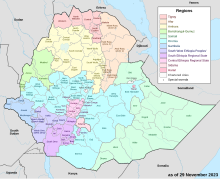
The Gambela Region (also spelled Gambella (Catching the male Leopard in Anywaa language); Amharic: ጋምቤላ), officially the Gambela Peoples' Region, is a regional state in western Ethiopia, bordering South Sudan. Previously known as Region 12, its capital is Gambela located in Anywaa zone. The Region is situated between the Baro and Akobo Rivers, with its western part including the Openo River. Covering an area of approximately 29,783 square kilometers, Gambela is one of Ethiopia's smaller regions and one of its least populous, with 525,000 inhabitants. It is home to a diverse population, including the Anuak the indigenous, Nuer, and other indigenous groups called Majang Komo and Opo. The region's economy is largely based on agriculture, with significant contributions from fishing and cross-border trade. The landscape is characterized by lowland plains, wetlands, and a tropical climate, making it distinct from the highland areas that dominate much of Ethiopia.

Gambela, also spelled Gambella, is a city and separate woreda in Ethiopia and the capital of the Gambela Region. Located in Anyuak Zone, at the confluence of the Baro River and its tributary the Jajjabe, the city has a latitude and longitude of 8°15′N34°35′E and an elevation of 526 meters. It is surrounded by Gambella Zuria.

Administrative Zone 1 was one of the three zones of the Ethiopian Region of Gambela. This zone was bordered on the south by Administrative Zone 2, on the west by Administrative Zone 3 and on the north and east by the Oromia Region. It was later added to Anuak Zone. Towns and cities in this zone included Itang and Gambela.

Administrative Zone 2 was one of the three zones of the Ethiopian Region of Gambela. This zone was bordered by South Sudan and the Southern Nations, Nationalities, and Peoples Region on the south, Administrative Zone 3 on the west, Administrative Zone 1 on the north, and the Godere special woreda on the east. It was added to Anuak Zone. Towns in this zone included Abobo and Fugnido.
Godere is a woreda in Gambela Region, Ethiopia. Part of the Mezhenger Zone, Godere is bordered on the south and east by the Southern Nations, Nationalities and Peoples Region (SNNPR), and on the west by Mengesh. The largest town in Godere is Meti.
Gog is a woreda in Gambela Region, Ethiopia. Part of the Anuak Zone, Gog is bordered on the south by Dimma, on the southwest by the Akobo River which separates it from South Sudan, on the west by Jor, and on the north by Abobo. The major town in Gog is Fugnido.
Jor is a woreda in Gambela Region, Ethiopia. Part of the Anuak Zone, Jor is bordered on the south by the Akobo River which separates it from South Sudan, on the west and north by the Nuer Zone, on the northeast by Abobo, and on the east by Gog; the Alooworro River defines part of its northern boundary. The administrative center of this County is Ongoogi.
Itang is a woreda in Gambela Region, Ethiopia. Because Itang is not part of any zone in the Gambela Region, it is considered a Special woreda, an administrative subdivision which is similar to an autonomous area. It is bordered on the south and southeast by the Anuak Zone, on the west by the Nuer Zone, on the northwest by South Sudan, and on the north by the Oromia Region; part of the southern boundary is defined by the Alwero River. The major town in Itang is Itang.
Gambela Zuria was a woreda in the Gambela Region of Ethiopia. Part of the Anuak Zone, Gambela Zuria is bordered on the south by Abobo, on the west by Itang special woreda, and on the north and east by the Oromia Region. Gambela, which is the capital of the Region, is surrounded by this woreda.
Akobo (Aköbä) is a woreda in Gambela Region, Ethiopia. It is named after the Akobo in Anyuak language language, which translates as, and the Akoba River which flows westwards then north into the Baro River, defining its border with South Sudan. Part of the Nuer Zone, Akobo is bordered on the south and west by South Sudan, on the north by Wanthoa or Wanthɔa̱r ,and on the east by the Anuak Zone. The westernmost point of this woreda is the westernmost point of Ethiopia. Towns in Akobo include Tergol.
'Jikaw (Ji̱ekɔ̱w) is a woreda in Gambela Region, Ethiopia. Part of the Nuer Zone, Jikaw is bordered on the south by the Anuak Zone, on the west by the Alwero River which separates it from Wanthoa, on the north by the Baro River which separates it from South Sudan, and on the east by Lare. Towns in Jikaw include Kuachthiang and Teluth.
Bure is one of the woredas in the Oromia Region of Ethiopia. Part of the Illubabor Zone, Bure is bordered on the south by Nono, on the southwest by the Gambela Region, on the west by the Kelem Welega Zone, on the northeast by Metu, and on the southeast by Ale; the Birbir River defines the west and north boundaries. Towns in Bure include Bure and Sibo. Huka Halu woreda was separated from Bure.
Anfillo is a woreda in Oromia Region, Ethiopia. Part of the Kelem Welega Zone, Anfillo is bordered on the southwest by the Gambela Region, on the north by Jimma Gidami, on the northeast by Yemalogi Welele, and on the east by Sayo. The major town in Anfillo is Mugi.
Jimma Rare is a woreda in Oromia Region, Ethiopia. It shares the name of one of the subgroups of the Oromo people, the Jimma Rare. Part of the Horo Gudru Welega Zone, Jimma Rare is bordered on the west by Jimma Horo, on the north by Guduru, on the east and south by the Guder River which separates it from the West Shewa Zone. The administrative center of the woreda is Wayu; other towns in Jimma Rare include Goben and Babal'a.
Dinsho is one of the districts in the Oromia Region of Ethiopia. It was part of former Sinanana Dinsho woreda what was separated for Dinsho and Sinana woredas and Robe Town. Part of the Bale Zone, Sinanana Dinsho was bordered on the south by the Mena River which separated it from Goba, on the west by Adaba, on the northwest by Agarfa, on the northeast by Gaserana Gololcha, on the east by Ginir, and on the southeast by Goro, Oromia. The administrative center of this woreda is Dinsho.
Dimma is a woreda in Gambela Region, Ethiopia. Part of the Anuak Zone, Dimma is bordered on the southeast by the Southern Nations, Nationalities and Peoples Region (SNNPR), on the southwest by the Akobo River which separates it from South Sudan, on the north by Gog, and on the northeast by the Mezhenger Zone. The major town in Dimma is Dimma.

Lare is one of the Districts of Ethiopia, or woredas, in the Gambela Region of Ethiopia. Part of the Nuer Zone, Lare is bordered on the south and east by the Anuak Zone, on the west by the Baro River which separates it from Jikaw, and on the north by the Jikaw River which separates it from South Sudan. Towns in Lare include Kuergeng.

Wanthoa [Wanthɔa̱r]is one of the woredas in the Gambela Region of Ethiopia. Part of the Nuer Zone, Wanthoa is bordered on the south by Akobo, on the west and north by South Sudan, on the east by Jikaw, and on the southeast by Anuak Zone; the Akobo River to the west and the Baro River on the north define Wanthoa's boundaries with South Sudan. Towns in this woreda include Matar.

The Mezhenger Zone or Majang Zone is a zone in Gambela Region of Ethiopia. It is named for one of the three largest indigenous groups in Gambela, the Majangir. This zone is bordered on the south and east by the Southern Nations, Nationalities and Peoples Region (SNNPR), on the west by the Anuak Zone, and on the north by the Oromia Region. Towns in this Zone include Meti.

The Nuer Zone Amharic Thok Naath, is a zone in the Gambela Region of Ethiopia. It was created from former Administrative Zone 3. The Nuer zone is located in western Gambella and is the westernmost zone of Ethiopia. The Zone is bordered by South Sudan, on the Northern Baro River, Western Piwbör, and Southwestern Pibor River, on the east by Itang Special Woreda, and on the South-East by Anuak Zone. The administration town Nyinenyang, contains five administrator woreda; Kuergeng Town, Kuach Thia̱ng Town, Nyinenyang Town, (Wanthɔa̱r)Matar Town, and (Aköbä)Tiergol Town. Nuer Zone is within the Ethiopian lowlands and is relatively flat at an elevation between 400–430 meters above sea level. The zone consists of grasslands, marshes and swamps with some forests. The economy is predominantly based on livestock. In 2006, there were no agricultural cooperatives, no documented roads, and little other Reference infrastructure. Both Jikawo and Akobo woredas are flooded during the rainy season, requiring the people to migrate to the highlands with their cattle until the waters recede; thus raising livestock is the primary source of income in this Zone.


