
The River Mellte is a river in south Wales. It is formed by the confluence of the Afon Llia and the Afon Dringarth. It then flows south through the village of Ystradfellte to Pontneddfechan where it joins with the Nedd Fechan to become the River Neath. The river derives its name from 'mellt' - the Welsh word for 'lightning' - after its tendency to rise and fall rapidly in response to heavy rainfall.

Blorenge, also called The Blorenge, is a prominent hill overlooking the valley of the River Usk near Abergavenny, Monmouthshire, southeast Wales. It is situated in the southeastern corner of the Brecon Beacons National Park. The summit plateau reaches a height of 561 metres (1,841 ft).

The Black Mountain is a mountain range in South, Mid and West Wales, straddling the administrative boundary between Carmarthenshire and Powys and forming the westernmost range of the Brecon Beacons National Park. Its highest point is Fan Brycheiniog at 802 metres or 2,631 ft. The Black Mountain also forms a part of the Fforest Fawr Geopark.

Bethlehem is a tiny farming village in the county of Carmarthenshire, Wales, lying in the Tywi Valley northeast of Llandeilo and southwest of Llangadog but on the opposite side of the river from the busy London to Haverfordwest road, the A40.

The Beacons Way is a waymarked long distance footpath in the Brecon Beacons National Park, Wales. It is a linear route which runs for 99 miles (159 km) east to west through the National Park, and passes many of the most important landmarks and mountain peaks in the mountain range. It also includes a few of the towns in the park as well as popular attractions such as Carreg Cennen Castle near Llandeilo at the western end of the path.

Cefn yr Ystrad is a mountain in the Brecon Beacons National Park in Wales. It is an outlier of the Central Beacons group.

Fan Fawr is a mountain in the Fforest Fawr section of the Brecon Beacons National Park, in Powys, Wales and over 734 m (2,408 ft) high.
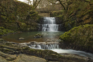
The Afon Pyrddin is a river forming a short section of the boundary between the counties of Brecknockshire and Glamorgan in Wales, United Kingdom. It also forms a part of the boundary of the Brecon Beacons National Park, and the boundary of the unitary authorities of Powys and Neath Port Talbot. The river and its waterfalls are one of the key attractions of the Fforest Fawr Geopark designated in 2005.
The Afon Llia is a short river in Powys, Wales, and which is wholly contained within the Brecon Beacons National Park.
The Afon Dringarth is a river in Powys, Wales and wholly contained within the Brecon Beacons National Park. Its headwater streams drain the eastern slopes of Fan Dringarth, the southern slopes of Craig Cerrig-gleisiad and the western slopes of Fan Fawr. The river flows south-southwest for about 6 km / 3.5 mi to its confluence with the Afon Llia one mile north of the village of Ystradfellte, continuing south as the Afon Mellte. The river may derive its name from the hill immediately to its west, Fan Dringarth.

The Afon Crai is a river in Powys, Wales rising in the Fforest Fawr section of the Brecon Beacons National Park and flowing north into the River Usk. The headwaters known as Blaen-crai flow north from Bwlch Bryn-rhudd, a col between the Crai valley and the upper Swansea Valley for 2 km into the Cray Reservoir. The river emerges from below the dam to flow a further 8 km through the dispersed settlement of Crai.

The Afon Senni is a river in Powys, Wales which rises in the Fforest Fawr section of the Brecon Beacons National Park and flows northwards for 11 kilometres (7 mi) to a confluence with the River Usk at Sennybridge.
Heol Senni is a hamlet in the valley of the Afon Senni just north of the Fforest Fawr section of the Brecon Beacons National Park. It lies within the community of Maescar in the county of Powys, Wales. The Welsh name means the 'road by Senni' and reflects its position near the crossing of the river by the minor road running from the A4067 to the A4215 road. This route was, and to some extent still is, an important link between Brecon and the upper Swansea Valley.
Fforest Fawr Geopark is a Geopark in the Brecon Beacons National Park, south Wales. It is the first designated Geopark in Wales having gained membership of both the European Geoparks Network and the UNESCO-assisted Global Network of National Geoparks in October 2005. The Geopark aims to promote and support sustainable tourism and other opportunities to improve the economy of the area whilst safeguarding the natural environment. Its aims largely coincide with the statutory duties and purpose of the National Park within which it sits.

Y Garn Goch is a hill in the Brecon Beacons National Park in the east of Carmarthenshire, Wales. The name means the 'red cairn'. It lies near the village of Bethlehem, three miles southwest of Llangadog and four miles east of Llandeilo on the southern side of the broad Towy Valley. It is also commonly known as either Garn Goch or Carn Goch. Current owners and land managers are the Brecon Beacons National Park Authority.
Trap is a hamlet in the county of Carmarthenshire in southwest Wales, located on the western border of the Brecon Beacons National Park, around four miles southeast of the town of Llandeilo. It is unclear whether the name – which often appears as Trapp on maps, although the spelling with a single p is generally preferred locally – refers to a fish-trap, a water-trap (mill-leat), or, given that the village is in Cwm Lladron, an ambush point.

Tair Carn Uchaf is a hill in the Brecon Beacons National Park in the county of Carmarthenshire, Wales. Its summit sits atop a plateau-like ridge at 482 metres (1,580 ft) above sea level and is marked by one of the three huge cairns which give the mountain its name.
The Afon Sychryd is a river in Rhondda Cynon Taf, Wales. Although it is a relatively short river, with a total length of 3 miles (5 km), it is notable for the gorge and two waterfalls through which it flows.
Hirfynydd is a 481-metre-high hill in Neath Port Talbot county borough in South Wales. A Roman road, Sarn Helen, runs along its entire northeast–southwest ridge-line, a route followed by a modern-day byway. To its west is Cwm Dulais and to its southeast is the Vale of Neath. The northern end of the ridge falls away to a broad upland vale containing the Afon Pyrddin and beyond which is the Brecon Beacons National Park.
The bedrock geology of Carmarthenshire in west Wales consists largely of Palaeozoic age sedimentary rocks. Unconsolidated deposits of Quaternary age in Carmarthenshire include a dissected cover of glacial till, valley floor alluvium and some scattered peat deposits in both upland and lowland settings. There are extensive beach and tidal flat deposits along the Carmarthenshire coast. The exploitation of the county's mineral riches, particularly coal and limestone, was a key part of the local economy through much of the nineteenth and twentieth centuries.
