
Aberdyfi, also known as Aberdovey, is a village and community in Gwynedd, Wales, located on the northern side of the estuary of the River Dyfi.
Democratic Youth Federation of India (DYFI) is a youth organisation in India. It was founded in its inaugural conference held from 1–3 November 1980 at Shaheed Kartar Singh Saraba village in Ludhiana, Punjab. DYFI was formed as an independent youth organization with ties to leftist ideologies. Over time, it has become the youth wing of the Communist Party of India (Marxist) (CPIM).

Aran Fawddwy is a mountain in southern Snowdonia, Wales, United Kingdom. It is the highest point of the historic county of Merionethshire. It is the highest peak in the Aran mountain range, the only peak in Wales outside North Snowdonia above 900m, and higher than anywhere in the United Kingdom outside Northern Snowdonia, the Scottish Highlands and the Lake District. The nearest small settlements to the mountain are Dinas Mawddwy to the south, Llanymawddwy to the southeast, Llanuwchllyn on the shores of Bala Lake to the north, and Rhydymain to the west. The nearest settlements with around 2,000 people are Bala and Dolgellau. On the eastern slopes of Aran Fawddwy is the small lake named Creiglyn Dyfi, the source of the River Dyfi. Its sister peak is Aran Benllyn at 885 metres (2,904 ft). There is also a middle peak: Erw y Ddafad-ddu.

Pennal is a village and community on the A493 road in southern Gwynedd, Wales, on the north bank of the River Dyfi, near Machynlleth.

Esgairgeiliog is a village in Powys, Wales, UK. It is situated at the junction of the Afon Glesyrch's and Afon Dulas' valleys.

The River Dyfi, also known as the River Dovey, is an approximately 30-mile (48-kilometre) long river in Wales.

Dinas Mawddwy is a town in the community of Mawddwy in south-east Gwynedd, north Wales. It lies within the Snowdonia National Park, but just to the east of the main A470, and consequently many visitors pass the town by. Its population is roughly 600. The town marks the junction of the unclassified road to Llanuwchllyn which climbs up through the mountains to cross Bwlch y Groes at its highest point, the second highest road pass in Wales. This minor road also provides the closest access to the mountain Aran Fawddwy and is the nearest settlement to Craig Cywarch.

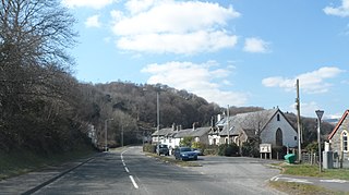
Ffridd Gate was a station on the Corris Railway in Merioneth, Wales, UK. It was built at the level crossing over the B4404 road to Llanwrin, near the hamlet of Fridd. A small hamlet also grew up around the station and a nearby (pre-existent) toll-house. The hamlet and former station are near to the confluence of the Afon Dulas and the River Dyfi, around 2+1⁄4 miles (3.6 km) west of the village of Llanwrin and 1 mile (1.6 km) north of the town of Machynlleth.
DYFI or Dyfi refers to the Democratic Youth Federation of India. It may also refer to:

Ynyslas is a small village about 1.5 miles north of Borth and 8 miles north of Aberystwyth, within the county of Ceredigion, Wales. It is sandwiched between a long sandy beach in Cardigan Bay and the beach in the Dyfi Estuary. The area between the sea and the estuary beach is made up of the Ynyslas Sand Dunes which are part of the Dyfi National Nature Reserve and home to many rare plants and animals. The sands of the estuary beach can be driven onto and parked upon. The nature reserve has a visitor centre with toilets and a small shop. At the start of some BBC 1 programmes, it shows people flying kites on the sand dunes, this was filmed at Ynyslas.
Derwenlas is a hamlet in northern Powys, Wales. It is part of the community of Cadfarch.
The Dyfi Valley Way is a long distance footpath in Mid Wales.

The Afon Dulas, or North Dulas, is a river forming the border between Merionethshire/Gwynedd and Montgomeryshire/Powys in Wales. Another river called Afon Dulas joins the Dyfi from the south, upstream of its confluence with the North Dulas: locally this is referred to as the South Dulas.

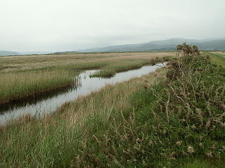
Dyfi Estuary Mudflats are mudflats on the estuary of the River Dyfi in Ceredigion, Wales, and are part of the Dyfi National Nature Reserve.

Dyfi Furnace is a restored mid 18th century charcoal fired blast furnace used for smelting iron ore. It has given its name to the adjoining hamlet of Furnace.
Afon Leri is a river in Ceredigion, Wales. It rises at Llyn Craig-y-Pistyll and is joined at Talybont by Afon Ceulan before passing behind Borth to its mouth in the Dyfi estuary at Ynyslas.

Cors Dyfi is a nature reserve located near to the village of Derwenlas, in the county of Powys, Wales. Located on land reclaimed from the Estuary on the south side of the River Dyfi, the reserve is under the management of the Montgomeryshire Wildlife Trust.

Ysgubor-y-coed is a community in the northernmost part of Ceredigion, Wales, with a population of 310 as of the 2011 UK census. It includes the villages of Eglwys Fach, Glandyfi, and Furnace, Ceredigion. It is 12 miles (19 km) from Aberystwyth.

The Dyfi Bridge, also known as the Machynlleth Bridge, Dovey Bridge, Pont Dyfi or Pont ar Dyfi, is a road bridge across the River Dyfi north of Machynlleth, Powys, Wales. It is described as "one of the finest bridges in Montgomeryshire" by the Gwynedd Archaeological Trust.

