
Uttara Kannada is a district in the Indian state of Karnataka. Uttara Kannada District is a major coastal district of Karnataka, with the largest coastal district. It is bordered by the state of Goa and Belagavi District to the north, Dharwad District and Haveri District to the east, Shivamogga District, and Udupi District to the south, and the Arabian Sea to the west.

Kumta is a town and taluk in the Uttara Kannada district of Karnataka, India. It is located 62 km (39 mi) away from Sirsi, It is one of the important stations along the Konkan Railway line running between Mumbai and Mangalore.
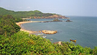
Gokarna is a small temple town located 32 km (20 mi) away from Kumta and 80 km (50 mi) from Sirsi, It has a population of around 20,000. The main temple and deity is Shiva, who is also known as Mahabaleshwara. This temple houses what is believed to be original image of Shiva's linga (Atmalinga). There are many other temples all over this small town. Ankola and Kumta on NH66 are the main towns near Gokarna where almost all trains have halts and are connected to major cities like Chennai, Bangalore, Hyderabad, Mangalore and Mumbai through bus service.

Sirsi is a city in Karnataka, Sirsi was also known as Kalyana Pattana during the Sonda Dynasty., Sirsi is a tourist destination with evergreen forest and waterfalls. It also a commercial centre in Uttara Kannada district, The main businesses around the city are mostly subsistence and agriculture-based. Adike is the primary crop grown in the nearby villages, making it one of the major trading centres for areca nut. The region is also known for spices such as cardamom, pepper, betel leaves, and vanilla. The major food crop is paddy.
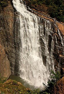
Unchalli Falls, also known as Lushington Falls, is a waterfall created by a 116-metre (381 ft) drop in the River Aghanashini. The falls are located 35 km (22 mi) from Sirsi. The falls are named for J. D. Lushington, a District Collector for the British Government, who discovered the falls in 1845.

The Indian State of Karnataka is located between 11°30' North and 18°30' North latitudes and between 74° East and 78°30' East longitude.It is situated on a tableland where the Western Ghats and Eastern Ghats converge into the complex, in the western part of the Deccan Peninsular region of India. The State is bounded by Maharashtra and Goa States in the north and northwest; by the Arabian Sea in the west; by Kerala in the south-west and Tamil Nadu in the south and south-east, Andhra Pradesh in the south-east and east and Telangana in the north-east. Karnataka extends to about 850 km (530 mi) from north to south and about 450 km (280 mi) from east to west.
Karnataka's coastline called Karavali stretches 300 km between Mangalore in Dakshina Kannada district and Karwar in Uttara Kannada district. The coastline of Karnataka has been along the eastern shore of Arabian Sea. Karnataka has one major and ten minor ports in this coastal belt. Kali, Belekeri, Gangavali, Aghanashini Sharavathi, Sharabi, Kollur, Gangolli, Sitanadi, Gurpur and Netravati are the important rivers in this belt which empty into the Arabian sea. Sea erosion, migration of river mouths, siltation of ports and harbours are some of the problems common to this belt.
Holanagadde is a village in the Uttara Kannada district of the state of Karnataka, India. It is located on the west coast beach of the Arabian sea. The main communities that live in the village are Havyakas, Namdharis, Harikanths, Patgars with a few Christian and Mukhri families. The village has a primary school which is more than 160 years old. Rice, Cashew Nuts, Beetel Nuts and Coconuts are the main crops. Carpenting and agriculture are the major occupations in the area.

Ananadasharm High School one of the oldest high schools in Uttar Kannada, was a private school located in Bankikodla-Hanehalli. Anandasharm High School is providing education from eighth standard through tenth standard. The medium of instruction is Kannada. The school was funded by Mangesh N. Kulakrni, Ananth Ramachandra Kagal family, and D. M. Nadkarni Chitrapur Saraswat Brahmins and others from Bankikodla-Hanehalli. Kulkarni was a printing press owner in Mumbai whereas Kagal was Chief Inspector of Factories, Bombay. Anandasharm is the name of ninth Guru of Chitrapur Saraswats CSBs. Ramakanth V. Pandit from Aghanashini was the first headmaster of the high school from 1941 to 1966. He was a B. A (mathematics), B.T., M.Ed. The high school is now supported by the Karnataka Secondary Education Board, Bangalore.
Dantkal is a village near Sirsi, Siddapura Taluk, North Kanara, State of Karnataka, India. All people staying there are Havyaka Brahmins, and the village is only connected with roads from Sirsi and Siddapur. This place is famous for "Kemmannu" So this place is known as Kemmannu Dantkal. The place is on the shore of river "Aghanashini". "Agha" means "sin" and "Nashini" means "remover". Dantkal is mainly famous for Ananta Bhattana Appe. This is a different type of mango. LocationsDantkal is near Balur and 1.5 km from Balur and its 9 km from Kansur. Every side full of forest. one side is in AGHANASHINI Rivar. Most of the peoples are Areconout grovers. Some of the younger generations peoples are in Bangalore, Sirsi, USA, Hyderabad etc. Dantkal from sirsi 22 km from siddapura 33 km.

Tadadi (Tadari) is one of the ports in Uttara Kannada, Karnataka, India. It is near Gokarna in Kumta taluk.

Aghanashini is a small village situated on the southern banks of River Aghanashini in the state of Karnataka, India. It is located 15 km (9.3 mi) away from Kumta and 77 km (48 mi) from Sirsi, The river Aghanashini originates at 'Shankara Honda' in the Sirsi city. It is one of the virgin rivers of the world. The water from this river flows unobstructed through the western ghats range and then joins the Arabian Sea.

Yana is a tourist destination located in forests of Malenadu, It is 55 km (34 mi) away from its nearest city Sirsi through NH 766E. Yana is one of the wettest villages in the world. It is the cleanest village in Karnataka, and the second cleanest village in India. The two unique rock outcrops near the village are a tourist attraction and easily approachable by a small trek through 0.5 kilometres (0.31 mi) of thick forests from the nearest road head.
Shri Gangadharendra Saraswati, officially Shreemajjagadguru Shankaracharya Shri Gangadharendra Saraswati Swamij, is pontiff (Guru) of Shri Sonda Swarnavalli Mutt, Sirsi, Karnataka, India. He is the 54th Guru of this mutt. He took sannyasa and ordination from Shri Jayendra Saraswathi Mahaswamiji of Kanchi Matha which is known as Kanchi kamakoti Peetham. He is a follower of Advaita Vedanta.

The following outline is provided as an overview of and topical guide to Karnataka:
The Aghanashini River is a river located in India about 18 miles south east of Anjediva Island. The village of Aghanashini is to be found at the mouth of the river. The river Aghanashini originates at 'Shankara Honda' in the Sirsi city of Uttara Karnataka. The water from this river flows unobstructed through the Western Ghats range and then joins the Arabian Sea.